Elaboração multidisciplinar e participativa de jogos de papéis: uma experiência de modelagem de acompanhamento em torno da gestão dos mananciais da Região Metropolitana de São Paulo
Raphaèle DucrotI; Pedro Roberto JacobiII; Vilma BarbanIII; Lucie ClavelIV; Maria Eugenia CarmargoV; Yara Maria Chagas de CarvalhoVI; Terezinha Joyce Fernandes FrancaVII; Suzana SendaczVIII; Wanda Maria Risso GuntherIX
IPhDoctor in Agronomics, CIRAD, Research and Management Unity of Water, Actors & Usages, France
IIFull Professor at the School of Education and Vice President of the Graduate Program of Environmental Science at the University of São Paulo - USP, Brazil
IIICoordinator of Pólis Institute Research, Formation and Consultancy in Social Policies, São Paulo
IVCurrently PhD student at the Territorial Agronomy Program, at the National Institute of Agronomics Research (INRA), France ]]>
VMaster in Environmental Science, PROCAM, São Paulo University - USP, Brazil
VIAgricultural Economy Institute - IEA, Paulista Agency of Agrobusiness Technology - APTA, São Paulo, Brazil
VIIScientific Researcher, Agricultural Economy Institute, Instituto de Economia Agrícola, Paulista Agency of Agrobusiness Technology - APTA, São Paulo, Brazil
VIIIScientific Researcher, Fishing Institute, Secretary of Agriculture and Supply of São Paulo State, Brazil
IXProfessor at the School of Public Health and at the Graduate Program of Environmental Science, at the University of São Paulo - USP, Brazil
Translated by Leonardo De Brito Jeronymo
Translation from Ambiente & sociedade, Campinas, v.11, n.2, pp. 355-372, 2008.
The development of simulation tools, such as role-playing games, presupposes the integration of the various forms of representation and knowledge, which guarantees its legitimacy and the possibility for them to be used as platforms of mediation in the discussion of socioecological conflicts. This article discusses the use of the companion modeling approach in the development of two role-playing games on the management of water and land in urban-peripheral water sources of the Metropolitan Region of São Paulo (MRSP).
Keywords: Role-playing games. Companion Modeling. Urban-peripheral water sources. Multidisciplinary integration.
RESUMO
O desenvolvimento de ferramentas de simulação, como os jogos de papéis, pressupõe a integração das várias representações e conhecimentos, o que garante a sua legitimidade e a possibilidade de os utilizar como plataforma de mediação na discussão dos conflitos socioambientais. Este artigo discute a utilização da abordagem de modelagem de acompanhamento no desenvolvimento de dois jogos de papéis sobre a gestão da água e do solo em mananciais periurbanos da Região Metropolitana de São Paulo (RMSP).
Palavras-chave: Jogo de papéis. Modelagem de acompanhamento. Manancial periurbano. Integração multidisciplinar.
1 Introduction
Environmental tensions are common in urban-peripheral areas, due to the increasing pressures on the environmental resources, as well as due to the increasing and rapid geographical, population and economical changes (ADELL, 1999). In these areas, population growth causes changes in the use of land of different nature; they are connected by land speculation processes, which induces the conversion of non-urban uses (natural vegetation or agricultural usage) to urban activities or infra-structures (such as transport routes, water reservoirs or airports). Various studies have shown that the poorest sectors of the population normally occupy areas of lower land value, and often environmentally vulnerable, thus subject to situations of environmental and sanitation risks (DOUGLAS, 1992). At the same time, the urban-peripheral interface provides conditions such as: space for water reservoir supplies, areas of absorption of pluvial waters and revitalization of underground aquifers. Therefore, the urbanization dynamics affect the hydrological processes, be it by the modification of natural hydrographical networks, be it by the increase of impervious areas, and by the pollution of waters due to the expansion of industrial activities and the inadequate sanitation management (DOUROJEANNI; JOURALEV, 1999). These processes are a fertile terrain for the development of conflicts (ABDALLA; KELSEY, 1996). Meanwhile the institutions have difficulty in dealing with the increase of tensions due to the traditional dual orientation (urban/rural) and the rapid transformations taking place (MATTINGLY, 1999), the conflicts are reinforced by the fragility of these institutions and by the confrontation of interests between powerful actors and others that are atomized and badly organized.
]]> In this direction, the tensions and difficulties faced by the water source areas of São Paulo, vastly documented and well known (BRAGA, 2000; MARCONDES, 1999), are characteristics of urban-peripheral regions of developing countries.The Negowat Project ("Negotiation Facilitation of Water Management in Urban-peripheral Area") tested the use of computerized role-playing games for the collective decisions in this area. These traditional teaching tools have received increasing attention in the last few years due to the evolution of computing, which has opened new areas of work (CECCHINI; RIZZI, 2001; DUKE, 2000). In order to use it as a platform for discussion and not only as a simple didactic tool, the game presupposes its acceptation by the different parts involved in the process of discussion, independent from the level of education or professional activity. The contents of the game and the integration of the different perspectives and knowledge are jeopardized: local, technical, or scientific; as well as the own methodology of the elaboration of the games.
The Negowat Project made use of a participatory modeling process, the companion modeling1, to develop the tested tools. This article presents the interactive and collective methodology developed for the elaboration and test of the games. The first part shows the conflicts that were studied and the two games developed as an outcome from the reflection around the situation found. The second discusses the particularities of using the games as tools within the companion modeling and its unfolding. Thereafter, the different stages of elaboration are presented and, finally, the implication of the chosen methodologies in the development of the games and in the integration of knowledge are discussed.
2 AguAloca and Ter'Águas: two tools to approach two different issues
Two environmental situations in the hydrographical basin of Alto Tietê, in the Metropolitan Region of São Paulo (MRSP) were approached: a) the relation between land market, housing situation, access to sanitation services and quality control of the overground water, associated to the issues of planning, land use and local development; b) the tensions in the common management of water quantity and quality in the planning of its use under the scope of the hydrographical basin.
The first issue was approached in the sub-basin of Guarapiranga, in the southern side of the metropolis. The sub-basin encompasses the reservoir of Guarapiranga, which supplies 25% of the urban population. With 3.8 million inhabitants, it is the most densely occupied basin in the MRSP and one of the most affected by the disordered urbanization process. The reservoir has faced high levels of organic pollution since the seventies due to the lack of sanitation services in the basin, especially, the irregular settlements being divided into plots for housing, which still takes place in the region. An important investment project during the nineties, the Guarapiranga Project did not manage to reduce the pollution in the reservoir because of the continuous high population growth within the basin. In this context, the first specific legislation of watershed management (Specific Legislation of Guarapiranga Water Basin) was established, and approved in 2006 by the State Congress after several years of debate. Apart from that, it also created the mechanisms for the development of one of the first simulation models of water quality (MQual Mwhat model) in the MRSP, which simulates the impact of changes of land use in the water quality of the reservoir.
After preliminary discussions with the Guarapiranga subcommittee, belonging to the Committee of the Hydrographical Basin of Alto Tietê2, it was decided to focus the work towards the awareness and formation of the local population to deal with the Specific Legislation, encompassing the tensions between urbanization, the supply of sanitation infrastructure and water pollution control. From this perspective, a role-playing game called Ter'Águas was developed; a computerized game developed with the multi-agent Cormas software (www.cormas.fr), programmed to simulate the negotiations about the planning of land use in urban-peripheral municipalities. It is based upon the institutional framework of the Specific Legislation of Guarapiranga hydrographical basin.
In this game, six types of actors were represented: a) the mayor, responsible for the development of services of urban infrastructure; b) the sanitation company; c) four neighborhood representatives, defending the interests of local residents; d) two small agricultural farmers from the neighborhoods surroundings; e) two big land owners with speculative and electoral interests/strategies; and f) the owner of a leisure activity that also defended the environmental preservation of the virtual basin.
The players take decision on their strategies of urban infrastructure investment, taxes and subsidies, the buying and selling of plots of land, the process of land plotting, the use of land/soil in their properties, regularization of use or license of activities and the allocation of plots of land to new residents. The computerized model allows the rapid calculation of the impact caused by the land use changes in the reservoir water quality (from an adapted version of the 'Mwhat' model), in the financial availability of the players, in the social indexes and in the unemployment index of the municipality. The model also allows the making of new plots and to allocate, in new neighborhoods, migrant families that have not found available areas in the players' neighborhoods. The first moment of the game is assigned to the individual decision making and, subsequently, the players gather together to elaborate new common strategies to be implemented in the next round. The interactions between the players focus on strategies for the control of urbanization, infrastructure investment and planning of land/soil use and land market.
]]> The second tool is geared to the Tietê-Cabeceiras sub-basin, which has 64% of its territory protected by the Water Sources Protection Legislation. The sub-basin provides 10% of the MRSP drinking water, through two interconnected systems, the Rio Claro System and the Alto Tietê-SPAT Production System. The SPAT system was initially conceived to control floods and had three reservoirs, whereas in 2005 and 2006 these numbers were increased to five in order to augment water production. This basin is the only one in MRSP that still has significant agricultural production and has agricultural farmers' representation in the subcommittee; however, due to the strong demand of water for household and industrial needs in the metropolitan region, the agricultural usage of water is increasingly being questioned. Water quality has decreased regularly, especially during the last two SPAT reservoirs. There is no consensus on the origin of this degradation, which can have different causes: the establishment of the reservoirs in agricultural areas, resulting, when filling them, in high amounts of nutrients; the increase of urbanization; agricultural contamination or transference of nutrients upstream from the reservoirs (SENDACZ et al., 2005).In order to approach the issue of water management, in other words, the articulation between water allocation among the multiple users and the evolution of its quality and its implications for agriculture, a computerized role-playing game called AguAloca (literally, it could be translated as WaterAllocation) was developed with the software multi-agent Cormas.
Based on a virtual hydrographic basin, the game simulates the negotiation of the allocation of water and its impacts to the hydro resources quality.
The virtual environmental scenario is inspired by the situation of Alto Tietê-Cabeceiras sub-basin. The basin is urban-peripheral, and includes multiple and competitive uses affected by the proximity of a big metropolitan center. Two municipalities integrate the basin (one of them typically urban-peripheral and the other rural), where agriculture and industrial activities operate under a complex hydrological system (with three reservoirs and two transferring channels). The management system aims at providing water for residential usage and to protect the metropolis, on a downstream direction, against floods. Specific legislation predicts the framing of hydro resources quality in the virtual basin.
Actors (roles) were represented in the game by the following category of players: a) the two mayors have to guarantee the access for the population to sanitation services, one of the mayors being responsible for the management of a municipal sanitation company, while the service of the other municipality is managed by an independent sanitation company, which is also responsible for supplying the metropolis found downstream; b) the framer advises the sector and defends its interests; c) the industrialist possess two factories of paper and cellulose, located in the basin; and d) the water and sewage department is responsible for the operation of the hydrological system, respecting the users' concessions.
The players have to take decisions in a period of six months (rainy or dry season). The decisions depend upon the attributions/responsibilities of the roles developed by the players and take into consideration: the goals of production, the pumping necessities and the treatment of effluents. The decisions are processed by the computerized model, in order to be translated into water demands (in terms of quantity and quality), effluents (in terms of quality and quantity) and criteria of satisfaction (in relation to quantity and quality). The players can demand concession on water sources.
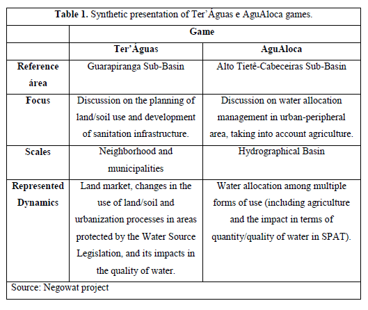
The two games have similarities (Table 1), as they consider the issue of water sources management (process of diffuse pollution, evolution in the quantity of nutrients in bodies of water and in the reservoirs), the issue of geographical dynamics (urbanization and the plotting of rural areas), the social dynamics (decision process on the use of water and interaction among the actors), and the legislation aspects (specific virtual legislation in the case of Ter'Águas; concession and framing of water quality in the case of AguAloca).
The biophysical and geographical dynamics are simulated by a computerized model using the same representational base, while the actors are physically represented by the players. A system of files allows one to gather the decisions of the players and transfer them to the computing model, so that afterwards they can be informed about the impacts of their individual and collective decisions, by using environmental indicators (such as the level of polluters) and socio-economic indicators (such as the unemployment index). The indicators serve as an interface between the virtual biophysical system and the real players. The game is based on a succession of phases (rounds of game), when individual decisions are taken or when bilateral negotiations take place, and in the group discussion, when the virtual basin situation is analyzed in search for collective solutions.
However, the focus approached in each game and the relevant scale of intervention are very different. In the first one, the level of relevant management is the local territory (various neighborhoods of the same municipality), where the change in the land occupation and use is considered. In the second, the management of the whole basin, which includes many municipalities, is considered. The represented actors are different or they have distinct roles and activities adapted to the issues and to the considered scale. In the AguAloca model, the agricultural sector is represented by an actor that has only an advisory role (orientation about the crops in two situations: organized or disorganized farmers, that generate differentiated impacts), while the farmers of Ter'Águas act on their properties and can modify the use of the land on their own account.
3 Role-playing games for the management of natural resources: different possibilities
Role-playing games are interactive games in which the players/characters discuss and decide upon a defined problem-situation, which is composed of three elements: a) a system of rules possessing an environment in which actions are developed; b) a facilitator or master of the game, responsible for the organization of the session, who knows the rules and orientates the players; c) participant players, who take on roles during the game (DARE, 2005).
In Brazil there is experience in the use of psychodrama and sociodrama games; mainly in social interaction and capacitation. Various games were developed for Environmental Education activities (CAMARGO, 2006). They are generally prescriptive and have a dramatizing/theatrical approach, with little interaction between players and virtual environment. The environmental situation is the excuse to initiate the dramatization. The governance games, however, have been developed to capacitate high level decision makers on techniques of negotiations in public policy areas, including the environmental sector (DUCROT, 2006). The games are centered in the different stages of negotiation, starting from the preparation phase, and going through the discussion table until the elaboration of an agreement. The presentation of the roles includes a thorough description of the resources (financial, administrative, political, environmental, informative, etc.) that are available for each role. The aim is to achieve the most realistic reproduction of a given social situation, in order to reproduce the complexity of the negotiation phase. These games demand from the players an important preparation for the incorporation of the roles and the awareness of the situation involved.
These two tools also allow approaching the complexity of a situation of collective decision, including the dimension of the social situation. It aims to promote a global vision of the problem-situation, the learning process, to make knowledge clear and to make possible its consequent mobilization (PAHL-WAST, 2002), making them become interesting instruments in research-action projects.
As a reality model, the role-playing games reveal themselves to be privileged tools by the group of modeling companion, which uses various sorts of models, such as platform of mediation and dialog between researchers and actors, and among the actors themselves (COLLECTIF COMMOD, 2006). This approach is based on the use of social simulation of various forms (multi-agent simulation, role-playing games) to know and strengthen the processes of collective decision of groups of interests that share common resources. The process seeks to make clear the social, institutional and biophysical components of an environmental situation, to construct a shared representation of the situation and to support processes of discussion about the solutions. In this sense, it intends to simulate the consequences of the implementation of decisions in the studied socioecological system (environmental impact, impact in the other actors, reorganization of the interactions among actors) and the interrelations, sometimes conflicting, between individual and collective decisions. The modeling companion approach also explicitly considers the development of the game as a modeling process of the studied situation. It makes explicit the interactions between actors and resources, in a simplified spatial representation of the local reality, which involves going through the choosing process of some meaningful dynamics according to the aims and the approached issue. The difficulties rest in the intrinsically multidisciplinary nature of the environmental issues and in the need to create a sufficiently simple and comprehensive representation, at the same time, capable of considering the differences of interests and interrelations of the components of the system. The multidisciplinary modeling difficulties are added to the need to integrate the different representations and perspectives of various actors with different levels of walks of life. In order to facilitate this process, the multidisciplinary group of Negowat project tested a collective modeling methodology, integrating the modeling phases and confronting it to the reality model.
]]> 4 The development games methodology
The process was developed in five stages: a) learning of the games; b) development of a common conceptual framework about the work operation of the urban-peripheral basins; c) elaboration of the subjacent models; d) development of the games materials; and e) test and validation of the tools.
4.1 Learning of the games
The bibliographical revision allowed us to highlight various aspects of the water sources management: a) degradation of the water quality in the reservoirs; b) uncontrolled urbanization, with no sanitation infrastructure; c) relation between water management
policies, the current legislation and the dynamics of urban occupation in water sources areas, linked to problems such as the devaluation of land in areas of water source preservation (APMs); d) lack of inspection; and e) lack of housing policies. Such aspects allowed the formulation of a simplified model of evolution of land use and water quality in areas of water sources, in the form of a theoretic role-playing game called JogoMan ("GameMan"). This model had the aim of capacitating the group in the role-playing games dynamics (ADAMATTI et al., 2005) associated to Cormas software3 (BOUSQUET et al., 1998), and in the implementation and monitoring of game sessions (CAMARGO, 2006).
The modeling process and the first game tests (with under-graduate and graduate students) indicated the need to better specify few processes and strategies, in particular: a) the way in which the land market works, the strategies of the actors involved and the relation to urban infrastructure management; b) the urban infrastructure implementation strategies in urban-peripheral areas; c) the determinants and modalities of land use evolution, in particular for the small owners present in the rural areas; d) the modalities of access, management and allocation of water and the main priorities between the users; and e) the local strategies (in the neighborhoods and in the small rural properties) of access to water and to the management of hydro resources of low quality.
4.2 Collective elaboration of the common conceptual framework involving the water sources urban-peripheral areas
The field work was conducted by researchers that are each specialized in their respective field of knowledge, and it did not allow an effective integration between the researchers, as each one focused in his or her specific field of work. In order to facilitate the dialogue and the multidisciplinary integration, the group elaborated a common conceptual framework, in meetings mediated by a modeling specialist. At first, the Unified Modeling Language (UML) was used to format the representation, which was later simplified in order to better identify the specificities of the interpretative framework (GRADY; JAMES, 1998).
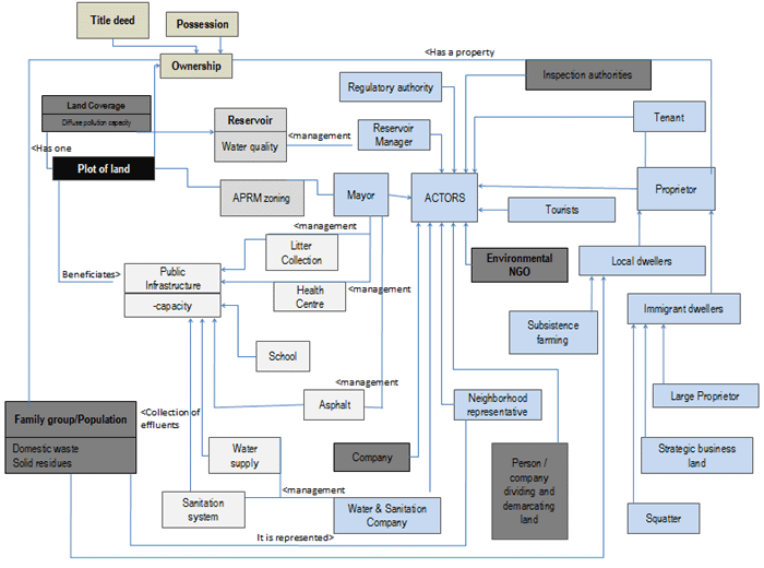
The proposed framework included: a) representation of the spatial dynamics, in particular, the use of land evolution; b) actors typology, based on the relations of property and residency, according to the direct and indirect action on the hydro resources and on the land; and c) hydrologic representation, which allowed the representation of the spatial processes, the allocation of water among uses and a simplified representation of the water quality degradation processes.
A given area, defined as a plot of land, was considered as a spatial unit of land use. The uses of land defined in each land plot generate charges of diffuse pollution (nitrogen and phosphate) in the overground waters, which can be modified by the action of the actors. The plot of land is also the support for urban infrastructure. The land occupation was represented by groups of families, in which the size defines the occupation density in the plot of land, as well as the resulting quantity of sewage. The final impact on the hydro resources depends on the proximity of the plot of land to the water courses, the use of land, the population density and the infrastructure of sanitation. New groups of families arrive at the place and search for areas to occupy. Apart from the dwellers represented by the groups of families, there are still five other types of actors being represented: a) mayors; b) sanitation company; c) working conditions manager of the hydrographic system; d) owners of non-urban plots of land who do not live in the area; and e) owners of non-urban plots of land who live in the area and who can modify its use. All actors develop activities and take daily decisions that affect directly the natural resources (such as water consumption, release of effluents or modification of the use of land). They can be organized and have representatives. Also, there are actors who only indirectly act on the resources, through legislative or monitoring actions, such as governmental bodies or inspection and control agencies. Within the category of actors producing indirect actions, there are groups of interest who have a seat on the basin committee. In the case of São Paulo water sources, in contrast to the European cities (PAHL-WOSTL, 2002), it has been defined that the actions of these groups are frequently indirect, acting as executing agents of water infrastructure development, through lobbies or consciousness promotion and capacitating of local civil society.
]]> The hydrological representation of the conceptual framework focused on the articulation between the spatial dynamics and the allocation of overground water. The underground water was not considered. The use of land generates water demands and provokes the diffuse pollution in the level of micro basin. The dwellers produce sewage that can or cannot be collected and treated through adequate sanitation infrastructure. Therefore, the changes in land use on the plot of land, translate into modification of water demands and the level of diffuse pollution at the micro basin. Only the reservoirs which export or import nutrients had its dynamics thoroughly specified. In order to simplify, it was considered that the level of the reservoirs does not vary significantly, as well as its internal heterogeneity. The reservoirs were spatially represented as a compound of plots of land, transformable and classified as being of the water type.Even though simplified, the framework showed the existence of various fundamental elements needed to understand how the peripheral urban basins generally work: a) the articulation between the dynamics of land use and land market; b) the role of urban infrastructure; c) the impact of the dynamics involved in the quality of hydro resources; and d) the difference between residential and non-residential actors in the local social interactions. It was assumed that the local permanent residents were integrated into local social networks, which reinforces the possibility of social control. The more organized the social networks are, the more residents have the chance to stay at the place. The framework limited the non-resident actors in the area into three types of users: a) owners of weekend houses; b) business men, who have interest in developing the economy of the area; c) owners of plots of land, who have less strong links to the local territory (predominantly with economic strategies) and who interact differently from the local residents to the issue of water and land.
The content of the game is presented at the beginning of the sessions, in a schematic way, and does not take into consideration the stages of evolution. This demands a stronger effort of the participants in order to define their strategies in relation to the changes of land use and water, or the implementation of infrastructure, as well as the interrelation between these factors. It is important to highlight that the elaboration of the game orients itself by issues defined in each sub region of study, in collaboration with the actors, from the results obtained in the various thematic researches and in local analysis done at the beginning of the project (Figure 1).
4.3 The use of the conceptual framework for the elaboration of the game's base
The research development dynamics demanded the formation of a working team composed of researchers belonging to all institutions involved, so being responsible for developing the subjacent model to the game, including the strategies to bring awareness to the actors involved. The subjacent model (Figure 2) specified: a) the tasks, the indicators and the necessary information for decision making; b) the main relations between each type of social actors involved; and c) the reference framework that influences the decision of each actor.
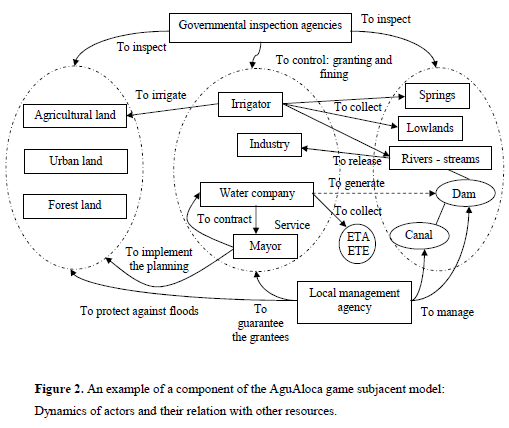
In the two games, the model was based on the conceptual framework defined above and was detailed, for each studied situation, from the methodology proposed by the accompanying modeling group. For instance, the AguAloca group detailed the relations between land and water that affect the water quality, meanwhile the Ter'Águas group explicated the mechanisms of land use evolution.
]]> The key-actors of the process and the impact of their actions on the physical resources were detailed through a rapid specification of the modalities of interaction between actors, which can be of contractual order, market, service, etc. Finally, for each actor the spatial and temporal scale of reference related to the decision making process in the game was identified.Various meetings of the two groups of work were held in order to finish the model, including specific moments of interaction with key-actors, aiming at integrating their representations and knowledge. For the Ter'Águas game, workshops with local residents representatives of the working class neighborhoods were developed. This allowed collecting the local actors' representations on the various issues and identifying the negotiations strategies in relation to the sanitation company and to the municipal government. It was observed that residents had the tendency to mainly focus on the more visible aspects of the problem (such as solid residues in the rivers or invasion of rats), rather than the pollution by sewage, the main problem of the basin. Apart from that, it was verified that they do not trust their public representatives, that they desire an increase in their quality of life and, in particular, that they want more information on how to adequate their situation to the current legal norms (BARBAN, 2005). In order to specify the management strategies and indexes for the AguAloca game, the game itself and the subjacent model hypotheses were presented and discussed in meetings held with researchers and representatives of the basin subcommittee.
4.4 The elaboration of the support materials for the game
The following phase consisted of developing the support materials for the game (game board, computerized model, rules and cards). For that to happen, first of all it was necessary to choose a common spatial and temporal unit. In the case of the AguAloca game, which represents a big area, its spatial base unit is five square kilometers, whereas its temporal base unit is six months. In the Ter'águas game, the spatial base unit is one hectare and its temporal base is one year. The framework for the game, in which the actions of the players take place, was drawn up using the spatial base unit. In the games of the ComMod type, the spatial representation (maps) does not only have the aim of facilitating the incorporation of the roles, but it is also the bearer of the environmental dynamics and/or of the actions of the players.
It was decided to format the population and natural dynamics by using the multiagent Cormas software, which resulted in the elaboration of the computerized game. These games facilitate the fulfillment of tasks and calculations that represent the complexity of environmental dynamics, such as water flows or the process of environmental pollution diffusion, which, done in a different way, would be difficult to represent. It is important to highlight, therefore, that a full manual version of the Ter'Águas game was evaluated as being too formal, or not playful enough, and only adequate for the didactic use. The use of a computer game also facilitates the monitoring and evaluation of a game session, by providing the possibility of registering all stages and the decision making, which can help in the collective analysis of the game and to discern, understand and better analyze the impact of different chosen options and strategies. However, the computerized games also have important disadvantages, in a way that it can become a "black box" for some users, capable of giving magic answers, as well as not being flexible enough, in other words, the solutions' options and alternatives become limited to the alternatives incorporated into the model. The interface between the players and the computer can also be difficult to manage or to comprehend.
4.5 Test and validation
The last stage consisted of the testing of the games, the evaluation of their viability, and the validations of the subjacent model and the proximity to the representations of the main actors. The first tests, held with members of the project and students, allowed the verification and improvement of the playability and ergonomic aspects of the framework, however, without validating the content of the game and the base models, as the students, even those coursing the graduate degree, rarely demonstrate knowledge and experience of the represented situation in order to allow this validation. The more one does not know about the problems, the more there is the tendency to play the game and to seek for the individual performance measured by the points allowed by the rules, independently of the experienced situation, and moving away from situations of conflict. Thus, the validation of the global representation is done by actors involved in the decision making process. The considered elements for the validation of the representation were: a) the choices and simplifications made; b) the used indicators and information; c) the providences and the selected interaction rules. The validation tests produced the incorporation of some functions not previously considered, as well as the spatial simplification of the game, which resulted in a better framework and put away the spatial base of real maps.
5 Discussion
5.1 The games as a reality model
]]> The elaboration of the games always results from a process that combines, through stages, the formal modeling, field research and validation tests. The researchers' work of modeling hypothesis confrontation, together with the reality and the local actors' representations, was followed by a substantial modification of the subjacent models of the games. A model elaborated from the literature and the representations of some institutional actors, the first game (JogoMan [ManGame]) was evaluated as inadequate, even though it was playable, and didactically interesting to discuss the role of the basin committee. It did not adequately present some essential functions and tended to make the migrants responsible for the process of population growth, while the reality is much more complex. It is worth to remember that role-playing games can be tools that potentiate an ethically inadequate utilization, due to the possibility of orienting the representations about the functioning of a real situation according to its content. It is exactly for this reason that the methodology of the subjacent modeling specification is so important.The games were inspired by real situations, purposely simplified to become a virtual situation. In the Ter'Águas game, the urbanizing process was limited to a process of plotting of land by the owner (simultaneous sharing and selling of the land to several families). In reality, other modalities can be found, such as the progressive division of the plots of land, which tend to generate more populated areas (BUENO, 2004). It is still important to highlight that the validation tests with actors meant to framework even further the geographical representation, in detriment to the true geographic base.
One of the aims of the game is to stimulate the players to a virtual scenario very close to that of reality itself to trace a parallel with their experiences and knowledge, at the same time it is sufficiently thought through and organized to analyze the real system. It is not the case, for instance, of reproducing the negotiations exactly as they happen. This objective would be valid if the results of the simulation were to be used in reality. In this case, however, it can be questioned why there is the need to reconstruct a complex virtual situation such as reality, instead of using the real scenario directly. The fundamental orienting question to define the representation of reality then is how to do it in a way that the subjacent process of negotiations is made comprehensible to the participants.
Therefore, the distancing of reality, provided by the virtual scenario, allows the distancing of the personal links with the environment. It opens space for the redefinition of other levels of discussion, while their own participation obliges the players to formalize explicitly their relations, allowing them to be analyzed. Therefore, the modeling process extends itself to the definition of roles. In games such as ComMod, the roles are only defined by actions and decisions susceptible to affect the natural resources, corresponding to an action based upon strategies/interests. Other types of games can specify the personal relations with the environment or the power relations among actors, an essential component of the definition of the role-playing games of governance.
The definition of role content is important and its impact depends on the type of public being considered. For a poorly informed public, roles feebly defined are difficult to incorporate and make complicated the participation in the game, restricting the action on the virtual level. However, when people are well informed (an actor that plays his/her own role, independently of his/her level of education), a higher specification of the role can be perceived as restrictive of his/her playing role, forcing him/her to act towards a determined direction. As it is expected that the players project in the game, at least partially, their proceedings and modalities of interaction found in real life, the challenge consists of providing the minimum necessary information so that the player acts, even if he/she is not representing the role in which he/she has affinity in real life.
It was purposely chosen to develop two different games, on different scales, detailing the hydrological dynamics (AguAloca) and the real state dynamics (Ter'Águas). It would have been possible to develop only one game, but this integration would necessarily mean more complexity: an increase in the number of roles, actors, decisions and indicators to be considered. A complex game necessarily demands a preparing phase for the learning of the virtual scenario, which can be more important than the game itself. There is also the tendency for the game to loose its playable characteristic, a fundamental element to facilitate the mobilization of actors and a discussion in a non-conflictive locus. Moreover, complex models end up loosing their explanatory and analytical capacities. Consequently, when the aim of the game is to use it in the process of modeling companion, the challenge in its elaboration rests in the equilibrium between the reproduction of elements of reality and its simplification, so that they become comprehensible.
5.2 Integration of local actors and managers' knowledge
The local actors' knowledge was integrated to the model in two ways: a) indirectly, formatted as soon as they had been perceived by the researchers that participated in the workshops with the local communities; and b) directly, through the incorporation of criticisms made against the base model, during the validation sessions. The Ter'Águas workshops particularly pointed to: a) the variability of the supply of water sources among neighborhoods and households; b) the preoccupation of local residents in relation to the urban infrastructure, not only linked to the water issue (i.e. school, transport, health); and c) the diversity of neighborhoods and the related environmental preoccupations.
It is worth remembering that companion modeling games present difficulties to integrate actors who do not have direct action on the natural resources.
In the Ter'Águas' workshops held with the local actors, the preoccupation in relation to the neighborhood and the plots of land of each actor became manifest. Even when well informed, the more active representatives limited their actions to their neighborhood realm, having difficulties in thinking about the common problems they have with the other neighborhoods and in projecting the discussions outside the specific situation. This stimulated an individual action by the neighborhood representatives, and made difficult the collective articulation and organization in the context of the municipality. In reality, some experiences had already shown that whenever the differences in walks of life are not too significant it is possible to integrate residents and other local actors in collective processes of modeling and construction of models. In Senegal, a three day workshop allowed the rules of land use and access to water to be made explicit among the farmers and nomadic shepherds during the elaboration of a multi-agent model that served as a framework to discuss the development of certain areas (D'AQUINO et al., 2003). In the Pacific region, the actors' representations were rescued through interviews based on photographs, followed by a discourse analysis and then the transformation into a model by specialists. The model was validated by the role-playing game that was developed (DRAY et al., 2006). In the Negowat-Ter'Águas project, one of the workshops held with a group of health workers showed that it is possible to use this methodology to represent the mechanisms promoting urbanization. However, it was not possible to confront, in the same workshop, the representations of actors of different backgrounds and walks of life (such as institutional actors, local actors and researchers), which would have shown the reach of the modeling companion method. The time to elaborate and the availability of the different groups were factors that made the interaction between these diverse set of groups difficult. Therefore, the different walks of life and asymmetries in the relations between actors put into question the possibility of having a true dialog without a previous preparation of the local actors.
]]> 5.3 Collective learningApart from (re)discovering the potentiality of the role-playing games and that of possible paths of social and spatial computerized representation, which makes explicit the environmental processes through the multi-agent modeling, the collaborative model, based on a participative modeling attitude, was perceived as being a particularly important instrument to promote collective learning in the group. The integration of individual knowledge, through the visual simulation of its consequences that considered its specificities in a language accessible to all participants, the collective selection of the model structuring elements and the effort of minimum quantification of processes allowed for the interchanging of information among the researchers, but also to point out weaknesses and critical elements of the generated knowledge. In this moment of collective meeting, where each one of the participants exposes, structures and synthesizes its own knowledge, it becomes possible to understand and to acquire information from other areas. At the same time, the meeting enables the verification of the relevance of the interpretations and representations started to be elaborated in the fieldwork, therefore, allowing the refinement process of the modeling standard. As outcomes of these interactions, the games are thus visible and collective.
The work of collective integration, however, had questions associated with the time of execution, which brought important questions to be reflected upon. Difficulties in the mobilization of the teams limited the collective elaboration work of the conceptual base
of the games, at the same time the detailed specifications of the content and the computerized work were implemented by a small team of modeling specialists. The consequence is that the access to the computerized part of the games became restricted to some researchers, becoming a "black box" for the rest of the team. The collective and detailed development of the game is possible. It consists of writing each action or task developed by the actors in a grammatically simplified language, with simple phrases (subject verb complement), however, completely comprehensible.
These phrases are later transformed into adequate computerized codes. The collective formulation work, however, demands a time and it was not tested by the project, due to difficulties of mobilization.
Another important difficulty is that the collective construction consolidates itself if the participants have a thorough practical knowledge about reality. The initial attempts to interact with researchers that only had theoretical representations of the dynamics led to general discussions that were not as meaningful in terms of intervention and collective learning. As a consequence, the potentiality of interaction only began to become apparent after few months of thematic fieldwork. However, the implementation of parallel activities to the thematic research, such as interactive workshops with actors involved and the collective workshops among researchers, made difficult the understanding of the collective modeling sequence of activities, the individual logic of each researcher and the articulation between these different activities.
6. Conclusion
In the last forty years many experiences were developed in the use of role-playing games to help the management of environmental processes. The advances in the field of computer science allowed the development of tools with which it is possible to implement the decisions taken by the players and to discuss the consequences in the hydro-social system. More than the incorporation of a computerized base, role-playing games based on the companion modeling approach are innovative because of the aggregation of the following aspects: a) as mediation tools among actors that participate in the environmental management, including technicians and researchers; b) as models that combine the representation of natural and social dynamics; and c) as tools that envisage the approximation of the questions elaborated by the scientific researchers to those raised among the social actors involved in the system. It constitutes a platform of collective learning, aiming at constructing an integrated and multidisciplinary vision about the reality among researchers, decision makers and local actors, as well as facilitating the dialogue, sharing of knowledge and taking of decisions facing the lived reality, promoting the reflection about the processes involved and the comprehension/visualization of future sceneries.
In this direction, the process of game elaboration is fundamental in relation to the session of the game itself. It is an important opportunity to integrate different levels of knowledge, scientific, technical and local. Therefore, more than an exercise of development of a pedagogical tool, the elaboration of games was explicitly treated as a modeling process. This collective and participatory work enabled the collective learning of the participants, and integrated researchers and actors. For many researchers involved in the project, the work allowed them to (re)discover the interest for the tool the role-playing game as an instrument of training, capacitating and, finally, intervention. The two games developed were used in a pilot experience of support to a shared management practice with social actors, allowing the strengthening of the collective decision processes of groups.
]]>Acknowledgements
To the European Community, FAPESP and DFID for their financial support. This work would not have been accomplished without the participation of the various people from DAEE, SABESP, the Parelheiros, Mogi das Cruzes, Suzano, Poá, Salesópolis and Biritiba Mirim municipal and sub-municipal governments, and the communities of these municipalities, as well as the different research and student groups from USP, UMC, UNICAMP, UNISA and APTA.
Bibliography
ABDALLA, C.; KELSEY, T. W. Breaking the impasse: Helping communities cope with change at the rural-urban interface. Journal of soil and water conservation, Ankeny, v. 51, n. 6, p. 462-466, Nov-Dec, 1996.
ADAMATTI, D. F. et al. JogoMan: A Prototype Using Multi-Agent-Based Simulation and Role-Playing Games in Water Management. In: JOINT CONFERENCE ON MULTI-AGENT MODELLING FOR ENVIRONMENTAL MANAGEMENT (CABM-HEMA-SMAGET), Bourg-Saint-Maurice, Les Arcs, France, 2005. Proceedings.
ADELL, G. Theories and models of the periurban interface: a changing conceptual landscape. Literature review. London: The Development Planning Unit, 1999.
BARBAN, V. Entre o legal e o real - a necessidade de informação para a participação cidadã. In: DOWBOR, L.; TAGNIN, R. A. (Orgs). Administrando a água como se fosse importante: gestão ambiental e sustentabilidade. São Paulo: Ed. Senac, São Paulo, 2005.
BOUSQUET, F. et al. Cormas: common-pool resources and multi-agent Systems. Lecture Notes in Artificial Intelligence 1416. [S.I.]: Springer, 1998. p. 826-838.
BRAGA Jr, B. P. F. The management of urban water conflicts in the Metropolitan Region of São Paulo. Water International, Johannesburg, v. 25, n. 2, p. 208-213, 2000.
BUENO, A. K. D. S. A lei de proteção aos mananciais e mercado de terras: um estudo sobre loteamentos clandestinos. Campinas, 2004. 151 p. + Anexos f. Dissertação - Instituto de Economia, Universidade de Campinas - UNICAMP.
CAMARGO, M. E. Jogo de papéis em diálogo com a educação ambiental: aprendendo a participar da gestão dos recursos hídricos na região metropolitana de São Paulo. São Paulo, 2006. f. Dissertação - (Programa de Pós-Graduação em Ciências Ambientais), Universidade de São Paulo.
CECCHINI, A.; RIZZI P. Is urban gaming useful? Simulation and Gaming, USA, v. 32, n. 4, p. 507-521, 2001.
COLLECTIF COMMOD. La modélisation d'accompagnement. In: Phan D. Amblard F.(Ed.). Modélisation et simulation multi-agents pour les Sciences de l'Homme et de la Société : une introduction. Paris: Lavoisier, 2006. p. 217-228.
D'AQUINO, P. et al. Self-designed role-playing game and multi-agent system to empower a local decision-making process on land use management: the SelfCormas experiment in Senegal. In: BIENNIAL CONFERENCE OF THE INTERNATIONAL SOCIETY FOR ECOLOGICAL ECONOMICS, 7, 2002, 8-10 mars 2002, Sousse, Tunisie, 2003.
DARE, W. S. Comportements des acteurs dans le jeu et dans la réalité: indépendance ou correspondance ? Analyse sociologique de l'utilisation de jeux de rôles en aide à la concertation. Paris, 2005. 401 f. Dissertation - (Sciences de l'environnement), ENGREF.
DOUROJEANNI, A.; JOURALEV, A. Gestión de cuencas y rios vinculados con centros urbanos. Santiago: CEPAL, 1999. 176 p.
DRAY, A. et al. The AtollGame Experience: from Knowledge Engineering to a Computer-Assisted Role Playing Game. Journal of Artificial Societies and Social Simulation, Surrey, v. 9, n. 1, 2006. Disponível em: <http://jasss.soc.surrey.ac.uk/9/1/6.html> .
DUCROT, R.; GRANJA, S. I. B.; CAMARGO, M. E. Role Playing Games: Ferramenta para Construção de Consensos Gradativos. In: ENCONTRO DA ANPPAS, 3, 2006, 23 a 26 de maio, Brasília-DF, Brasil. Disponível em: <http://143.106.158.6/anppas/SISGEENCO/arquivos/TA548-10032006-095340.DOC> .
DUKE, R. D. A personal perspective on the evolution of gaming. Simulation and Gaming, USA, v. 31, n. 1, p. 79-85, 2000.
GRADY, B.; JAMES, R.; IVAR, J. The Unified Modeling Language User Guide. [S.I]: [s.n.], 1998.
MARCONDES, M. J. A. Cidade e natureza: proteção dos mananciais e exclusão social. São Paulo: Studio Nobel, Editora da USP, FAPESP, 1999.
MATTINGLY, M. Institutional structures and progresses for environmental planning and management of the periurban interface. London: University College London, 1999. 9 p.
PAHL-WOSTL, C. Toward sustainability in the water sector - the importance of human actors and processes of social learning. Aquatic sciences, Birkhäuser, v. 64, n. 4, p. 394-411, 2002.
Notes
1 Modeling companion is a methodology developed by COLLETIF COMMOD (www.comod.org). It intends to approximate the questions and issues elaborated by the scientific researchers to the ones raised among the social actors involved in the system. It is constituted of a platform of collective learning, aiming at constructing an integrated vision of reality among researchers, decision makers and local actors, as well as facilitating the dialog, the sharing of knowledge and the taking of collective decisions in an intervention.
2 The Alto Tietê Committee expanded its decentralization in1997, organizing itself into five regional Sub-Committes.
3 Common-Pool Resources and Multi-Agent Systems (http://cormas.cirad.fr/).
 Corresponding author:
Raphaele Ducrot
FUNCEME
Av. Rui Barbosa, 146
Post code 60115-221, Fortaleza - CE, Brazil
E-mail: raphaele.ducrot@cirad.fr
Pedro Roberto Jacobi
São Paulo University - PROCAM/USP ]]>
Rua do Anfiteatro, 181, Colmeias, Favo 14
Post code 05508-900 São Paulo, Brazil
E-mail: prjacobi@usp.br