


Mi SciELO
 Servicios personalizados
 Inglés (pdf)
 Articulo en XML
 Referencias del artículo
 Enviar articulo por email
 Citado por SciELO

 Permalink
Estudos Sociedade e Agricultura
versión impresa ISSN 1413-0580
Estud.soc.agric. v.1 n.se Rio de Janeiro 2005
The rural dimension of Brasil
A dimensão rural do Brasil
José Eli da Veiga
Professor in the Economics Faculty of the University of São Paulo (FEA/USP)
Translated by Enrique J. Romera
Translation from Estudos Sociedade e Agricultura, Rio de Janeiro, v.12, n.1, p.71-94, Apr. 2004.
ABSTRACT
Brazil is less urbanized than the official data shows, if its present situation is analyzed with: a) methodologies recently adopted in developed nations, b) indicators of rural development trends in the most structured human societies. By adopting procedures based on the work of OECD's Territorial Development Service, and incorporating additional factors that go beyond the urban-rural dichotomy, it is possible to realize that, in Brazil, 80% of the municipalities and 30% of the population make up the rural regions of the country. Contrary to what is commonly believed, there is nothing wrong with this panorama, since some of the main competitive advantages of the 21st Century will depend upon the strength of rural economies.
Key words: rurality, Brazil, urban hierarchy, territory, development, dichotomy, contradiction.
RESUMO
O Brasil surge menos urbano do que oficialmente se calcula quando se analisa a atual configuração territorial do país tendoem corte: a) metodologias recentemente adotadas no primeiro mundo e b) indicadores disponíveis sobre o destino da ruralidade nas sociedades humanas mais avançadas. Adotando-se procedimentos inspirados na contribuição do Serviço de Desenvolvimento Territorial da OCDE - mas que realmente superem a visão dicotômica - nota-se que 80% dos municípios e 30% da população pertencem ao lado essencialmente rural do país. E, ao contrário do que se pensa, isso nada tem de negativo, já que algumas das principais vantagens competitivas do século XXI dependerão da força das economias rurais.
Palavras-chave: ruralidade, Brasil, hierarquia urbana, território, desenvolvimento, dicotomia, contradição.
Introduction
For some considerable time, the international scientific debate on the possible future of rurality in the contemporary world has ceased erroneously equating the latter with agriculture, as if there were some kind of equivalence between the economic activities of this sector and the (physical and social) space where they occur. In addition, the emergence in many rural areas of activities that have little or nothing to do with agriculture has triggered intense debate on the characteristics and trends of what has been called the "new rural economy". In the developed nations such rurality is normally classified as "post-industrial", "post-modern" or "post-Fordist".
Brazil's immense size and hugely uneven development have given rise to extreme rural situations. On the one hand, there are still forms of anthropic pressure in the vast Amazon forests that maintain a pre-Neolithic relationship with nature; on the other, there are several examples of a highly advanced rural economies in temperate areas of the Atlantic rain forest, and above all, in the southern plains and forests. There is no reason, therefore, for Brazil to be excluded from the crucial debate on the possible future of rurality. However, there are at least two fundamental preceding questions to be asked: what exactly is rurality and how can we measure it? In fact, these two questions are themselves of such complexity that this paper will be devoted to them. Thus, before proposing a means of evaluating the relative importance of rural Brazil (section 3) and drawing attention to certain theoretical-historical implications of the problem (section 4), this paper deals with the urban-rural divide, seeking explanations for the surprising inertia in the way in which the space is understood, and presents the main alternatives being adopted in other countries (section 2).
Attempts to overcome the inertia of the urban-rural divide
The rise of the cities in Europe, between the 10th and 12th centuries, was a watershed in the history of the west and, therefore, the world. However, in the 13th and 14th centuries their relationship with the surrounding areas became radically modified, breaching the framework of what the historian Carlo M. Cipolla (1976) has termed the "urban versus rural cultural dichotomy". His colleague Georges Duby (1973), with even more precision, puts the beginnings of the urban economy's domination in Europe in the last two decades of the 12th century. One question seems inevitable, therefore: why has such a dichotomy survived in the demographic statistics up to the beginning of the 21st century?
Even though the urban-rural conflict has gone on for six or seven centuries, the divide remains in the statistics because some of its aspects were still valid until the middle of the 20th century, health being one example. When the UN published its first analysis of urbanization trends and characteristics – in the Demographic Yearbook for 1952 – two notable facts appeared to confirm that the dichotomy maintained its full significance: both fertility and infant mortality were highly distinct in the urban and rural populations. In 1940, the rural fertility rate was still double the urban rate in countries as different as Finland and Panama. In addition, rural infant mortality was superior in more than 80% of the countries with reasonable statistics. Fifty years later, the Demographic Yearbook shows that fertility rates are still systematically lower among urban populations, although the same cannot be said for infant mortality. (Champion and Hugo, 2003).
In Brazil, one of the main indicators that seems to confirm the divide's continuing statistical presence is the gender ratio. In the northeast, southeast and southern regions, there are few cases of male predominance among urban populations, while in all regions the number of men is systematically higher than the number of women in rural populations. On page 42 of the 2000 Demographic Census Atlas, published by the IBGE (Brazilian Institute of Geography and Statistics), there is a graph that strongly exemplifies the reasons behind the statistical inertia of the urban-rural divide.
However, the fact that fertility and male predominance remain systematically higher in rural areas is not enough in itself to justify the belief that this is the main spatial frontier between population categories. Internal differences among urban (or rural) populations may be even more significant. For example, recent studies indicate that fertility also varies in inverse ratio to the size of the urban population. For this and other reasons, dissatisfaction with the simple urban-rural divide has been growing in the last few decades. This does not mean however, that such spatial (or territorial) differences are irrelevant. It is therefore crucial to examine other options of territorial demographic approach which arose at the end of the 20th century.
During the 1970s there were persistent international recommendations to classify the population into four categories: "urban metropolitan", "rural metropolitan ", "urban non-metropolitan" and "rural non-metropolitan" (Champion and Hugo, 2003). However, this inclination to deepen the divide ended up producing heterogeneous results, which were also very different from those originally intended.
In the United States two official classifications coexist: those of the U. S. Census Bureau and those of the Office of Management and Budget (OMB). For the former, urban areas are more densely populated, but do not correspond to politico-administrative divisions. They can also be divided into two types: urbanized areas or urban clusters. An urbanized area has a population of more than 50,000 people (even if there is no specific city or town with this number of inhabitants), a core with a density of over 386 inhabitants per square kilometer (inhab/km2), and may have an adjacent zone with a minimum of half this density (193 inhab/km2). Urban clusters – a notion only adopted after the 2000 census – are locations with lower populations (between 50,000 and 2,500), but with the same demographic density levels. Thus, for the Census Bureau, the rural population is defined as that which is found outside both urbanized areas and urban clusters. In 2000, 68% of the American population lived in 452 urbanized areas, 11% in 3,158 urban clusters and the remaining 21% (59 million people) in the immense rural areas.
Unlike the Bureau, whose data are provided every ten years, the OMB issues annual population, employment and income estimates. In addition, its classification is politico-administrative in nature and essentially separates metropolitan ("metro") and non-metropolitan ("non-metro") counties. A county is considered economically tied to a metropolitan agglomeration if 25% of the resident workers commute to the central counties, or if 25% of its employment consists of workers originating in the central counties (the so-called reverse commuting pattern). Moreover, the "non-metro" counties are further subdivided into two categories: "micropolitan areas", centered on urban clusters of more than 10,000 inhabitants, and all remaining "noncore" counties.
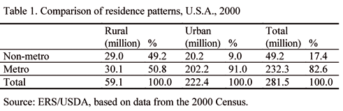
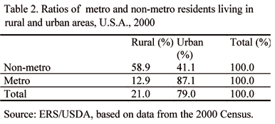
For analytical purposes, the Economic Rural Service (ERS), linked to the United States Department of Agriculture (USDA) adopts a hybrid system that results in a mixture of the two official normative classifications. Its latest statistical figures are shown in Tables 1 and 2.
To sum up, we can say that the case of the United States is rather an ambiguous one. On the one hand, the Census Bureau replaced the urban-rural dichotomy with an interesting trichotomy comprising urbanized areas, urban clusters and rural areas. On the other, the OMB preferred a new dichotomy – metro versus non-metro. And, for analytical reasons, the ERS/USDA intensified the idea of the divide by proposing a mixture which does away with the Bureau's recently introduced trichotomy.
The OECD encountered a very different solution. After a thorough analysis of the statistics from 50,000 communities in the 2,000 micro-regions in its 26 member nations, its Territorial Development Service distinguished two analytical levels. Firstly, at the local level, only the smaller administrative units or smaller statistical units were classified as urban or rural. For example: kreise in Germany, municípios in Spain, counties in the U.S.A., cantons in France, comuni in Italy, concelhos in Portugal and districts in the United Kingdom. Secondly, at the micro-regional level, functional units – such as provinces, commuting zones or Local Authority Regions – were classified as "predominately urban", "predominantly rural" or "intermediate".
The OECD classifies any locations with a population density lower than 150 inhab/km2 (or in the specific case of Japan, 500 inhab/km2) as rural. According to this definition, around one-third (35%) of the OECD population lives in rural areas which cover more than 90% of its territory, although these ratios vary considerably from nation to nation. Rural communities make up less than 10% of the total population in countries such as Holland and Belgium and more than 50% in the Scandinavian nations.
However, as the options and opportunities open to these rural areas depend essentially on their relationship with the urban centers, the micro-regional approach is of real importance. For analytical purposes, the OECD classified its 2,000 micro-regions into three categories, according to the ratio of the population living in rural communities. In regions considered predominantly rural, this ratio is over 50%; in areas considered substantially rural, it is between 15% and 50%, while in the predominantly urban regions, it is below 15%.
About a quarter (28%) of the OECD's population reside in predominantly rural regions, which are generally extremely remote and where most people live in small settlements spread throughout the territory. At the other end of the scale, around 40% are concentrated in less than 3% of the territory – the predominantly urban regions. The remaining third (32%) reside in the intermediate regions, termed significantly or relatively rural. Finally, each of the three types of region contains rural and urban communities, but to differing degrees. Whilst in some Scandinavian countries the relative shares of predominantly or significantly rural regions is higher, the exact opposite is true in countries such as Belgium, the United Kingdom and Germany. In 1996, only 30% of the American population lived in predominantly urban commuting zones. The predominantly rural areas housed 36% and 34% resided in the intermediate areas. Moreover, 44% of the American population lived in rural counties, with less than 150 inhab/km2 (OECD, 1996).
In short, the urban-rural dichotomy has been maintained at the local level by the OECD as a stage to be surpassed at the micro-regional level by a trichotomy comprising essentially urban, intermediate and essentially rural areas.
The peculiar case of Brazil
An understanding of Brazil's urbanization process is seriously jeopardized by the application of a rule that is found nowhere else in the world. Here, all the municipal and district administrative centers are considered urban regardless of their structural or functional characteristics. An extreme example can be seen in Rio Grande do Sul, where the administrative center of the municipality of Union da Serra is a "city" where the 2000 Demographic Census recorded a mere 18 inhabitants.
This would not be too alarming if it were a glaring exception. However, it would be utterly wrong to assume that we are dealing with a few aberrations that do not jeopardize the overall analysis of Brazil's territorial configuration. Of the 5,507 municipal centers in 2000, 1,176 had less than 2,000 inhabitants, 3,887 had less than 10,000 and 4,642 had less than 20,000. However, all of these possessed the legal statutes of a city identical to those of the unmistakable cores forming metropolitan regions or of "true" urban centers. And all the residents of even the smallest of the district centers are officially computed as urban. Such madness helps explain why Brazils official urbanization ratio totaled a massive 81.2% in the same year.
Many academics have tried to avoid this obstacle by adopting another rule – for analytical purposes, the populations of extremely small municipalities with less than 20,000 inhabitants should not be considered urban. According to this convention, which has been applied since 1950, all 4,024 municipalities with a population of less than 20,000 inhabitants in 2000 should be classified as rural, thus reducing the countrys total urbanization ratio to 70%.
The great advantage of this criterion lies in its simplicity. However, there are municipalities with less than 20,000 inhabitants that have high population densities, some of which are part of metropolitan regions and other urban agglomerations, two indicators which better characterize the urban phenomenon. Or rather, in order for the analysis of the territorial configuration to avoid the illusion imposed by the legal norm, we must combine the size of the municipal population with at least two other criteria: demographic density and location. The most urban of inhabitants are those found in the 12 metropolitan agglomerations, the 37 other agglomerations and the remaining 77 urban centers identified by the highly competent joint survey undertaken by the Ipea (Institute for Applied Economic Research), the IBGE and the University of Campinas, resulting in the Série Caracterização e Tendências da Rede Urbana do Brasil (1999 e 2002) Characterization and Trends of the Brazilian Urban Network (1999 and 2002). This urban web, comprising 455 municipalities from the three types of concentration, contained 57% of the total population in 2000. This is the side of Brazil, which is indisputably urban.
The problem, therefore, is to take the remaining 5,052 municipalities and separate those that cannot be considered urban from those considered to be "in-between", in an ambiguous situation. To make this type of distinction, the decisive criterion is demographic density. This will be the kernel of the so-called "anthropic pressure index", when it eventually materializes. This is the indicator that most accurately reflects the changes in the natural environment resulting from human activity. Nothing can be more rural than areas of virtually unspoiled nature and there are no ecosystems that have been more altered by human activity than the megalopolis. This is why we consider anthropic pressure to be the best indicator of the degree of ecosystem artificialization and, therefore, the degree of territorial urbanization.
The biggest difficulty, however, does not lie in the selection of the criterion per se. The main problem is how to arrive at the cut-off point, i.e. what is the limit of demographic density beyond which a given territory ceases to belong to the most rural classification and falls into another category? For some considerable time, 60 inhab/km2 was considered a reasonable cut-off. This was the figure adopted by Davidovich and Lima (1975) when dealing with data from the 1970 Census. However, an examination of the data from the 2000 Census data appears to justify increasing the ratio to 80 inhab/km2.
If we examine demographic density trends as municipal populations diminish, we can clearly identify two sharp falls. While in municipalities with more than 100,000 inhabitants, considered as urban centers by the above-mentioned Ipea/IBGE//Unicamp survey, the average density is greater than 80 inhab/km2, in the category immediately below (between 75,000 and 100,000 inhabitants) it drops abruptly to less than 20 inhab/km2. A similar phenomenon occurs between the categories above and below 50,000 inhabitants (50,000-75,000 and 20,000-50,000). In this case, the average density plunges to 10 inhab/km2. It is these two reductions that allow us to classify municipalities with less than 50,000 inhabitants or with less than 80 inhab/km2 as small, and ones with between 50,000 and 100,000 inhabitants or with a density of 80 inhab/km2 or more as medium-sized, even (in the latter case) if they have a population of less than 50,000.
With the aid of these two cut-offs, we can estimate that 13% of people living in 10% of the municipalities neither belong to the indisputably urban Brazil, nor to its definitively rural counterpart. We can also see that essentially rural Brazil comprises 80% of the municipalities, containing 30% of the total population. In contrast to the absurd prevailing rule created during the most totalitarian period of the "New State" by Decree-Law 311/38 – this typology allows us to understand that true cities only exist in the 455 municipalities constituting urban Brazil. The administrative centers of the 4,485 rural municipalities are villages and the centers of the 567 intermediate municipalities are towns, of which only some will become new cities.
The most important thing, however, is a trend that should not be overlooked. Even if we add all the medium-sized municipalities to the urban category, treating them as towns, which may eventually grow into urban centers or cities, we arrive at a total of 1,022 municipalities, containing almost 118 million people in 2000. In this extended subgroup, population growth between 1991 and the latter year was nearly 20%, led by the non-metropolitan agglomerations and urban centers. But we should not deduce from this (as is all too frequently done) that all the other municipalities – the small, rural ones – have suffered a decline in population. This did, in fact, occur in half of these municipalities, but a quarter actually recorded a population increase of 31.3%, well above the urban figure and more than double that of the countrys total population growth (15.5% between the 1991 and 2000 Census).
Very little is known of the factors that caused these 1,109 rural municipalities to experience such significant demographic growth. Some cases can be explained by the economic dynamism of small firms in the service sector, mainly in the south and southeastern regions; others by the political dynamism of their municipal governments, particularly in the northeast. But this is very far from a satisfactory interpretation of the phenomenon, which occurred throughout the entire country.
However we do know enough to reject the idea that all of rural Brazil is made up of municipalities, which are emptying. It is unthinkable to consider most of the country's territory, 80% of its municipalities and 30% of its population as mere residues left behind by the massive urban-industrial explosion in the second half of the 20th century. Even worse is treating it as if it contained thousands of imaginary cities.
To sum up, this first approach considers Brazilian municipalities to be separated into five ranks, the first three of which correspond exactly to the characterization of the urban network made by the Ipea/IBGE/Unicamp study. The two others comprise those municipalities not included in the urban network, classified as "ambiguous" and "rural" according to their size and population density. We therefore have five types of municipality, classified according to a mix of three criteria: location, size and density. It has been estimated that around 4,500 Brazilian municipal centers are imaginary cities, confirmed by the functional indicators in Table 3.
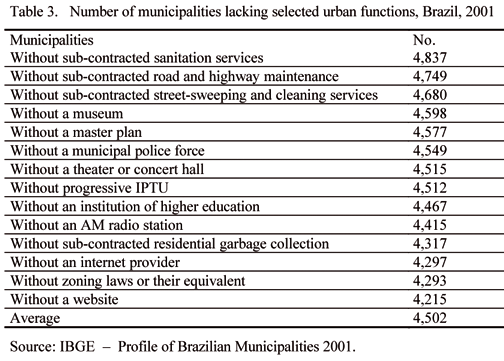
It would even be possible to believe that, in 2001, an authentic urban center had no website or Internet provider, offered no form of higher education and only listened to FM radio. But surely it is absurd to call cities municipal centers without zoning laws, master plans, residential garbage collection, progressive IPTU (property tax), street cleaning and road and sewer maintenance services (not to mention museums or concert halls). Is it just coincidence that these municipalities are sparsely inhabited and distant from the large population centers?
Even though this hierarchy of five ranks allows us to conclude that rural Brazil is concentrated in around 4,500 municipalities, containing slightly more than 30% of the total population, this is still insufficient to form a clear picture of the country's territorial configuration. In order to do so, it would be better to examine the hierarchy of its micro-regions.
It is easy to see that the 12 metropolitan agglomerations have a direct effect on 22 micro-regions, that the 37 other agglomerations similarly affect 41 micro-regions and that the 77 urban centers are located within 75 micro-regions. It is substantially more difficult, however, to establish distinctions within the other 420, i.e. 75% of the micro-regions. The inevitable question now is – what is the best criterion for classifying this myriad of micro-regions without a single real urban center? Probably there will never be a consensual response to this question, as it depends on inevitable assumptions, which determine the construction of any typology. Therefore, it is crucial that such assumptions are clearly explained when justifying the adopted criterion.
It is assumed here that demographic density is also a reasonable criterion for differentiating these micro-regions. Therefore. in the exercise which follows, the same cut-off – 80 inhab/km2 – to separate those micro-regions lacking a single urban center has been adopted, i.e. separating the 420 micro-regions distant from the agglomerations and urban centers into two categories according to this density ratio. Table 4 shows such a typology.
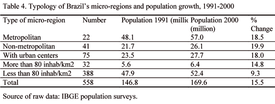
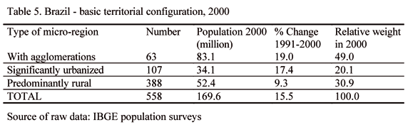
The final column of this table shows, however, that the populational behavior of the fourth type (micro-regions without an urban center, but with more than 80 inhab/km2) is closer to that of the preceding types (urban centers and agglomerations). Or rather, these 32 micro-regions clearly show a significant degree of urbanization, even though lacking a municipality with more than 100,000 inhabitants, the criterion used by the Ipea/IBGE/Unicamp study to define urban centers. It would seem more reasonable, therefore, to stratify the five micro-region groups into three major categories only: a) with an agglomeration (metropolitan or otherwise); b) significantly urbanized (with an urban center or with more than 80 inhab/km2); and c) rural (no agglomeration, no urban center and less than 80 inhab/km2). Table 5 summarizes the results of this exercise, showing that Brazils rural population accounted for around 30% of the total in 2000, virtually identical to the ratio arrived at from the previous, municipality-based approach. What does seem to vary is the weight of the other categories, depending on the criteria used to stratify urban Brazil. In both cases, however, rural Brazil accounts for around 30% of the population.
It is essential to emphasize that the use of this trichotomy to visualize Brazil's territorial configuration is based on a hierarchy that combines various structural and functional criteria. One begins by recognizing that agglomerations form a clear category – both in structural and functional terms – and that this is a suitable criterion for defining the top of the hierarchy. The opposite extreme is defined by the least anthropic pressure, reasonably evidenced by population density and, to a certain extent, lower population growth. Finally, the intermediate category comprises those micro-regions whose degree of urbanization is ambiguous or (which comes down to the same thing) which are relatively rural.
By opposing those areas exhibiting the greatest degree of ecosystem artificialization to those with the least anthropic pressure, the trichotomous approach avoids an ingenuous practice that is as frequent as it is misleading – relying exclusively on the criterion of municipal size. In Mexico, for example, Indesol (the National Social Development Institute) separates municipalities into four categories defined solely by population size, classifying all municipalities with over 50,000 inhabitants as urban; those with between 10,000 and 49,999 inhabitants as semi-urban; those with between 2,500 and 9,999 as semi-rural; and those with less than 2,500 as rural. However, a small municipality with a few thousand inhabitants, but adjacent to an agglomeration, may be substantially more urban that one with a much larger population, but with a lower density and distant from any agglomerations or urban centers. Even so, it is still surprising that 61% of Mexican municipalities fall into the rural category and 19% into the semi-rural one.
Finally, the criterion of population size does not come close to reflecting the most important issue – the ecosystemic changes provoked by mankind. And estimates are already available that allow us to include yet another dimension – the spatial one – to this estimate of the relative importance of rural Brazil. Table 6 compares continental data with those of Brazil.
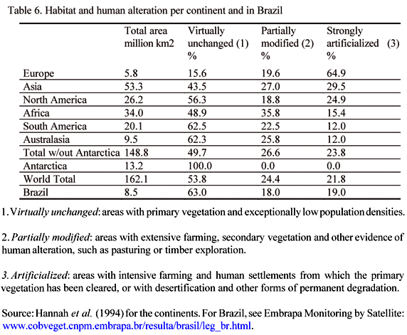
The first observation to be made refers to the contrasting degrees of ecosystemic artificialization in Europe and the rest of the world. Around 65% of European territory has been intensely modified (by both human settlements and intensive farming). In the other continents, the ratio is less than a third, reaching its lowest level of 12% in South America and Australasia (excluding Antarctica). Secondly, it is important to note that 50% of the Americas and Australasia are classified as virtually unaltered, areas that maintain their primary vegetation and where population densities are exceptionally low. Finally, we can say that half of the planets landmass remains virtually unchanged and over a quarter has been partially modified with extensive forms of primary exploration. Thus only a quarter of the global surface has been artificially altered by urbanization and the most intensive forms of farming.
Information provided by Embrapa Satellite Monitoring shows that Brazil's division according to these three levels of human alteration is midway between the situations in North and South America. The indisputably artificial areas (urban and farming) make up less than 20% of the total. Another 18% falls into the intermediate category, comprising mosaics of modified vegetation and other forms of ultra-extensive crop farming and pasturing (but also with areas of bare rock and soil, sparse vegetation and water bodies). The other 63% comprises rain forest (43.2%), dry forest (6.4%), forest subject to flooding (1.7%), transitional forest (2.9%) and plains or savannah (8.6%).
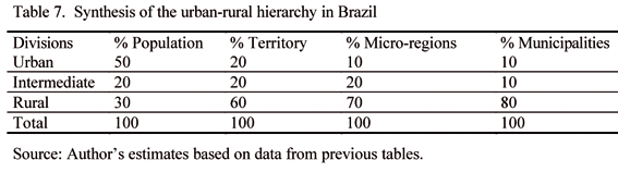
Finally, joining all these observations on the territorial configuration of Brazil, we arrive at the synthesis in Table 7.
Theoretical-historical implications
Although the urban-rural divide began to dissolve in Europe as of 1180, the dichotomy did not lose its cognitive power until the end of the 20th century, when basic differences (e.g. sanitary) between city-dwellers and non-city-dwellers began to disappear (at least in the handful of countries where capitalism had really developed). Today, such differences may remain in the underdeveloped countries, but are no longer so marked in the emerging nations, i.e. those not yet developed, but which cannot be grouped among the majority of countries making up the so-called "South".
As we have seen, the alternatives to the divide consist of classifications which do not eliminate its constituent poles. They may, in fact, be even more dichotomous, by subdividing the original categories into two more, as the ERS/USDA has done by mixing urban/rural with metro/non-metro, or as happens in Mexico with the notions of semi-urban and semi-rural. They can also be uneven, as with the exercises on Brazil presented here, which adopt three or five hierarchical strata. However, none of the various empirical approaches to territorial configuration has been able to ignore the urban/rural contrast. It seems as if the dichotomy resists all attempts to overcome it, remaining omnipresent despite criticism and rejection.
Herein lies a basic question of logic. A dichotomy is a division into two branches or the division of one genus into two species that encompass the whole. It is a system of classification whereby each thing or proposition is divided into two, which are then subdivided into two more, ad infinitum. Contradiction is not a subdivision but an opposition between two ideas or two propositions. Common sense tells us that whenever two contradictory propositions are opposed, one must necessarily exclude the other. In this sense, therefore, contradiction and dichotomy are synonyms. If dichotomy is a division into two branches, each excludes the other; ergo, a contradiction.
The notion of contradiction, however, has always meant something very different in western philosophy, at least since the time of Heraclitus – around 2,500 years ago – who resolved what had until then been regarded as a great mystery. For him, the world had to be understood precisely through the unity of opposites, a thesis which would only gain greater consistency with Kant and Hegel less than two hundred years ago. In the 20th century it generated profuse and confused debate – still far from over – on the so called Marx/Hegel relation and its effects on Marxism and its decline. A deeper analysis of this issue is beyond the scope of this paper, but more interested readers will certainly benefit from a comparative consultation of three books recently published in Brazil: Tambosi (1999), Giannotti (2000) and Holloway (2003). This does not prevent us, however, from briefly addressing the subject from the distinct point of view proposed by Nicholas Georgescu-Roegen (1971), who undoubtedly contributed most to clarifying what Marx referred to as the "metabolism" between human beings and nature.
We must remember that many concepts can be discretely differentiated, using discretely in the mathematical sense of the term. There are no gray areas between the concepts of a circle and a square – they simply do not overlap. However, this is not the case with squares and rectangles. It is almost impossible to determine with certainty whether a true rectangle is in fact a true square. Moreover, the square is "one" in the realm of ideas, but "many things" in the realm of the senses. Even the concepts of life and death are no longer binary opposites since biologists have confirmed that certain viruses/crystals exist in a shadowy realm between life and the inanimate. Almost all the great concepts involving judgment or which are themselves values (such as justice or democracy) belong to the second category. As Georgescu-Roegen says, there are no "arithmomorphic" frontiers between them, as they are surrounded by a penumbra in which their opposites overlap. He calls these "dialectical" concepts, emphasizing however that his approach is very different from those of Hegel and Marx, even though clearly inspired by the logic of the former. We do not need to stretch this logic to affirm that the ideas of urban and rural are of this type, even if they really were "arithmomorphic" in the Europe of the 10th and 11th centuries.
As a movement of opposites, the urban-rural relationship evolved so much in the most advanced countries that the great Marxist philosopher and sociologist Henri Lefebvre argued in the 1970s that post-industrial society would be completely urban. Or rather, that the rural pole of the contradiction would tend to disappear. However, more recent trends indicate how mistaken it is to treat 'rural' as being synonymous with 'agrarian', which was Lefebvre's basic error. Now, the principal advantages of the rural economy lie in such attractions as landscape (untouched or cultivated), fresh air, fresh water, silence, tranquility etc., so much valued by the elderly, tourists, sportspeople, politicians and certain businessmen (Galston and Baehler, 1995).
Clearly, the quality of life in any location depends on the residents' access to jobs, essential social services, educational and medical facilities, a wide range of cultural and commercial services and nature itself, i.e. open spaces for recreation. For all these criteria, except the latter, such access is normally greater in the huge metropolitan complexes. On the other hand, the negative aspects of population concentration – time lost in transport, traffic congestion, unnecessarily large and impersonal public service outlets, stress, individual and group alienation and pollution – are regarded with increasing discomfort (Pred, 1979).
Moreover, economic growth cannot be based for much longer on the extraction of the low entropy found in coal, gas and oil. Soon it must be based on more direct forms of solar energy, especially biomass. We cannot imagine future forms of entropic compensation without considering that biotechnology will play a crucial role in producing both an increase in biomass productivity and an expansion in the range of its products, normally referred to as the "4-Fs" (food, fuel, fertilizers and feedstock). If we are to develop into a modern, biomass-based civilization, it will be absolutely crucial to develop a feasible "green chemistry", initially as a complement to, but finally substituting, the petrochemical industry, replacing fossil fuels with biofuels. (Sachs, 2002).
When one considers the need to conserve biodiversity, one normally thinks of the most endangered species and the loss of genetic information that their extinction would bring. However, this is by no means the only type of damage resulting from a reduction in biodiversity. Indeed, it is not even the greatest one; worse by far is the systematic weakening of our ecosystems that makes them vulnerable to shocks, i.e. a diminished capacity to cope with, or recover from, catastrophes or destruction brought about by human societies. This is known as resilience – the ability to overcome the disorder caused by external phenomena (Dasgupta, 2001: 127-131).
In short, there are many reasons to affirm that rurality, far from being suppressed by total urbanization (as many would suppose), is in fact gaining considerable strength. In the most advanced countries nowadays, the amenities that are fueling the new provincial dynamism are rural ones. The sources of low entropy and biodiversity which future generations will depend on are also rural. Indeed, the value of the rural space is becoming increasingly tied to precisely those things that distinguish it from the urban one.
Conclusion
Brazil is much more rural than the official calculations would have us believe – in fact, no less than 80% of its municipalities and 30% of its population belong in this category. This is by no means a negative attribute, given that many of the main competitive advantages of the 21st century will depend on the strength of rural economies. These are the two main conclusions we can draw from an analysis of the countrys current territorial configuration, bearing in mind the most recent indicators on the future of rurality in the most advanced human societies. In doing so, it is necessary to overcome the dichotomous approach, but without falling into the trap of believing that the historical urban-rural contradiction is disappearing.
Bibliography
Champion, Tony and Hugo, Graeme (eds.). New forms of urbanization: beyond the urban-rural dichotomy. International Union for the Scientific Study of Population (IUSSP) e Ashgate, 2003.
Cipolla, Carlo M. Before the industrial revolution; European society and economy 1000-1700. Londres: Routledge, (3rd edition), 1993 [c1976] .
Dasgupta, Partha. Human well-being and the natural environment. Oxford Univ. Press: 2001.
Davidovich, Fany R. e Lima, Olga M.B.. Contribuição ao estudo de aglomerações urbanas no Brasil. Revista Brasileira de Geografia, Rio de Janeiro, vol. 37, no.1, 1975.
Duby, Georges. Guerriers et paysans; VII-XIIè siécle; Premier essor de l'économie européenne. Paris: Gallimard, 1973.
Embrapa Monitoramento por Satélite: http://www.cobveget.cnpm.embrapa.br/resulta/brasil/
ERS/USDA – Economic Rural Service, United States Department of Agriculture: http://www.ers.usda.gov/briefing/rurality
Galston, William A. e Baehler, Karen J.. Rural development in the United States; Connecting theory, practice, and possibilities. Washington, D.C.: Island Press, 1995.
Georgescu-Roegen, Nicholas. The entropy law and the economic process. Cambridge, MA: Harvard University Press, 1971.
Giannotti, José Arthur. Certa herança marxista. São Paulo: Companhia das Letras, 2000.
Hannah, L., D. Lhose, C. Hutchinson, J. Carr e A. Lankerani. A preliminary inventory of human disturbance of world ecosystems. Ambio. 23 (4-5), 1994.
Holloway, John. Mudar o mundo sem tomar o poder. São Paulo: Viramundo, 2003.
IBGE. Atlas do Censo Demográfico 2000. Rio de Janeiro: IBGE, 2003.
IBGE. Perfil dos Municípios Brasileiros, Gestão Pública, 2001. Rio de Janeiro: IBGE, 2003.
Indesol – Instituto Nacional de Desarrollo Social. Perfil y perspectivas de los municipios mexicanos para la construcción de una política social de Estado. México, DF: 2002.
Ipea/IBGE/Nesur-IE/Unicamp. Caracterização e tendências da rede urbana do Brasil. 2 v., Campinas, Unicamp, 1999.
Ipea/IBGE/Nesur-IE/Unicamp. Caracterização e tendências da rede urbana do Brasil. 6 v., Brasília: Ipea, IBGE, Unicamp, CEF and Finep, 2002.
Lefebvre, Henri. A revolução urbana. Belo Horizonte: Ed. UFMG, 2002 [c1970] .
OCDE – Organization for economic co-operation and development. Territorial indicators of employment; Focusing on rural development. Paris: OECD, 1996.
Pred, Allan. Sistemas de cidades em economias adiantadas. Rio de Janeiro: Zahar, 1979.
Sachs, Ignacy. Caminhos para o desenvolvimento sustentável. Rio de Janeiro: Garamond, 2002.
Tambosi, Orlando. O declínio do marxismo e a herança hegeliana. Lucio Colletti e o debate italiano (1945-1991). Florianópolis: Ed. UFSC, 1999.
