


Mi SciELO
 Servicios personalizados
 Inglés (pdf)
 Articulo en XML
 Referencias del artículo
 Enviar articulo por email
 Citado por SciELO

 Permalink
Estudos Sociedade e Agricultura
versión impresa ISSN 1413-0580
Estud.soc.agric. v.1 n.se Rio de Janeiro 2005
An analysis of the regional impacts of land reform in Brazil1
Análise dos impactos regionais da reforma agrária no Brasil
Beatriz HerediaI; Leonilde MedeirosII; Moacir PalmeiraIII; Rosângela CintrãoIV; Sérgio Pereira LeiteV
IProfessor at UFRJ/IFCS [Federal University of Rio de Janeiro/Institute of Philosophy and Social Sciences]
IIProfessor at UFRRJ/CPDA [Rural Federal University of Rio de Janeiro/Postgraduate course in Development, Agriculture and Society]
IIIProfessor at PPGAS /Museu Nacional/UFRJ [Postgraduate programme in Social Anthropology/National Museum/Federal University of Rio de Janeiro]
IVResearcher
VProfessor at UFRRJ/CPDA [Rural Federal University of Rio de Janeiro/Postgraduate course in Development, Agriculture and Society]
Translated by Miles Forest
Translation from Estudos Sociedade e Agricultura, Rio de Janeiro, n.14, p.73-111, Apr. 2002.
ABSTRACT
This article aims to portray short, medium and long-term change processes brought about by the establishment of rural settlements in Brazil. The goal was to apprehend the transformations in the lives of the settlers, in the settlements and in the regions where these are located. The article is based on a study that carried out in some of the Brazilian regions that had the greatest concentration of settlement projects and number of families of settlers per unit of territory (termed zones). The basic premise was that this concentration stemmed from struggles, and that the proximity of several projects has served to multiply their effects.
Key words: land reform, rural settlements, struggle for the land.
Introduction
Though a great deal of research on rural settlements in Brazil has analysed internal conditions, related policies and the progress of settlers, few studies have examined the importance of the implementation of rural settlements for the regions in which they are located. This article tackles this issue by identifying the processes of change that the rural settlements have brought about in their local settings.1
The term "impact" may perhaps be an exaggerated way of expressing these changes, for it brings to mind that which is most evident and spectacular, when in reality the changes are often subtle and only lead to observable results over time. The magnitude and characteristics of these changes depend on different contexts – local, regional and nationwide – so a linear pattern should not be sought in this transformation process. The creation of the settlements results in short, medium and long-term changes whose effects are felt both within the projects – on the lives of the settlers – and outside of them. Far from assigning them a negative or positive value, stating successes or failures, our analysis is designed to measure and characterise the changes, with the aim of creating indicators and identifying relationships that reflect the meaning of these experiences by comparing the current and previous situations of the settlers (both objectively and subjectively), as well as by comparing the social and economic conditions within settlements to those in the surrounding areas. Moreover, the effects brought about by local and regional projects are analysed.
In broad terms, the impacts of the settlements must discussed with regard to multiple relationships, in which different avenues lead to different results. Thus, hasty generalisations should not be made. Rather than identifying impacts, it is necessary to analyse the economic, political and social effects of the transformation processes triggered by the creation of the settlements. The pace and intensity of these processes vary, and have a bearing not only on the families of the settlers but on the rest of the local population as well.
Methodological aspects and characterisation of the sample
The focus of this study was a given set of Brazilian regions with a large concentration of settlement projects and a great density of settled families per land unit, based on the assumption that this would increase the chances of understanding the change processes underway. These regions were given the label zones, and their geographic location does not necessarily coincide with other existing regional sections – as defined by the Brazilian Institute of Geography and Statistics (IBGE), by the state governments, by the National Land Colonisation and Land Reform Institute (Incra) or by social movements. The defining criteria was the existence of a set of neighbouring municipalities with a relatively large concentration of settlements, in terms of number of projects, families, and occupied areas, considering the historical, economic, social and organisational dynamics they have in common. Six large zones were chosen, reflecting the diversity of Brazilian realities: the Federal District and surrounding areas, the North-eastern Sugar Cane Region, the Sertão (semiarid region) of the State of Ceará, Southern Bahia State, South-eastern Pará State and Western Santa Catarina State.2 Sample zones were chosen, within each one of these greater zones, which contained groups of municipalities that had the largest concentrations of projects and the greatest proportion of settlers as compared to the overall rural and urban populations.3 Questionnaires were applied to carry out a detailed analysis.
The settlements analysed were implemented by Incra from 1985 to 1997. The starting date was based on the initial implementation of the National Land Reform Plan (PNRA), which represented the turning point of settlement policies that had until then remained similar to those of colonial times. The year 1997 was chosen as the end of the study period because we believed that a timeframe of 12 years would be the minimum amount of time the projects would take to have an observable impact. Table 1 shows some data on the sample utilised.
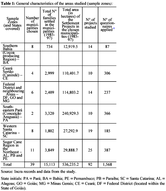
Though the selected zones all have higher concentrations of settlements than the other parts of the states (oftentimes one-third or more of the state-wide number of settlements), the participation of the projects (whether in terms of occupied area or number of families of settlers) in the municipalities and zones studied varies considerably. This factor, coupled with the fact that the dynamics of the respective regions differ, and that some settlers have greater organisational capacity than others, explains the large variation between the effects produced by different settlements.
It is noteworthy that the sample is statistically representative only of the chosen municipalities (sample zone), and not of whole regions, not to speak of the whole country.
The beginning of the zones and the land distribution processes of the land reform
The structure of the zones, contrary to the rationale of isolated expropriations which characterises past government interventions in land issues, is in itself a relevant aspect of the changes the settlements have caused upon the regions where they are located.
The Land Statute was the first legal measure to establish a process of intervention and expropriation and to make it possible to designate "priority land reform areas", but these did not come to fruition under the military regime. This scenario began to change with the re-democratisation process, in 1985. The whole idea behind the PNRA, based on the Land Statute, was to establish priority areas for land reform. However, the reaction of anti-reform thinking led to this idea being abandoned.
From then on, only unplanned expropriations were carried out. They were indeed more frequent than during the time of the military regime, and occurred as a consequence of the social struggle and mobilisation which developed at a greater pace after the oppression diminished. Although the measures which resulted in the establishment of settlements during the democratic period were not designed to attain the "massive" land reform that the labour movements demanded, they were the result of the pressure put on by these movements. Furthermore, they gained leverage by the fact that there was a certain degree of simultaneity (due to the "expropriation packages") and that they were concentrated in the regions in which the movements were active, though these did not always reach adjoining areas. The perceived success of this course of action stimulated workers in neighbouring areas, and new expropriations were carried out, so settlements spread in some areas and the movements tried to repeat this experience in other areas. This was how the "reformed areas" appeared afterwards.
An analysis of the information on the existence of conflicts and on the initiative for expropriation requests reveals a close relationship between the initiatives of the rural workers' movements and the expropriations. Almost all of the settlements studied (96%) had conflicts. In 89% of cases, the initiative for expropriation requests came from the workers and their movements. In this sample, only 10% of the settlements resulted from an expropriation initiative on the part of Incra.5
Although the workers' initiatives have taken on many different forms (sometimes involving a combination of strategies and sometimes changing over time in a given place), as Table 2 shows, 64% of the settlements studied were the result of "land occupation". The "land resistance" tactics also played an important role, and was responsible for almost one third (29%) of the settlements studied.
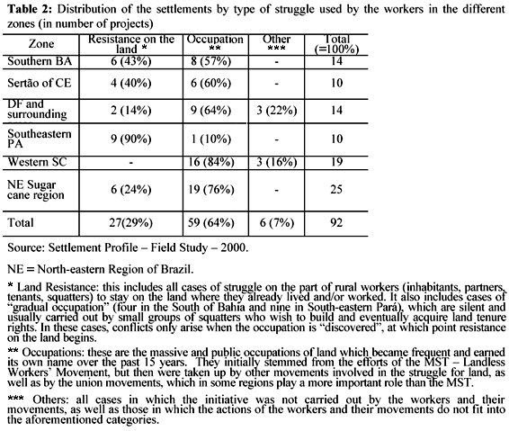
The analysis of the zones in the State of Santa Catarina reveals that, with the exception of three population resettlements carried out by Incra, the establishment of settlements were the result of the land occupation. Land occupation is also prevalent in the Federal District and surrounding areas, Southern Bahia and the Ceará Sertão, though land resistance also plays an important role in the two latter zones, as do the gradual occupations in the State of Bahia. In the South-eastern Pará zone, all but one settlement studied arose from "gradual occupations", where the initiative to enter lands was taken by the workers themselves. The support of mediators (rural workers' unions and the CPT – Pastoral Land Commission) only became necessary when the land owners began to retaliate with threats, pressure, and the direct violence of gunmen or the police. These conflicts usually went on for long periods of time.6 In the Sugar Cane Region in North-eastern Brazil, many of the occupations (11 of the 19 cases) were related to other forms of struggle, such as the continuation of resistance by local inhabitants or small partners and tenants to being expelled from farm and sugar mill lands, and recent claims (workers' compensation paid with land plots) by the employees of bankrupted mills. The use of occupation as an instrument in this struggle became widespread in the nineties, and prior sugar mill workers and unemployed inhabitants of the small cities were able to take part in these occupations.
As mentioned previously, the settlements studied were established between 1985 and 1997. An analysis of the time distribution of the implementation of these projects will show an unequal distribution: 25% of the projects were started between 1985 and 1989, a mere 8% from 1990 to 1994 and 67% from 1995 to 1997 (cf. Table 3).7
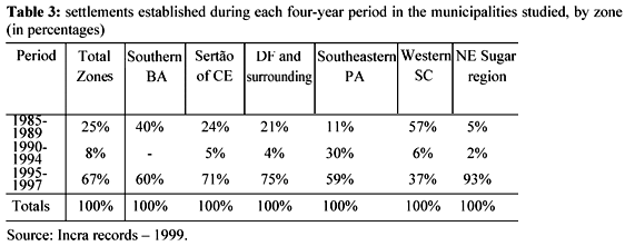
This variation could plausibly be attributed to the different political stances on land reform during the successive Brazilian governments. The drop between 1990 and 1994 may be explained by a delay in regulating constitutional norms, which were only regulated in 1993. However, the percentage distribution in the establishment of settlements in the 1985-1989 and 1995-1997 periods tends to coincide with a change in the distribution of forms of struggle used by the workers, with resistance on the land in 29% of the cases and occupations in 64% of them. This would indicate that the cause of this variation lies not so much in the differences between government policies as in the types of conflicts that prevailed during each period, with the hegemony of one or another type of struggle. This lends support to the opinion that the initiatives of the workers are the true driving force of the expropriations.
A careful analysis of the variations in the overall pattern in each zone studied strengthens such a point of view. The drop in the number of new settlements during the 1990-94 period occurred in all but the Pará zone. There was also an increase in number of settlements during the 1995-97 period in all zones except for Santa Catarina. South-eastern Pará is the only zone in which there was a rise in the number of settlements between 1985 and 1997, and this trend occurred in the whole State of Pará, as well as in all of Northern Brazil. This privileged situation in the Amazon Region is due to a combination of factors: the pressure put on by those who struggle for possessing land, the old idea of colonisation as an alternative to land reform (defended by the military governments and by some ministers of the democratic period), and the perspective of good farming business with the expropriation, by Incra – at or above market value – of land that was once public and was purchased by private parties at extremely low costs.
The large number of settlements established in Santa Catarina during the first period was due to the massive occupation of land in the Western part of the State by the MST and by some rural workers unions, with the support of the CPT, when the PNRA was proposed. This mobilisation put the State among the leading states in number of expropriations and settlements during the first two years of the Sarney Administration, despite the fact that Santa Catarina has the Country's lowest land ownership concentration.
Another striking situation is that of the Northeastern Sugar Cane Region, which has been renowned for its social strife since the mid fifties, as the focal point of active rural worker movements. This zone had an extremely small number of expropriations and settlements during the 1985-89 period. The great leap only happened after 1995. The new situation that explains this distribution over time is the unprecedented crisis the sugar cane industry has undergone since the second half of the eighties. Over the past years, more than 15 mills have closed down in Pernambuco without paying their debts – including those owed to their employees. Land occupation, which until recently had been scarce, in the wake of MST actions has become the main fighting instrument for the rural workers to deal with the crisis.
However, the social movements, as well as other players in the social struggle, have been subjected to and have also acted upon a set of conditions occurring at this particular moment in history which have led to an increase in the number of settlement projects in the zones studied. Namely, the rise in the cost of land and the great flux of immigrants into the Federal District and surrounding areas; the crises of cocoa farming in the South of Bahia, of sugar cane farming in the Northeast and cotton farming in the Ceará Sertão – which became worse with the recent intense droughts; the difficulty in reproducing small farming in the South of Brazil; and the bankruptcy of large enterprises sponsored by the Government in South-eastern Pará.
The regional concentration of settlements is thus the objective result of a battle waged by the different players who fought for the repossession of the land and the rationalisation of its use. In the confrontations, workers' movements have been able to define "priority areas" for government intervention and have been hegemonic in the design of models for settlements, i.e. patterns of social relations. Though these may not attain the ideal goals proposed by the movements, they are at least much closer to the values of the "peasant culture" than to those of government planners.
Presence of the settlements in the regional, political and social dynamics
The settlers and their families
Large part of the population of settlers already lived in the same rural areas where they are now before they moved into the settlements: over 80% of those studied in the sample came from the same municipality or from municipalities that are near the settlement. Ninety-four percent of them had already had some sort of experience with farming.
An analysis of the type of work they carried out immediately before going to the settlements shows that 75% of the settlers were previously employed in farming activities, as permanent or temporary rural paid workers, squatters, partners, land tenants or as unpaid family members.8 The chief occupations in each zone clearly reflect the land problems described above. In Southern Bahia, permanent paid rural workers – probably former paid cocoa plantation workers – predominate (45% of the settler population). In the Ceará Sertão the majority are unpaid family members (58%), which is the prevalent form in the whole North-eastern Brazilian Sertão. In the Federal District and surrounding areas and in the North-eastern Sugar Cane Region, temporary and permanent paid workers predominate (more than 40%), followed by squatters/partners/land tenants, which indicates that the population used to live subordinated to the farms. In the South-eastern Pará zone, the predominant form is non-earning family members (43%) and squatters (11%). The latter may possibly be due to the fact that the settlers are offspring or relatives of squatters from older areas of occupation. In Western Santa Catarina, 44% were partners/land tenants, and 14% were unpaid family members (farmers' offspring), which reflects the current family farming crisis in that State.
As to the level of schooling of those responsible for the plots of land, the overall results for the zones show that 87% of them did not attend school past fourth grade, and 32% never went to school at all. Only 2% of them attended beyond eighth grade. The data for the settlers' spouses and other members of the population of settlers over the age of thirty are similar.
Thus, the settlements have made possible land ownership to a population that has historically been excluded and that, even in cases in which they were somehow incorporated into the work market, did so in unstable and precarious conditions.
The people who go live on the settlements do not do so alone: most of the holders of land plots move in with a family. In general, the family formations on the plots are similar to those on common family farms, with a nuclear family (mother, father and children) who find in the settlements an important source of work and conditions for social and economic development.
There are children on more than 80% of the plots, mostly under the age of 14. The average number of children is three per family.9 In many cases (24%) the families also live with other relatives, such as parents, in-laws, sons, daughters, siblings, grandchildren and so forth. In most cases, they did not live with the nuclear family before moving into the settlements but were incorporated into the family unit,10 which implies the settlements have played the role of reuniting families. This contributes both to re-establishing family ties (formerly severed or threatened because sons, daughters, parents or siblings had to leave the family household in search of means for survival), and to give shelter to the relatives.
Moving into a settlement does not only involve isolated families (with or without added relatives), but also extended family groups: 62% of settlers have a relative who lives on another plot in the same settlement. Thus, the settlements seem to group together (or regroup) segments of communities, if not whole communities.
In the case of settlements in which a significant part of the settlers belonged to families that already lived in the expropriated area, the implementation of the projects not only makes it possible to maintain existing relationships; oftentimes it also leads to a rearrangement of the families (as new neighbourhood ties are formed), which fosters the coexistence of people who were strangers or near strangers, thus producing new opportunities for meeting, sharing and determining new forms of organisation.
The settlements and their internal organisation
The locality and size of the settled areas are usually a random occurrence, because they are the result of conflicts that extend over time, and because they depend to some point on the features of the agrarian structure. The set of zones can be divided into three groups based on the total area of the projects and on the number of families of settlers.
The first comprises South-eastern Pará, the Federal District and surrounding areas, and the Ceará Sertão, where most of the settlements are characterised by large tracts of land and a large number of families (more than 60% of the projects with areas of at least two thousand hectares and over fifty families). The second group includes Southern Bahia and Western Santa Catarina, where the settlements tend to be smaller and have fewer families (most of them with less than 1,000 hectares and fewer than 50 families). The third group is the North-eastern Sugar Cane Region, where small tracts of land are occupied by large numbers of families, which reflects a greater rural and urban population density (more than 60% of the projects with less than 2,000 hectares and more than 50 families).11
The mean area of plots in the whole sample is 35.5 hectares, but this varies greatly between zones, ranging from 7.8 hectares in the North-eastern Sugar Cane Region to 72.6 hectares in South-eastern Pará. There is a clear-cut difference between Southern Bahia, Western Santa Catarina and the North-eastern Sugar Cane Region, on the one hand, where the average settlement size is greater than 2,000 hectares and plots are smaller than 20 hectares; and, on the other, South-eastern Pará, the Federal District and surrounding areas, and the Ceará Sertão, with settlements larger than 8,000 hectares and an average plot size of more than 30 hectares.12
The internal physical organisation of the projects on the most part seems to obey a certain pattern that already existed among the local family farmers before the settlements were established, but some innovations did take place.
In most of the units studied the houses are located on the plots. Farming communities were found in almost one-fourth of the projects (most of them in Southern Bahia and in the Sugar Cane Region), usually coexisting with population groupings that existed before the settlements were established. In the Ceará Sertão zone, there are communities (different-sized groupings of settlers' houses) surrounded by subsistence croplands. The pastures are often collective. In the larger projects, each community has an association, which organises the economic activities of its members, and the whole settlement has one central cooperative that co-ordinates the associations. In the South-eastern Pará zone, although most of the houses are on the plots, since the occupation of the areas led to the foundation and/or expansion of villages. In some cases these are becoming villages with small commercial and service-providing centres, which attract other people besides the settlers. In the Santa Catarina zone the houses are on the plots, and the communities (a sort of rural neighbourhood) follow the local pattern and may precede the settlements or be formed as a consequence of them. One new form of organisation is that of the núcleos (centres), which are political and organisational divisions within the settlements that were proposed by the MST for the discussion of problems and demands made to the Government. In the North-eastern Sugar Cane Region zone, places where there were old mills or farms became meeting places for economic or political initiatives of the settlers and, in some cases, farming dwellings built by Incra.
Demographic and land impacts
The rural settlements in this study did not radically alter the scenario of land ownership in this Country, nor in the States or regions in which they are located, therefore the rural settlement policy cannot be considered a profound land reform process.
In the States studied, a comparison of the total area of rural settlements established by Incra up to 1999 (excluding the settlements implemented by the State governments) with the total area of farming and cattle ranches listed in the 1996 census, reveals that except for in Pará, the area of the settlements ranges from 0 to 5% of the total area.
Nevertheless, in the Sample Zones studied, the ratio of settlement area to farming area in the municipalities is significantly greater, which indicates a territorial development process in the land reform. As shown in Table 4, there are important variations between the zones (and even between the municipalities that compose a given zone), going from a mere 3.1% (1999 data) in the Southern Bahia zone to 40.39% in the South-eastern Pará zone. This means that although the impact may seem modest at the state level, it tends to be meaningful in the chosen areas, especially in certain municipalities in which it increased significantly between 1997 and 1999.
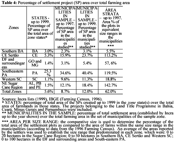
The last column in Table 4 shows an approximation of the impact of the settlements on land distribution in comparison with other classes of land tracts within the same size range as the settlers' plots. It indicates that there was a significant impact13 on some zones, such as the Ceará Sertão, South-eastern Pará and the North-eastern Sugar Cane Region, where the total area of the settlements was greater than the area occupied by other farm lands in the same size stratum at the time of the IBGE census14. Consequently, although the implementation of the settlements has not altered the scenario of land distribution on a large scale, it has produced a significant redistribution at a local level.
As to the demographic impact, the settler population has caused a significant increase in the rural population of the municipalities, but not in the population of the regions as a whole. One possible inference is that, with some exceptions, the increase in settlements has contributed to detain the migration of the rural population to the cities, if not to reverse it. In municipalities with few inhabitants, the settlement population is important, even when compared to the urban populations.15
Access to public policies and infrastructure conditions
In general, the infrastructure of the settlements in the zones studied is quite faulty, in keeping with the substandard conditions found in most Brazilian rural areas. However, this does not mean that nothing has changed; the creation of the settlements and the expectations of those involved necessarily give rise to a number of demands and claims, which are successful depending to the extent to which settlers can organise themselves and the local political state of affairs.
The initial stages of arrival in the settlements (in cases where the population did not already live in that area) are quite difficult, because everything needs doing on the plots, including the houses. For the families to have minimum starting conditions for their social, economic and productive integration, they need to have access to credit. Incra offers three different forms of credit: development, housing and food. In the settlements studied, 81% of the families were benefited with development credit, 72% with housing credit and 74.63% with food credit, which represents a reasonable amount of coverage.
This data must be interpreted taking into account the fact that this credit takes a long time to be granted. Delivery of the development and food credit took an average of nine months, counting from when the projects were officially created. The housing credit took over two years (28 months on average), which made the beginning stages more difficult and undermined the families' capacity to carry out their activities.16
Questioned about their current and past housing conditions, 79% of the settlers reported an improvement. Answers varied between regions. On average, only 8% of the settlers stated that their situation had become worse. Official figures regarding types of buildings match these opinions: 74% of the settlers' houses in the studied zones are made of brick or cinderblocks, as opposed to 39% - in the best of cases – of their previous houses. Credit disbursement and the changes in types of houses also served to foster local commerce (because of the demand for construction materials) and the labour market (construction work).
With regard to the water supply, most settlements studied had problems due to the lack of water or bad water quality. In nearly 46% of them, interviewees reported there were plots that had problems with the amount of water available for production.
Seventy-eight percent of the projects have on-farm electricity, but only 27% have an adequate supply. In 66% of the cases studied, electricity was only furnished some time after the settlement had been established. In 53% of the projects that have electricity, the settlers reported making demands in order to obtain it.
Public telephone systems are scarce on the settlements: only 16% of the projects have any at all, which means that in a medical emergency, or when in need of basic commercial information, settlers must go elsewhere, sometimes at a great cost in terms of money, time and effort.
In the overall sample, the average distance from the settlements to the nearest city is 28 kilometres, which usually takes approximately an hour of travel.17 Roads leading to the entrance of the settlements are usually dirt roads (46% of the projects), or a combination of dirt and paved roads (34%). In the interviews, 70% of the settlers reported bad roads, half of which cannot be travelled during the rainy season. The condition of the roads within the settlements is even worse: in only 18% of the settlements studied are all of the plots accessible year round. Therefore, the settlers usually face difficulties getting around, especially during the rainy season, which further undermines their access to health and education and makes it harder to sell their products.
As to collective transportation, although the overall scene is quite bleak, field observations revealed that in several municipalities the presence of the settlements led to an increase in the number of town vehicles and machinery, such as school buses, ambulances and tractors. It also caused changes in the routes of bus lines and an increase in alternative services, such as motorcycle taxis and pickup trucks, which probably benefited neighbouring areas as well.
Data from the interviews show that one of the most serious concerns of settlers is whether or not there will be schools for their children. There are schools in 86% of the projects researched. Most of them were built after the settlement was already established (84%). This relatively large number of schools seems to have been the result of demands made by the settlers: in 71% of the cases it was necessary to fight for the construction of schooling facilities. Most settlement schools are maintained by the local authorities (87% of the projects). In fewer cases, they are set up, supported and even run by social movements (MST, rural workers' unions), in partnership with non-governmental organisations (NGOs) and the Government.
Living on a settlement seems to improve the chances of children going to school. A large percentage of the school-age population goes to school: around 90% of the children between the ages of 7 and 14, and 60% of the youths between 15 and 19. In a comparative assessment by the settlers interviewed who were asked to compare the current versus previous schooling situations, they acknowledged shortcomings but 70% considered it had improved, 20% that it had not changed much, and 9% that it had become worse.
On the other hand, the situation in terms of grade levels is not so favourable: 77% of the projects with schools have multiple-grade classrooms, and in 73% of them the schools only go up to fourth grade. Only 19% of the projects that have schools offer education up to eighth grade. There are no high schools or technical schools whatsoever. The level of schooling offered in the settlements seems to have an effect on the rates of school attendance: in 45% of the projects most of the children make it to fourth grade, in 13%, fifth grade, and in only 28% do they reach seventh or eighth grade. In the projects where there are no schools, the rates are even worse, and the children usually do not go beyond fourth grade. In this sense, the education offered to settlers is clearly insufficient (in quality and in level of schooling), and the levels of schooling are only a step above the low levels of the adult population.
There are also youth and adult education programmes in 64% of the cases studied. Most of them are sponsored by the National Programme for Education and Land Reform (Pronera)18 and a few by the local authorities. This has made literacy possible for part of the adult population on the settlements: in the projects studied 6% of the adults over 30 years of age attended these programmes. There is a lack of classrooms, however, and most of the courses only teach reading and writing, are short-termed, and offer no prospects for continuity.
As to the health services, though there is a meaningful number of community health workers (in 78% of the projects), there are only community health centres in 21% of the settlements studied, mostly built by pressure from the settlers. Even when there are medical facilities, there are usually no doctors on a regular basis.19 Given this bleak situation, most of the settlers seek health services in the same municipality (in 92% of the projects), in neighbouring municipalities (42%) or in cities that have general hospitals (25%).
This means that the establishment of settlements, especially when it involves populations from other municipalities or regions, puts a great deal of pressure on the health services, and it is a known fact that these already provide an insufficient level of health care as is. This tends to cause new demands or to add upon existing ones. Additionally, settlements are normally far from the urban centres and the access roads and/or collective transportation services are inadequate, which results in faulty health care for the settlers and has a serious effect on their lives.
The principles of association and political participation
Given the precarious infra-structure, coupled with the difficulties found in getting settled on the land and, in more general terms, in reproducing the family farms, the establishment of the settlements is not as much the end point of a process of struggle as the starting point for new social and economic demands. Their new situation forces the settlers into life experiences that they would hardly have encountered in their previous situation. They begin to get organised, establish dialogues with the Government, make demands, put on pressure, negotiate; in sum, they begin a number of activities that put them at the front line of political participation.
The study showed that in the various zones the presence of the settlements brought about changes in the relationships between the workers who live on them and the local authorities, either demanding new forms of action or strengthening traditional patronage systems (which are common in precarious situations) or empowering new leaders to run for public office.
Associations, present in 96% of the settlements studied, are a predominant form of organisation representing the settlers. Their existence is practically mandatory because they represent settlements legally and in formal connections with government departments and other agencies.
In fewer cases, broader associations and organisations were present in the settlements, including unions and municipal associations, regional, state or nationwide organisations such as the MST, other land struggle movements, and rural workers' union federations.
In some cases, settlers' representatives sat on municipal management councils (rural development, health, education and agriculture councils) or in municipal agriculture secretariats, or were candidates for local public office (Aldermen or mayors).
This data indicates that the political experience acquired in the struggle for the land (in whichever form it took place) ended up producing leaders and forms of representation, as well as lessons on the importance of different forms of organisation and their capacity to produce demands. Thus, the existence of the settlements has to some degree modified their local political scenarios.
The presence of the settlements within the dynamics of regional economies
Possibilities for work and job creation
In the current context of crisis in the farming sector and of difficulties in reproducing family farming, along with the fact that the labour market has become more and more difficult for the less educated segment of the population, the settlements in various zones provide an important source of employment and access to land tenure.
As mentioned, in the areas studied most of the settlement population comes from the same municipality or from neighbouring municipalities, and the plot owners have a low level of formal education and have previously had an unstable participation in the rural/farming labour market. With the establishment of the settlements, it has become possible for them to centre their family development and financial livelihood strategies on their own plot, combining the activities they carry out there with other activities related to the existence of the settlement.
In the total population above the age of fourteen in the projects studied, 79% worked only on the plot, 11% on the plot and also elsewhere, 1% only elsewhere, and 9% declared they did not work. This means 90% of the settlers over fourteen years old worked or helped on the plot. There was an average of three people per plot. Of those who did any type of work in other places (12% in all)20, 44% did so occasionally, 24% temporarily and 31% on a permanent basis. It is worth mentioning that of those who worked in other places, more than half (56%) carried out activities only within the settlement itself, which included non-farming work created by the implementation of the project (construction of roads and collective infra-structure, teaching, food and health services, collective work, product processing and so forth).
Although the settlements are evidently job creators, some of the settlers end up leaving (temporarily or definitively): 28% of the families in the settlements of the zones studied reported having had a family member leave the plot (there are regional variations, the highest percentage being that of the South-east of Pará (38%), and the lowest that of the North-eastern Sugar Cane Region (around 15%). Overall, forty-two percent of the departures are due to the need to search for employment and/or another land property (the highest percentage being 60%, in Ceará).21 In all, 12% of the plots in the settlements studied lost members who left in order to find employment elsewhere.
Farming production
The settlements produce a wide variety of products. Chart 1 shows the five top percentages, for each zone, of farm products cultivated, sold and considered important in the 1998/99 harvest. It also includes the five products that contributed the most to the plots gross production (GP).22
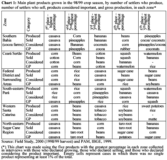
It is evident that there is not necessarily a match between the products most grown, sold, and considered important, nor between these and the products with the greatest GP. Corn, cassava and beans are clearly the most commonly grown products, as well as those considered important by the greatest number of settlers, with exceptions in some zones. This choice has strategic value: these products are easily sold and are crucial in the families' daily diet. They are followed by taro root, bananas and rice. Other mainly "cash crops", such as cotton, sugar cane, pineapples and tobacco, are also high on the lists.
The analysis of the share of different farming products in the overall GP (the only animal products included are milk and eggs),23 showed that milk, cassava, corn, beans, eggs, rice, pineapples, soybeans, taro root and cassava flour were in the top ten positions (which represent 78% of the GP). Of these, the first three account for 48% of GP and the first five for 61%.
Table 5 shows the top ten animal products raised, sold and considered important.
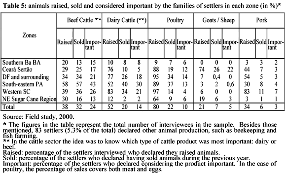
Both dairy and beef cattle are important in all of the zones except for Southern Bahia and the Sugar Cane Region. It is especially important in South-eastern Pará (sale of calves and milk production), Western Santa Catarina, and the Federal District and surrounding areas. Poultry for meat is considered important by many producers, but it seems to be reserved mostly for subsistence rather than commercial use (meat and eggs), except for in the zones in South-eastern Pará and Federal District and surrounding areas, in which they are also sold. Pork is common (except for in the Southern Bahia and Sugar Cane Region zones) and is almost exclusively used for subsistence. Goats and sheep are only considered important in the Ceará Sertão.
Gathering activities are important in some zones: piaçava palm, in Southern Bahia (where 44% of the interviewees produce and sell it) and matte in Western Santa Catarina (sold by 14% of the settlers and placed among the products with the greatest GP). Timber for fence posts is considered important in South-eastern Pará (17% declared selling) and firewood for charcoal in Western Santa Catarina. Other forest products mentioned as important for household use in different zones include firewood, clay, timber (for fences and for construction) and medicinal plants.
Impacts on local production
A comparison between the data on production obtained from the study and secondary data may provide some indication of the impacts of the settlements studied in the municipalities where they are located.24
Comparing the settlers' overall production (based on an estimate of the settlements' farming products in 1998/99) and the municipalities' overall production (obtained from data of the 1999 PAM/PPM and of the 1996 Farming Census), it can be observed that most of the settlements definitely contribute to diversifying the farming products in their areas by introducing new crops and significantly increasing the production of some secondary crops. Moreover, the settlements are leading producers of many of the products that are already traditional in various locations.
Thus, in Southern Bahia, even with only 2.3% of the total area of farms in that municipality, the settlements topped the local production of pineapples, oranges, milk, passion-fruit, corn, rice, sweet potatoes, tobacco, papayas, as well as squash, acerola, eggs, cucumbers, okra and tomatoes (in the comparison with the 1996 Census). In the Ceará Sertão zone, the settlements (23.7% of the area) had an important participation in the production of eggs and, according to the 1996 Census comparison, in the production of cotton as well. In that region, however, they did not have a major impact on bolstering the region's production. In the zone of the Federal District and surrounding areas, where the settlements account for only 5.4% of the total farming area, they introduced sweet potatoes and became leaders in the production of passion-fruit, eggs, sorghum and (in the 1996 Census comparison) cassava flour and root. In the South-eastern Pará zone, where the settlements occupy 40.4% of the area, they topped the production of rice, milk, eggs, soybeans and (in the 1996 Census comparison) of squash, acerola, sugar cane, cupuaçu, lima beans, sesame seeds, taro root, firewood, honey, watermelon, cassava starch and okra. They were also responsible for the introducing ginger and orange. Though they had an import role in introducing pineapple crops in the region as a commercial product, their relative position as producers has declined.25 In the Western Santa Catarina zone, the settlements (11.2% of the area) are leaders in the production of beans, cassava and eggs. In the 1996 comparison, the production of squash, peanuts, rice, potatoes, sweet potatoes, onions, matte and wood for charcoal were considered important. It is noteworthy that the settlements in this zone have been on the forefront of the creation of collective forms to transform the agro-industry. In the North-eastern Sugar Cane Region zone, the settlements (18.4% of the area) introduced products such as saffron, cashew nuts and sesame seeds, and became leading producers of peanuts, beans, passion-fruit, corn, pineapples and (in the 1996 Census comparison) squash, firewood, cabbage, sweet potatoes, watermelon and cassava flour. Sugar cane, which is still the predominant crop in the region, is not important in the settlements, except for in some specific projects.
As to livestock, the chief products are: in the South-eastern Pará zone, cattle (26% of the region's production, in heads of cattle) and pork (22%); goats and sheep in the Ceará Sertão (27%), South-eastern Pará (24%) and the North-eastern Sugar Cane Region (45%). The settlements are also leaders in poultry production in the Ceará Sertão (32% of municipalities' production), in the Federal District and surrounding areas (48%) and in South-eastern Pará (56%).
Clearly, there has been a diversification of products in areas where mono-cultures or extensive cattle grazing have been predominant, leading to changes in the forms of production in regions afflicted by the crises caused by the patronage farming systems, and oftentimes to the reorganisation of land use. Product diversification has also had an effect on the lives of the settlers themselves, since the coexistence of subsistence and commercial productions serves as a safeguard for the families at a time like this when sales are difficult, besides the fact that it represents a quantitative and qualitative improvement.
Productivity, technical assistance and level of technology
Relevant products were compared in terms of productivity by comparing the average productivity in the settlements (1998/99 harvest) with the average productivity in their respective municipalities, according to the 1996 Farming Census.26 This analysis revealed that in 42% of cases, the projects attained greater productivity than the average farms in the region. In 11%, their productivity was fairly the same and in 48% it was well below that of the other farms. These figures varied between zones.
The productivity achieved by the settlements could not be achieved without access to the technology and the technical assistance they have received. Data from the 1998/99 harvest showed that in the sample studied only 55% of the settlements enjoyed the frequent presence of technical assistants, 22% an irregular assistance and 13% none at all. These percentages varied greatly between zones.27 In most of the projects that did have regular technical assistance, it was provided by technicians brought in by the programme Lumiar (in nearly 80% of the cases), which was created in 1996/1997 and extinguished in 1999.28
Regarding levels of technology, the great diversity of situations and production systems (types of soil and topography, susceptibility of crops to plagues and disease, models of production, and so forth) made it difficult to establish comparisons and arrive at definitive conclusions. However, three things became clear. The first is that although there was no significant difference between the zones (nor within them) in terms of access to facilities, machinery, equipment, tools and input utilisation, they do tend to follow technological trends inherent to their respective regions (even when their own level is different than that of their surroundings). The second is that access to the means of production is still deficient for a significant number of settlers. The third is that, even taking into account this deficiency, the status as settlers made it possible for them to have access to new production opportunities.
One example that illustrates the first observation well is that of organic and inorganic fertilisers. There are great differences between zones in the percentages of settlers who utilised them (in the case of inorganic fertilisers, ranging from 3% in the Ceará Sertão zone to 88% in the Federal District and surrounding areas), but according to the Census the settlements had similar rates of utilisation as compared to equivalent farms in their respective municipalities.
As to facilities, in the plots studied 57% declared having them. Of these, the average number is 2.36, which reflects a lack of infra-structure on the plots, since the term facilities includes those used for raising animals (such as corrals, chicken coops, pig sties, fenced pastures, stables, and so forth – which were the most commonly reported type of facilities), for storing water (tanks and dams), for drying and storing produce (sheds, silos, terraces, warehouses) and for product processing, among others.
Finally, as to the third observation, one example is the utilisation of machinery and equipment. Only 65% of the interviewees declared having utilised any type of machine or mechanical equipment during the 1998/99 harvest period.29 This means that nearly one third of the settlers in the projects studied had no access to any kind of machinery or equipment except for basic hand tools (hoes, sickles, machetes). Of those who did have access to them, the rate of utilisation was low, with an average of 1.7 machine per plot. Nearly half (48%) of the machines utilised were owned by the settlers, the rest are rentals, oftentimes belonging to the settlers' associations or co-operatives. Of the self-owned ones, 76% were purchased after the settlements were created. Thus, although the figures are low in absolute terms, a comparison with the previous situation of the settlers will show that their current condition as settlers has increased their access to means of production.
The analysis of financing for facilities, machinery and equipment reveals a scarcity of investment credit offered in the settlements, which directly affects the settlers' possibilities for production. Besides the fact that many of the settlers have no access to these goods, those who do often had to purchase them with their own money. In 67% of the plots that have facilities, for example, these were bought with the settlers' own financial resources and in only 22% of cases was there official financing, most of which was obtained through the Special Land Reform Credit Programme (Procera). In the case of machinery and equipment, half (55%) of them were purchased with the settlers own money and only 30% with Procera resources.30
Access to credit
Only by becoming settlers did this segment of the rural workers begin to have access to rural credit to finance production, difficult as this process may be: 93% of the families interviewed had never had access to credit before. Moreover, as the financial resources for credit foster a set of local activities, they also increase the circulation of currency in the municipality. Moreover, a direct dialogue is established with the state government authorities, i.e. policy makers and financial agents.
In the 1998/99 harvest, 66% of the families interviewed received rural credit, on average 2,200.00 reals each, which represents a reasonable amount of coverage.31 The main source of financial resources was Procera - 88% of the interviewed families who had access to credit. However, more than half (59%) of the interviewees who received credit reported difficulties in obtaining it. The main complaint (78% of the complaints) had to do with the delay in the disbursing the money, which in agriculture significantly undermines the results, for it is not available at the moment of the planting cycle in which it is most needed.
Several statements collected by the researchers suggested that the credit received by the settlements has a direct repercussion on the dynamics of the local commerce of neighbouring municipalities, where a good number of the settlers buy their goods. One estimate of the total amount of loans taken out by settlers in the municipalities studied (1998/99 harvest) puts it at 12.5% of the total rural credit extended in the same municipalities. This figure varies greatly between regions: while in the Western Santa Catarina, Federal District and Southern Bahia zones the percentage is below 8%, in the other three zones it represents more than 30%; the highest being 80%, in the Sugar Cane Region,
Impacts on sales
With regard to the sale of products, the study showed that the settlements sometimes reproduce pre-existing local situations, without innovating upon the marketing channels, or they may create new possibilities or alter existing channels. It must be kept in mind that the poor condition of the roads and other negative aspects of the infra-structure affect the conditions and possibilities for selling products.
In all of the zones, middlemen are very important. The presence of the settlements brought up the volume of production and/or introduced new crops, in some cases facilitating the creation of new circuits of middlemen that, even when they operate in the traditional manner or represent channels, which also benefits local farming.
In several of the municipalities analysed, the presence of the settlements caused an increase in the supply and diversification of food products, and consequently a reduction in their prices. This has affected mainly open food markets, increasing the physical space occupied and the number of days per week they operate. The large numbers of registered or unregistered vendors from the settlements compete with the local "professional" vendors.
The study also showed that sales play an important role within the settlements themselves, (to other settlers), and that the projects may, in some cases, provide a market for the settlers' products, especially when there are large numbers of families.
Marketing through associations (and of product processing) has also been done experimentally in several places, oftentimes by establishing new points of sale (farmers' fairs or alternative roadside stands) or sales co-operatives, by implementing small agro-industries, or by creating new brand names for the products sold. These associative enterprises are often an important factor for the sale of products, but beyond their commercial importance lays the fact that they serve the purpose of turning sales transactions into a social and political reaffirmation of the settlers' identity and of the success of the settlement experience.32
Impacts on the living conditions of the settlers
The sale of products grown on the plots is not the only source of family income, though it has a great relative importance in all the zones studied. As several studies (not only on the settlements) have shown, the reproduction of rural family units goes beyond the sphere of farming, combining a set of other activities that bolster the household economies.
Due to the size of the study and the complexity of the analysis of family farming income, this study was conducted utilising the concept of income generation. This is an approximation and must be viewed as such.33 Three sorts of income were considered: income derived from the sale of products from the plots, from work carried out outside the plot, and from other forms of income and financial aid received (retirements, pensions and so forth). We sought to complement this analysis with aspects of the settlers' living conditions in order not to use income as the sole measurement variable.
Access to the land gives families greater stability and enables them to rearrange their family development strategies. In most cases, this leads to an improvement in income and in living conditions, in clear contrast with the poverty and social exclusion that many of these families suffered before entering the settlement projects.
An analysis of income components (or, rather, of the capacity to generate income) for the 1998/99 harvest not only shows the importance of the income derived from the plots in all zones, but also that of other sources of income, such as retirement and pension, and the diverse forms of employment outside the plots. The average percentage for each type of income is 69% for income derived from the plot, 14% for external employment and 17% for social security benefits. These percentages vary from one region to another.
The average monthly gross income per family in the sample was 312.42 Reais, the lowest average being 116.74 Reais in the Ceará zone and the highest 438.72 Reais in the Santa Catarina zone. Of course, there are differences within each zone. Comparing the estimated monthly per capita income based on this data with an acceptable parameter to define the threshold of poverty which takes into account the specifics of the settlers' conditions (adopting half a minimum wage for this purpose), it turns out that the average income in the sample is greater, reflecting the successful situation of the families of settlers. There are, however, important regional variations. The settlements in the Ceará Sertão and North-eastern Sugar Cane Region zones were found to be below that threshold, which indicates that the families in those regions have a low capacity to generate income. It must be kept in mind, however, that during that particular harvest the weather conditions were not favourable, especially in Ceará, where there was a bad drought.
Although the issue of the settlers' income has been constantly raised – by some in order to prove the success, and by others the failure of the land reform settlements – we chose a different avenue so as to break down that variable. Our concern was to go a little further and try to obtain a qualitative measuremen of the settlers' living conditions, of their chances of having access to services and to goods, and of the way they view this new situation and the opportunities it offers.
Comparing their previous living conditions with their current ones, 91% of the settlers interviewed said they considered their situation had improved after arriving at the settlement. A more global analysis would seem to confirm this perception. The Ceará Sertão and the North-eastern Sugar Cane Region zones (whose incomes were below the threshold of poverty in the previous analysis) are among the zones that had the highest rates of perceived improvement: 95% and 92%, respectively.
As far as food is concerned, 66% of the settlers reported an improvement. This percentage was highest in the North-eastern Forest Region (82%). It can be surmised that access to the land and being able to cultivate crops and raise animals for subsistence, resulting in the aforementioned diversity of products, is in itself enough to ensure the families' food is provided. As mentioned previously, the housing conditions also improved.
Upon inquiry as to their buying power, 62% of the settlers reported an improvement (23% consider that it remained the same), with regional variations. In this case the highest rates were also found in the Ceará and Northeastern Sugar Cane Region zones, in which 68% of the settlers stated that their buying power increased. An analysis of the durable goods they own corroborated that perception. Though there were variations, there was a rise, in all of the zones, in the number of families that owned gas stoves, refrigerators, television sets, parabolic antennas, washing machines and their own means of transportation. The most common types of transportation are bicycles and animals, but there was an increase in the number of people who own cars and motorbikes, though the percentages are still low – 8% and 7%, respectively. The improvements in housing conditions and in durable goods also contributed to boost local commerce.
Despite the relatively poor conditions, settlers express much hope when they assess their families' future. Overall, 87% of the interviewees believe that the future will be better, with very little variation between the zones. As other studies indicate - and the data from the present study confirm - the settlers appear confident about their future; their access to the land has given them a perspective of greater long-term stability.
Final considerations
Factors such as the extent of social conflicts that crop up in the struggle for land in Brazil; the adoption by the social movements of forms of struggle that turned out to be effective (such as the collective occupation of land), and the greater concentration of settlements in certain regions – many of whose large properties are undergoing crises in their production systems – all ended up forcing the government to carry out actions of expropriation in one or several municipalities. This process gave rise to the zones analysed in the study, some of which are true "reformed areas", in contrast with the previous method of isolated expropriations, and in itself created a new paradigm in the regions in which they are established.
As we show in this article, the changes brought about by the existence of the settlements are multiple, given the specific contexts in which they arise, the density of the different projects and the trajectories of the settlers and the regional differences in public policy.
It would be safe to say that the establishment of the settlements led to land redistribution and made land tenure possible for rural workers who usually come from the same region, but it did not drastically alter the overall scenario of land concentration in the zones: the changes in the agrarian structure are only noticeable locally. The settlements are the result of struggle for the land, they are a point of reference for public policy, and they lack infrastructure. For all of these reasons, we may view the settlements as starting points for other demands, as fostering the affirmation of new identities and interests and the formation of new forms of organisation within the projects, searching for places where the settlers will be heard. Thus, the settlements end up bringing about changes in the local political scenario, taking the presence of the settlers to political spheres and to electoral campaigns.
In some of the zones analysed, the settlements have caused a rearrangement of the rural areas, modifying the landscape, the patterns of distribution of the population and the course of roads and highways. This has led to the formation of new population agglomerations and has changed the levels of production, oftentimes stimulating the autonomy of districts and even the creation of new districts.
In the zones studied, the creation of the projects has provided a population that had low levels of education and a precarious, unstable position in the labour market, with the possibility to centralise their strategies for family reproduction on the land plots, even when they may seek other complementary sources of income elsewhere. The presence of the settlements also generates non-farming employment (construction of houses, roads, schools, teaching positions, alternative transportation and so forth). Besides generating jobs, the projects serve as a social shelter for relatives of the settlers, acting in come cases as a mechanism for the reconstitution of families. As to farming activities, one of the main changes brought about by the settlements has been an increase in the diversity of goods in the local markets, especially in areas that used to have monocultures or extensive cattle-grazing. Some settlers introduced innovations in product processing and forms of marketing. The status as settlers enabled this population to access agricultural credit for the first time in their lives, though their integration into the financial market has its difficulties. The volume of credit mobilised because of the settlements also has a repercussion on local and regional commerce, and stimulates other activities, such as construction.
The establishment of the settlements has provided greater stability and shifts in livelihood strategies, which have led to an improvement in the living conditions of the settlers, increasing their buying power not only of foodstuffs, but also of consumer goods in general, such as home appliances, farming inputs and equipment. In this manner, they bolster local commerce, especially when there is a great concentration of settlers.
In many areas, the settlers have obtained the social and political recognition of other social groups, overcoming the tension that occurred initially, oftentimes marked by the impression that the settlers were foreigners or troublemakers (especially in the areas where the settlements resulted from land occupations). Beyond the economic issues, new social actors appeared and the dignity of a previously excluded population has been re-established. Many settlers gave testimonials about what it means to be a settler, especially in the areas where there used to be monocultures and the power relations that characterises them. To be relieved of paying land rental, to feel emancipated, to live in freedom and able to control their own lives, to stop being a slave, these have been common themes in the discourse of the settlers when they compare their present with their past. No matter how many difficulties they may currently face, access to the land has helped break many chains and has clearly brought about a feeling of improvement.
Within the zones studied, important changes have stemmed from the settlements. Nonetheless, the health services, schools, infra-structure, access to technical assistance, and other necessary items are clearly lacking, which indicates inadequate government intervention in the process of agrarian transformation and a marked continuity of the substandard conditions that afflict the Brazilian rural landscape.
Book references
Alentejano, Paulo (1997). O conceito de região e a problemática dos assentamentos rurais (The concept of region and the problems of rural settlements), Rio de Janeiro: CPDA/UFRRJ (mimeo), 1997.
David, Maria; Waniez, Philippe; Brustlein, Violette. Situação social e demográfica dos beneficiários da reforma agrária (The social and demographic situation of the beneficiaries of land reform): atlas. In: Schmidt, B. V.; Marinho, D.N.C. e Rosa, S.L.C. (orgs.) Os assentamentos de reforma agrária no Brasil (Land reform settlements in Brazil). Brasília: UNB/DATAUNB, 1998.
Heredia, Beatriz; Medeiros, Leonilde; Palmeira, Moacir; Leite, Sérgio; Cintrão, Rosângela (coords.). Os impactos regionais da reforma agrária: um estudo sobre áreas selecionadas (Regional impacts of land reform: a study on selected areas). Rio de Janeiro: CPDA/UFRRJ-Nuap/PPGAS/ UFRJ (mimeo), 2001.
NERA – Land Reform Research Centre. Dataluta (Database of the struggle for the land) Preliminary Report. Presidente Prudente: NERA, 1999.
Medeiros, Leonilde; Leite, Sérgio. Perspectivas para a análise das relações entre assentamentos rurais e região (Perspectives for an analysis on the relationships between the rural settlements and their regions). In: Silva, F. C.; Santos, R.; Costa, L. F. (orgs.). Mundo Rural e Política – Ensaios Interdisciplinares (Rural World and Politics – Interdisciplinary Essays). Rio de Janeiro: Campus, 1998.
Medeiros, Leonilde; Leite, Sérgio (orgs.). A formação dos assentamentos rurais no Brasil: processos sociais e políticas públicas (The formation of rural settlements in Brazil: social processes and public policy). Porto Alegre: Universidade do Rio Grande do Sul, 1999.
Medeiros, Leonilde; Leite, Sérgio (coords.). Os impactos regionais dos assentamentos rurais: dimensões econômicas, políticas e sociais (Regional impacts of the rural settlements: economic, political and social dimensions). Rio de Janeiro: CPDA/UFRRJ. Research Report. Convênio CPDA-UFRRJ/FINEP, 2002.
Palmeira, Moacir; Leite, Sérgio. Debates econômicos, processos sociais e lutas políticas (Economic debates, social processes and political struggles). In: Costa, L.F.C.; Santos, R. (orgs.). Política e Reforma Agrária (Politics and Land Reform). Rio de Janeiro: Mauad, 1998.
Romeiro, Ademar; Guanziroli, Carlos; Leite, Sérgio (orgs.). Reforma agrária: produção, emprego e renda (Land reform: production, employment and income). Petropólis: Vozes, 1994.
Schmidt, Benício; Marinho, Danilo; Rosa, Sueli. (orgs.). Os Assentamentos de Reforma Agrária no Brasil (Land Reform Settlements in Brazil). Brasília: UNB/DATAUNB, 1998.
HEREDIA, Betriz, et al. Análise dos impactos regionais da reforma agrária no Brasil. Estudos Sociedade e Agricultura, 18, abril, 2002: 73-111.
1 This article summarises some of the results of the study Os impacts regionais da reform agrária: um estudo sobre areas selecionadas (The regional impacts of land reform: a study on selected areas), carried out from January, 2000 through December, 2001, by CPDA/UFRRJ and Nuap/PPGAS/MN/UFRJ, with the financial support of Nead and IICA. The study was headed by Beatriz Heredia (IFCS/UFRJ), Leonilde Servolo de Medeiros (CPDA/UFRRJ), Moacir Palmeira (Nuap/PPGAS/MN/UFRJ), Sérgio Leite (CPDA/UFRRJ) and Rosângela Cintrão. The summary, on which this article is based, was prepared by Rosângela Cintrão and John Comerford, under the orientation of the project co-ordinators, and it can be found at www.nead.gov.br.
2 The zones were also chosen taking into account the data from previous studies on the settlement projects, as well as the fact that there already are teams who have experience with studies on these regions. We avoided the regions that were already covered by the study Impactos regionais dos assentamentos rurais: dimensões econômicas, políticas e sociais (Regional impacts of rural settlements: economic, political and social dimensions), which included the States of Acre, Mato Grosso, Rio de Janeiro, Rio Grande do Sul, São Paulo, and Sergipe (Medeiros & Leite, 2002). The coordinators of the regional teams were Aloísio Lopes Melo (South-eastern Para), Ana Cláudia Silva and Rodrigo de Ávila (Southern Bahia), José Ambrósio Ferreira Neto (Federal District and surrounding areas), César Barreira and Francisco Amaro de Alencar (Ceará Sertão), Emília de Rodat Moreira and Marilda Menezes (North-eastern Sugar Cane Region), and Renato Maluf (Western Santa Catarina).
3 The choice of which municipalities would be studied in each zone was made considering the fact that the sample should cover ten percent of the families of settlers in each municipality and that 100 to 300 questionnaires should be administered in each zone, so that the final count for all zones should not be too much more than 1,500 questionnaires, representing 15.000 families settled there between 1985 and 1997.
4 A "profile" was drawn up for each project in order to collect general information on the settlements. Not all projects implemented in a given State between 1985 and 1997 were included in the application of the questionnaires. Nonetheless, the sample of questionnaires covers 10% of the families settled in all of the projects. An ample questionnaire was administered to the person responsible for each plot of land (i.e. the person managing it; usually the head of the household, regardless of whether or not he or she was legally the owner). This ensured that each questionnaire represented one production family unit. The study also utilised qualitative interviews with representatives of different local and regional institutions, geographic data, technical reports and secondary data statistical sources.
5 Besides these, there was one case, in the Abelardo Luz Municipality (SC), in which the expropriation request initiative was taken by the local authorities, with no prior conflicts.
6 While in Santa Catarina the processes that led to the establishment of the settlements took an average two and a half years, in the South-eastern Pará zone the shortest time lapse between the occupation of the lands and the official establishment of the settlements was five years; in four of the settlements it took ten years or more – twenty-six years in the case of Agrisa, in the Araguaia Forest in Pará.
7 This distribution roughly reflects that of the whole country, considering both the settlements implemented by Incra and the different projects for colonisation, resettlement and other initiatives of the Federal, State and Municipal Governments, as described by Dataluta (Database of the struggle for the land) (Nera, 1999). According to this source, of the 4,264 projects carried out during the 1985-1999 period, 14% corresponded to 1985-89, 11% to 1990-94 and 75% to 1995-99.
8 The only exception is the Western Santa Catarina zone, where many of the settlers used to live in other parts of the same state (29%), which may be explained by the singularities of the struggle for the land in that region. In the Federal District and South-eastern Pará there is a large percentage of settlers who were born in other states, which probably indicates that the settlements are receiving populations that had resulted from previous migrations. The lowest numbers of plot holders who used to live in rural areas are to be found in the Federal District (62%) and Southern Bahia (66%) zones.
9 These figures represent the total number of working-age settlers, and therefore include both the plot holders and the other family members over the age of fourteen at the moment the projects were created. The category "unpaid family members " includes people who worked with their parents (or other relatives), family farmers and "housewives".
10 Only plots having families with children are considered here.
11 The percentages of other relatives who lived in urban areas before going to the settlements were 52% in the zone of the Federal District and surrounding areas, 42% in Southern Bahia, around 30% in the Sugar Cane Region, 33% in Santa Catarina and 22% in Ceará.
12 This may be due to pressure from the unions to ensure that none of those who participated in the struggle for the land would be excluded. A similar phenomenon occurred in Ceará, where the settlers refused to divide the settlement up into plots.
13 The three zones have in common the predominance of extensive cattle ranching and (as shall be described later) the tendency to maintain the hegemony of cattle grazing in the settlements.
14 One good example is what occurred in the municipality of Paracatu, in the State of Minas Gerais: in 1996, before the settlements existed, there were 500 farms with an area smaller than 50 hectares (31.57% of the total number of farms and 1.8% of the total area). Adding to these figures the number and area of settlements established up to 1999, all of which stemmed from the dismemberment of properties larger than 1000 hectares, we will observe an increase of 239.8% in the number of farms and of 400.48% in the total area, bringing their participation in the total overall number of farms in that municipality up to 52.52% of all farms and 7.39% of the area occupied by farms.
15 Another way of analysing the impact of the settlements on land distribution would be to use the Gini coefficient, which is a specific indicator. One of the greatest problems with the utilisation of this indicator was the lapse between the last land census (1995/96) and the period in which most of the settlements in the studied zones were established.
16 The idea was to establish a parallel between the rural settlement implementation process and the impact on the demographic and migratory dynamics in the studied regions, based on the Population Census analyses. However, this was met with difficulties because there was the risk of attributing to the settlements effects that would have occurred anyway or, inversely, of denying any participation of the settlements in the demographic changes because of the ampler dynamics presented.
17 These figures are in fact even worse, considering the dates on which the families effectively entered the project areas: then the average time until the development credit was received was four years after and the housing loans, five years. The figures for Western Santa Catarina considerably lowered the averages, perhaps because the farmers there had a greater capacity to use pressure.
18 The longest average distances are in the zones of the Federal District and surrounding areas (45 kilometres) and in Southeastern Pará (40 kilometres), but in the latter it takes much longer to get to the city (90 minutes versus 66 minutes for the Federal District and surrounding areas).
19 Programme created by the Federal Government by pressure from the workers' movements (especially MST).
20 In only four cases of the whole sample was the daily presence of doctors on the settlements reported. In most of the cases, they were reported to come in a few times a week. In seven settlements, once a month. The doctors who come in are usually general practitioners. In two cases isolated specialists were mentioned; one gynaecologist and one paediatrician. Only one of the settlements (in the municipality of Goiana, in Pernambuco) enjoyed a full medical team, including general practitioner, paediatrician, gynaecologist and dentist.
21 Including those who only worked elsewhere and those who worked both on the plot and elsewhere.
Category
22 Other reasons for departure included 35% to get married, 18% to study, and the rest due to health problems or conflicts with the family or other settlers.
23 The GP was calculated by multiplying the total reported production by the prices in the different regions. It is an approximation, for not all of the products are sold, and the prices effectively charged by the settlers are not always the same as those in the rest of the region.
24 The GP for all animal products but milk and eggs could not be calculated because there was not enough data available for the year before the field study.
25 The data were extracted from the 1996 Farming Census and the PAM/PPM (Municipal Farming Study and Municipal Livestock Study, respectively), both conducted by the IBGE. There is a lapse between the years the data were collected (on the different harvests) and the IBGE census and sample studies. The latter are not specific enough regarding data on the settlements.
26 In the Pará zone, the significant participation of the total settlement area coupled to innovations and changes brought about by the settlements resulted in an important impact on the regional productive profile. Besides diversification and an increase in the offer of products for the local markets (including basic items such as rice, beans, cassava and corn for pork and poultry feed, as well as vegetables, fruit, poultry, forest products and animal products), the settlers were responsible for the implementation of agro-industrial units that produced for the local markets (rice and dairy processing) and for the regional and national markets (dairy products, meat and pineapple concentrate).
27 The productivity of each product was compared in each zone and in each municipality (by number of settlers who produce them, sell them and consider them important, and by their participation in the GP), in a total 146 cases.
28 The best rates were found in Western Santa Catarina (where 74% of the settlements had frequent access to technical assistance). The worst were found in Southern Bahia (where only 21% of the settlements had such access) and in the Federal District and surrounding areas (43% of the settlements had no technical assistance whatsoever).
29 The state governments – by means of the State Technical Assistance and Rural Extension Agencies (Ematers) also offered technical assistance, especially in the Ceará Sertão, South-eastern Pará and Federal District zones. A great number of projects, however, received no assistance.
30 A wide range of machinery and equipment was included: tractors, harvesting and sowing machinery (both mechanical and manual), small tractors, animal-driven equipment, irrigation equipment, animal-driven carts, lorries and utility vehicles, processing machinery and equipment (for threshing, hulling, shelling, classifying and the like), animal raising equipment (animal feed grinders, shredders, storage devices, milking machines, milk coolers and so forth), chainsaws and other equipment. Hoes, sickles and machetes were not counted.
31 When asked about credits for getting started and for machinery and equipment, some interviewees may have included other types of credit (other than investment credit – e.g. food or development credit) as "their own resources", which still does not contradict the argument that there was too little credit for investment. In the projects with collective production it seems to have been easier to obtain investment credit – both from the Procera and from the National Family Farming Advancement Programme (Pronaf). As an example, more than half (52%) of the machinery and equipment belonging to collective producers were financed by the Procera, the Pronaf and the North-eastern Constitutional Fund (FNE).
32 There are differences between zones: in the Ceará Sertão, 83% of the families received credit (however, this zone had the lowest average credit: 553.81 reals); in Southern Bahia only 43% of the families received credit, and the average amount was 1,608.14 reals). The highest average amounts were received in Pará: 5,698.00 reals.
33 One example is a regional co-operative run with the help of the MST in Western Santa Catarina, in which commercial, credit and agro-industrial activities (for example, long-lasting milk) have great importance for the settlers' economic perspectives.
34 Given the complexity involved in calculating the income per plot in a study such as this one (with an early deadline, large span of research and in which income was just one of the elements analysed), and in order not to make the questionnaire too long, it was decided that only items produced, items sold and overall production would be asked. No data was collected on the amount sold, on the actual price charged during each season of the year in question, nor on production costs. Since the amount sold is the same as the total production, plot income (or income generation capacity) was calculated based on the average local prices (based on secondary statistics sources, such as the PAM/PPM). On one hand, this resulted in an overrated income estimate, since the whole production is not always sold (especially in the case of products that are both commercial and subsistence products) when calculating gross income (as production costs are not considered). On the other, there was an underrated estimate of income potential because products that are exclusively for subsistence were included, which balances out the end result.
