


My SciELO
 Custom services
 English (pdf)
 Article in xml format
 Article references
 Send this article by e-mail
 Cited by SciELO

 Permalink
Mana
Print version ISSN 0104-9313
Mana vol.5 no.se Rio de Janeiro 2010
Borders, history and identities: symbolic struggle in indigenous land demarcation processes.*
Políticas para fronteira, história e identidade: a luta simbólica nos processos de demarcação de terras indígenas Terena
Andrey Cordeiro Ferreira**
Translated by Thaddeus Gregory Blanchette
Translation from Mana, Rio de Janeiro, v. 15,n. 2, p. 377-410, out. 2009.
ABSTRACT
The present article analyzes the issue of the border based upon a study of the experiences of the Terena indigenous people in Mato Grosso do Sul. This people lives in villages situated in an international border region. I present a number of theoretical reflections on symbolic conflicts, the border development process and its effects on indigenous societies. The article contains two analytic movements: 1. an analysis of the symbolic conflict permeating the legal processes, linked to the territorial conflicts between the Terena and rural producers, showing how the idea of the border is activated in the construction of political mechanisms for excluding and (de)legitimizing ethnic groups; 2. an analysis of the State’s border policies, territorial dynamics and its confrontation with indigenous symbolic policies in different local situations along the border, which also form part of the symbolic struggle for recognition of the legitimacy of indigenous identities and territories.
Key words: Border, Identity, Terena
RESUMO
Este artigo analisa a problemática da fronteira a partir do estudo da situação dos índios Terena no Mato Grosso do Sul, localizados em aldeias de uma região de fronteira internacional. Pretendemos apresentar algumas reflexões teóricas sobre essas lutas simbólicas e também o processo de desenvolvimento da fronteira e seus efeitos sobre as sociedades indígenas. Pretendemos realizar dois movimentos analíticos: 1. a análise da luta simbólica que perpassa os processos judiciais desencadeados por conflitos territoriais entre os índios Terena e os produtores rurais, mostrando como a ideia de fronteira é ativada na construção de mecanismos políticos de exclusão e (des)legitimação de grupos étnicos; 2. a análise das políticas de Estado para a fronteira, as dinâmicas territoriais e sua confrontação com as políticas simbólicas indígenas nas diferentes situações locais na fronteira, que igualmente integram a luta simbólica por identidades reconhecidas como legítimas e territórios.
Palavras-chave: Fronteira, Identidade, Índios Terena
The present article analyzes the situation of the Terena Indians of Mato Grosso do Sul, a group which is settled in villages along an international border. The Terena's situation and that of the border*** create a situation which is different from other indigenous peoples, especially that of Amazonian Indians, or even that of the Guarany in Mato Grosso do Sul itself. The Terena do not circulate across the border, do not maintain marital exchanges with local indigenous groups in other countries and do not have bi-national identities. The region in which the Terena live today has been of strategic importance in shaping the formation of the Brazilian nation-state: centuries ago. In fact, it was thestage for one of the principal territorial disputes of the Americas. Understanding the history of the definition of the border in what is now Mato Grosso do Sul and the immobilization of ethnic and social groups in the 19th and 20th centuries are important factors today's interethnic situation in the state, an affirmation which can be easily confirmed by a glance at the processes of indigenous land identification and demarcation in Mato Grosso do Sul. In the lawsuits mobilized against the identification and demarcation of Terena lands, political discourses are constructed which seek to reactivate forms of exclusion and symbolic-discursive inferiority in which the border appears as a centrally operative phenomenon. From these judicial processes we see two discursive tactics emerge which seek to delegitimize indigenous demands for lands by annulling the thesis of traditional occupation: that of questioning the Terena's national origin and that of questioning their cultural authenticity and, consequently, their legal condition as Indians.
This article thus intends to present some theoretical reflections regarding these symbolic struggles and also the process of development of the border and its effects on indigenous societies. Here, I intend to conduct two analytical movements:
1) Analyze the symbolic struggles which undelie the judicial processes generated by the territorial conflicts between the Terena Indians and rural producers, showing how the border is an active factor in the construction of political mechanisms of exclusion and (de)legitimization of ethnic groups.
2) Analyze state border policies, territorial dynamics and their confrontation with indigenous symbolic policies in different local situations along the border, which also include symbolic struggles for identities and territories that are recognized as legitimate.
Here, I will analyze how indigenous forms of social organization and symbolic-cultural expression produce counter-discourses based upon the appropriation of symbols and strategies derived from different state policies for the border, creating new forms of interpretation for ethnic identity.
Today as in the past, the political demarcation of both national borders and the borders of Indian lands presupposes the drawing of identary borders. In other words, the power to draw territorial borders implies a concomitant act of classification and representation of social groups and their borders, which is in turned at least practically founded upon the material fact of the border.
Borders, in their territorial, social and ethnic sense, are constructed and deconstructed in the midst of struggles regarding classifications; struggles which themselves are composed of a combination of different historical and cultural factors. One fundamental factor in this process is the history of colonization and state formation in these territories, in which the application of different border policies – including policies regarding the assimilation and nationalization of indigenous peoples. Other important factors include the local diversification of policy effects upon different indigenous societies and the effects of appropriation, reinterpretation and ressignification, which – in turn – ensure that ethnic cultures and identities do not unilaterally undergo processes of change.
By analyzing a handful of topics (borders and classificatory struggles, the border as a laboratory for policies of control, borders and frontiers of economic expansion and identity), we seek to contribute to the theoretization of the historical development of the border through the interpretation of the history of indigenous groups localized along it and the analysis of present-day conflicts. These efforts can aid us in thinking about other situations from a historical and procedural perspective, based upon a few theoretical-historical points.
The meanings of the border and the struggle for classification
Here I shall analyze a few judicial processes involving Terena Indians and rural land-owners, in particular those involving the indigenous lands of Cachoeirinha in the municipality of Miranda; Limão Verde in the municipality of Aquiduana; and Buriti in the municipality of Dois Irmãos de Buriti. In all three cases, the processes of land identification and demarcation began with the formation of the Identification Work Groups of 1997 and 2000 and the resulting lawsuits (undertaken by large and small landowners) which contested these processes.
In the case of the Indians of Buritis, the Federal judge's decision sustained the lawsuit's arguments, alleging that the lands in question were under the jurisdiction of the criteria stipulated in Decision 650 of the Brazilian Supreme Court (Súmula 650 do STF). This decision was, in turn, appealed by FUNAI (the Brazilian Indian administrative organ), in which the content and objective of the suit was clarified:
In the present declatory action, the plaintiffs have asked for the partial elimination of tutelage so that the labors undertaken by FUNAI might be declared null and void and thus that the lands now occupied by the plaintiffs might be understood as 'lands not traditionally occupied by Indians". The plaintiffs thus seek to nullify the work undertaken by FUNAI in areas which include the plaintiffs' lands, including the anthropological report; they also seek to declare as unconstitutional Decree #1.775/96 as violating the letter of article 231, caput and sections 1 and 2 of the Federal constitution (Appeal of 11/11/2004, Declaratory Action, Suit #2001.60.00.003866-3 (Apelação de 11/11/2004, Ação Declaratória, Processo nº 2001.60.00.003866-3)).
In the documents of the suit we find an order to produce the land analysis based upon expert opinion. The questions raised by the suitors to the experts who produced this analysis clarify the symbolic content of the suitors' legal strategy:
5.1 Can the expert inform the court where the Terena Indians resided in historical period before 1797?
5.2 Can the expert classify these Indians as Brazilian Indians in accordance with their origins, customs, traditions and – in short – their culture?
5.4 In relation to the information contained in these documents, can it be said that these Indians be said to have occupied the mountains and plateaus of the Maracajú since time immemorial, according to the spirit and law of Article 231 of the Federal Constitution? (Apelação de 11/11/2004, Ação Declaratória, Processo nº 2001.60.00.003866-3)
This sort of questioning also came up in cases involving Limão Verde and Cachoeirinha, in lawsuits of a different nature. When FUNAI sought legal remedy against an order to revert land possession from the Cachoeirinha Indians1, the arguments of the plaintiffs were clearly similar to those used in the Buritis case:
In principle, we'd like to bring up a point of utmost importance with regards to the Guauá-Txané, today's Terena, in that they should not be considered Brazilian Indians as they originate in the Chaco (Ação Reintegração de Posse, Processo nº 2005.60.00.010230-9).
The same theme of national origins was also brought up in the case of the Limão Verde Indians by the lawyers who represented the accusing parties:
Knwoing that the Terena Indians are not Brazilian, being originally from the Paraguayan Chaco, and that they came into Brazil in the 18th century, where did they first establish themselves...? Thus, the Terena Indians who seek control of the privately-owned lands of the plaintiffs are not descended from Brazilian Indians but from Paraguayan Indians, a fact which evidently removes them from the condition of primitive residents of Brazilian regions, given that there is absolute certainty that their ancestors are in the neighboring country, Paraguay, in the region of the Paraguayan Chaco, where they should thus seek lands, instead of in Brazil where they did not originate. (Autos do Processo 98145-0).
In these legal battles, we encounter certain kinds of political-juridical discourses that affirm that the Terena Indians "originate in Paraguay" on "the other side" of the border and that their occupation of the lands along the left bank of the Paraguay River (today Brazilian territory within the Pantanal Region) cannot thus be understood as "traditional" for precisely this reason2. These arguments suppose an entire analytical history and a construction of political and legal categories which underpin judicial actions.
As we can see from the above quotes, the judicial process is established in two different spheres: the struggle for land and the struggle for legitimate representation regarding the relationships between social groups and territories. The struggle for material interests is thus transfixed by a specifically symbolical struggle regarding the history of given groups, their origins, their authenticity as ethnic groups. This second struggle seeks to dissolve the legitimacy of a subject (an indigenous society) which portrays itself as the bearer of particular sort of history and origin. At the same time, indigenous representations in the form of myth and ritual (as is the case with the Terena) can invoke specific symbolic means in the creation of a counter discourse which takes in this clash of classifications.
These are the two dimensions which I propose to now explore.
From a theoretical point of view, we should indicate the symbolic forms that also express relationships of power, both in material and ideological terms. In this sense:
Struggles with regards to ethnic or regional identity, or in other words with regards to properties (stigmas or emblems) linked to origins through places of origin and through durable correlated signs, such as an accent, are a particular case in the struggle of classifications, the struggles for a monopoly over seeing and knowing, over giving to know and making one recognize, imposing legitimate divisions of the social world and, through this, making and unmaking groups (Bourdieu, 1989: 113).
In this way, the struggle for classifications contains a search for the power to fix legitimate identity and, by extension, the power to draw borders of social identity and the material basis for this, thus creating a territory. As Bourdieu indicates, the etymology of the word "region" (regio) leads us to a principle of division based up the act of power of the regere fines, the act of drawing borders and dividing within from without (Bourdieu, 1989: 114). The regere fines produces and is the product of an act of power, or if we prefer to be more direct, it adds symbolic force which institutionalizes power relations in the plane of social representations, making these appear as if they did not derive from power relations but from nature itself. This reifies a socially produced situation, presenting it as given a priori. The power to classify is the power to draw borders which both found what is real and also a given representation of what is real. In this sense, the process of defining social identities and the political process of defining territories are not simply analogous: they are ultimately derived from the same structures of power, given that:
Regionalism (or nationalism) is just one particular case of symbolic struggles in which agents involve themselves, either in a dispersed state or collectively and in an organized state, and seek to conserve or transform the relations of symbolic forces and their correlated advantages, both economic and symbolic... (Bourdieu, 1989: 124)
In this fashion the "border" – understood as a political reality which is imposed upon the relationships of people and nations with territories, or as a metaphor for the interpretation of the processes of definition of social identities – is the fruit of a similar type of process: one based upon the power to create and legitimize classifications, to define the limits between the interior and the exterior.
We have thus arrived at the crucial element in the legal struggles to demarcate indigenous lands. The "nationalist" discourse which creates an opposition between "national owners" versus "foreign Paraguayan Indians" is a form of this symbolic struggle. The national borders appear as an element used to disqualify the indigenous subject within this struggle. However, this symbolic disqualification through the evocation of the idea of nationality in opposition to the idea of ethnicity is more specifically linked to the problem of property titles and the very foundations of the legitimization of the notion of private property as a right of occupation and work. The idea of nationality thus serves to attest to the occupation of given territories as private property, but also raises two further questions:
1) Where were the Indians before they crossed the national borders?
2) How and why did the Indians come to be found in the territories they currently occupy?
The classification struggle involves not only the struggle for legitimate representations of "origins" and "social identity": it also involves the power to conserve or transform local sections of a given agrarian structure. Both classifications and the symbolic-cognitive structure which has given partial and contradictory support to the policies and processes which allowed the agrarian structure to define itself in a particular manner along the border are thus in play here. In other words, the struggle over classifications does not hide an economic conflict or material interests: it is itself a struggle for the power to legitimately impose representations; for the maintenance or destruction of hegemonic or dominant representations which themselves express forces and add symbolic power and, vis this, add to the material existence of the subjects which produce them and are produced by them. Thus the search for an identity defined within the bounds of the nation-state and which can be used as a criterion for legitimization, for in this way the power to classify is taken from the groups themselves and is given over to the State. "Nationalism" is thus best seen here as a strategy or a symbolic mechanism activated in order to conserve a certain correlation of forces and a given distribution of lands within an agrarian structure – a structure which cannot itself be comprehended without first understanding the meaning of the border within national society.
We should thus clearly characterize the situation of the border which we are dealing with here in order to point out all the additional theoretical and political questions that are associated with it. A border may first and foremost be understood as the result of a political act that delimits lines of territorial division. But borders also have another, sociological, meaning that is employed as a descriptive operator of social realities in which territory occupies a central position. The border is not just a line demarcating a territory and showing the limits of a nation-state's sovereignty: it is first and foremost an object of social dynamics and relations which constantly (re)define it.
We should thus point out that the political-juridical concept of the border/frontier expresses only one possible dimension or use, to which we might add others such as "agricultural frontier", "forest extraction frontier" and etc. These different notions of the frontier or border are not exclusive and, in fact, are intertwined. Here, we understand border or frontier as a particular type of social organization of space in which conflict over the power to define said space prevails. Borders may be defined as open or closed. The open frontier/border can be defined as a "non-structured space / space which is being incorporated into a fragmented global space" in which "the appropriation of land é undertaken on an ever-growing scale and rhythm, but which is not, however, total, uniform or irreversible" (Becker 1990:16-17). Aside from this, it is possible to assume that in the region of an open border "diversified forms of organization of production coexist" (idem, ibidem).
The concept of the border is in this sense a theoretical tool that can be used to delimit a concrete region in which thinly populated territories (in relation to surrounding national societies) whose local populations have different cultures and forms of organization are being integrated (Léna & Oliveira, 1991:9). In this wider sociological sense, the border is where the policies and processes of internal colonialism set ethnically differentiated groups on collision courses.3 The border is thus different from a "frontier of expansion", which is an empirical object that involves set types of activity, a concrete combination of productive forces an relations of production which are introduced into a frontier area. (Idem, ibidem).
The socio-spatial characteristics discussed above permit us to look at the border/frontier as a region that is characterized by unstable relations between social groups and territories, by multiple forms of appropriation, structuring and the utilization of productive territories and resources, Another important element of the border has to do with labor relations:
The alternative hypothesis is that the border is organized as mobile labor, that is with both salaried laborers – both temporary and permanent – and small producers who sell their labor in rural or urban activities. The formation of this labor market implies a process of migration and mobility which is induced through domination (Becker, 1990: 19).
The frontier or border is thus a region in which a particular type of social organization of space is in vigor, in which internal colonialism is the central operator and in which different forms of use and appropriation of territory exist which, consequently, lead different representations of territory and social identity. At the same time, varying forms and demands relative to the exploration of labor are put into action along the border. The mobility of the labor force is an important point to which we'll return later. On the other hand, the closing of the frontier/border implies a structuring of spatial and social relations and the establishment of a dominant pattern of relationships among social groups and their related territories and spaces.
The idea of the border or frontier thus has a triple meaning: political border as the boundary between two territorial units, social or identitary border between groups and an economic frontier as a space being incorporated into the market and dominant relations of production. In the case under consideration here, the three meanings are deeply interwoven.
Mato Grosso do Sul can be understood as a closed border region, different from open border regions when we look at it in the economic sense. The Pantanal, the area in which the territorial conflicts detailed above are taking place, is, on the other hand, a border region in the sense that it is divided between two different nation-states.
The conflicts mentioned above employ classificatory discourses that constitute mechanisms which define the identity boundaries between social and ethnic groups. In this sense, "border" cannot be understood in the case at hand to mean, simply, a demarcating line or a legal-political frontier. It must be understood in its full sociological sense as indicating different possibilities of territorial and natural resource integration within a context of social and symbolic struggles.
This means that the territories that are today the object of legal conflicts in Mato Grosso do Sul have been integrated into greater national systems via processes of internal colonialism. In terms of State and indigenous actions, the demarcation of indigenous lands and other forms of territorialization such as land occupations and expulsions seek to question localized aspects of the agrarian structure produced by the evolution of the frontier up until the moment of its closure.
This agrarian structure was also constituted utilizing different representations of the Indian and his place in the world, understood as an originating space and as the Indian's rightful place. The search to redefine the limits of indigenous lands, with the consequent questioning of their historically constituted boundaries, is an effect and a development of the process of the structuring of space and of its integration within the political order. Its ultimate effect is to also question representations about the Indian and his "rightful place".
Defining Mato Gross do Sul as a closed frontier region requires us to thus analyze the history of the processes by which non-structured space in this region was turned into structured space integrated within the Brazilian nation-state and the world system, as well as within other correlated processes such as the development and expansion of capitalism in agriculture. This process involves forms of organization of labor and production, territorialization and cultural change. These processes of integration/structuring are the larger contexts within which the current relationships of social and indigenous groups with territories were formed and the social bases (agrarian structure, power relations) of the current social conflicts and struggles over classification were created.
The frontier as a laboratory for policies of control
In the 19th century, the Terena Indians occupied Brazil's most important border region – the south of what is now Mato Grosso do Sul state – populating territories that ran up along the frontier with Paraguay. These territories were the result of a complex process of colonization which involved Spanish and Portuguese colonial agents and numerous indigenous societies. The processes of colonial conquest and the formation of the nation-state took center stage in the second half of the 19th century when, after the war with Paraguay, the Brazilian State took definitive control of the border region and drew the national boundaries which are evident today. As part of this conquest, Brazil appropriated the territories of several indigenous groups, which were subsequently fragmented and put under State management, eliminating the potential threat posed by the Republic of Paraguay. This specific border situation brought indigenous peoples, their localization and social organization to light as a "problem" to be confronted and managed by the Brazilian state. As we can see in the report below, written by the military officer responsible for Fort Miranda:
These marriages also serve as an obstacle to Indian settlement as many are undertaken with members of different and distant tribes. The [Indians] of Albuquerque and Miranda marry amongst each other constantly and also with the Cadiuéos and even other bands neighbors of the Spanish, from which also come men and women here to join in like alliances, which are ordinarily of short duration; and as the men always move to the women's residences, practicing the same sort of thing with their so-called captives, who follow their lords with a similar motive and also for affection, the result of this vague practice is an inconstant circle of change wherein no one ever establishes a set residence...
As this chapter regarding the stability of these Indians is perhaps the most fundamental for to have some future hope of settling them in villages wherein they can be useful in mining and agriculture and to the Portuguese population [in general], I must relate some constant and recent facts at great extent (Ricardo Freire de Almeida Serra, "Continuação do Parecer sobre os índios Uaicurus e Guanás", 1803).
External threats and territorial disputes with other States over the lands of Mato Grosso do Sul, when combined with the social characteristics of the frontier (low demographic density, unstable settlement which could be either cyclical or occasional), made the social organization of Native societies a "problem" for the State. More specifically, the Guaicuru and Guaná Indians had certain socio-cultural traits which became the object of different State policies. In general, we can speak of three major problems associated with indigenous societies from the point of view of the Brazilian state:
1) Spatial mobility, given that Native social organization involved movements over large swathes of lands and marriages between distant groups, which could even cross international borders;
2) Mixture and segmentation, given that the indigenous political systems were characterized by the presence of numerous political leaders and that the practices of marital exchange and the capture and incorporation of enemies meant that any given indigenous societies could, in fact, contain a great amount of ethnic mixture (this was especially true among the Guaicuru and Guaná);
3) Ethno-cultural alterity and the fact that indigenous societies, in general, refused to be passively incorporated into colonial societies as a manual labor force.
State policies between 1790 and 1850 were thus characterized by attempts to settle the Indians in villages, with an eye to achieving several goals in one fell swoop:
1) the breaking of the alliance between the Guaicuru and the Guaná, thus militarily weakening the first group by ending the intermixture between these Indians;
2) Creating a defensive line for Brazilian territory against the Spanish and, later, the Paraguayans, with official Indian villages serving as the social support network for the region's forts and garrisons;
3) Determining more precisely the boundaries of indigenous groups, separating them from their old social relations and creating the basis for the fusion of the Indians into the greater mass of the Brazilian population.
Thus, long before the State began to encourage mixture and mobility along the border, it sought to eradicate certain forms of mixture and mobility. These policies led to the creation of fixed nuclei of Indian settlement in those regions which were considered to be geopolitically strategic. Albuquerque (today’s Corumbá) and Miranda were the main settlement areas. The Terena Indians and other Guaná subgroups were encouraged by the State to occupy these regions towards the end of the 18th century. This border region, called the Pantanaes by the Portuguese, overlapped a set of territories known as the Chaco by the Spanish. The Terenas called the same region Exiwa4.
The belief in the Terena Indians’ Paraguayan origins thus stems from the presupposition that the emigrated from "Paraguayan lands" into "Brazilian territory" only after the 18th century had begun. However, at that time, the territory under consideration wasn’t yet identified as "Brazilian". To the contrary: it was an object of some dispute between the Portuguese and the Spanish. The settling of allied Indians in certain areas which are today among the region’s major cities was the fruit of State policy which sought to use precisely this sort of settlement to fix and define the border. Indigenous occupation of the region in fact stretches back to the 16th century. The Terena presence coalesced around commercial relations in the Itatins district, near Santiago de Xerez, where today one finds the city of Aquidanana.5 The region was conquered by the Guaicuru and Guaná during the same period.6 The supposed "shifting or migration of the Terena to Brazilian territory" was only one population migration among many others which occurred in the territory occupied by the Guaicuru and Guaná. As documents of the Brazilian Army show, it was a migration within territories occupied by Indians and the Spanish.7
The territories of southern Mato Grosso do Sul were only defined as Brazilian following the war with Paraguay (1865-1870). This only occurred in large measure due to the efficient mobilization of the indigenous societies of the region by the nation-state. The lands are today under the Brazilian flag and are represented in legal documents as having been Brazilian from time immemorial. However, they were only taken under definitive Brazilian control 140 years ago. Before 1870, three different groups – the Portuguese, Spanish and Indians – claimed them. Some documents can show us the complexity of this nationalization process and how the border which separated Brazil from Paraguay and which imposed itself upon indigenous lands was successively shifted until it came to occupy its current position. The whole region which is today marked by conflicts resulting from the struggle to demarcate indigenous lands was also occupied by the Spaniards between the 16th and the 17th centuries and was a matter of constant dispute between them and the Indians.
Another policy would materialize in the "Regulamento acerca das Missões de Catechese e Civilização dos Índios — decreto nº 426 de 24/07/1845" (Regulations regarding the missions to catechize and Civilize the Indians). This legal instrument sought to create a form of political intervention and the organization of the "work of civilization" among the Indians – what U.S. Americans of the same time period would perhaps call "the administration of Indian affairs". The backdrop for this project was formed by the specific conditions of the frontier in Mato Grosso, which forced state agencies and even certain colonists and military personnel to enact a policy of Indian administration based upon concessions to Native interests.
Article #1 of the Regulations contains 33 paragraphs which define the attributions of the Indian Directorate. The first of these paragraphs established the task of examining the state of the settled villages. The second paragraph defines what resources are to be offered up to Native agriculture and the third paragraph establishes the power to "remove" Indians from their lands, recommending "peaceable" means for this task. Paragraph #10 establishes the power to redistribute the "objects" which are given to the Indians. Paragraph #11 talks of the "demarcation" of the lands set aside for the Natives. Paragraph #12 establishes the lands to be used for "plantation" within the villages and those which could be leased out. Paragraph #16 indicates that the merchants who will have access to the villages may either be "fixed" or "mobile". Paragraph #19 establishes the "legal and peaceable methods shall be employed to attract Indians to the villages and to promote marriages between them and people of other races". The 28th paragraph declares that work contracts are to be strictly overseen so that forced labor does not occur. Paragraph #30 speaks about the need for strict control over the villages’ production and leases. Finally, Paragraph #32 institutes the Village Director as a "commissioner" for the Indians in the face of the justice system and all other authorities.
The Village Director would thus distribute "objects" to the Indians and administrate their plantations and other agricultural work. He would also command the military force that was stationed in the village. Paragraph 13 of the Regulation’s second article called for the military enlistment of the Indians. Article 6 deals with religious missionaries and sets them to administrate the labor of "wandering Indians".
The Regulations of 1845 thus contain some elements which would be taken up again by the Brazilian state’s tutelary regime for native peoples in the 20th century. The structures of power are quite similar in both cases, but there are some important differences. In the first place, the Regulations encourage the Indians to mix with "other races", a policy of state-directed miscegenation. This differs from the indigenous villages of the 20th century, where a policy of racial segregation was the norm. The 1845 Regulations also introduce an emphasis on "demarcating Indian lands", agriculture, the "administration of indigenous labor" and the production of the villages. It also establishes the Village Director as a "Commissioner for Indian affairs". In this sense, the Regulations thus prefigured the tutelary regime of the 20th century.
The first attempts to create state-run Indian villages according to the Regulations occurred between 1851 and 1860. They were to be built in the districts of Albuquerque and Miranda:
I have extracted the following information from a report presented to me by the Director General last April 28th:
The primary reason which must be indicated for why the people do not take advantage of catechism is the insufficiency of the sums set aside for the expenses which this entails… [These] hardly meet the needs of the villages of Bom Conselho and Miranda and we cannot, at the present, establish new villages for the tribes which would like to enter into relations with us, nor even distribute a few prizes among all the Indians who have come into this capital.
Having exhausted the initial allocation of funds, we have been forced to suspend the building of the chapels and brickworks in the two villages mentioned, as well as dismiss the music, brick making and tailoring masters who were employed. Their absence has been keenly felt, especially in the village of Bom Conselho where, it should be noted, some intellectual development of the Kinikináo Indians has taken place…
These Indians, of excellent temperament, have already given many services to society as maids on the farms and ranches and as paddlers on the boats which connect the ports of the Lower Paraguay to the capital. The village has a respectable musical orchestra and the Indian children, aside from being well along in learning their letters, are learning the trades of the tailor, blacksmith and brick maker. Miranda village, which was ordered founded by the provincial government in April 1860 under the direction of the tireless missionary, Father Mariano de Bagnaia, who has given much tireless service to catechism, now finds itself in an embryonic state due to the motives described above. A large number of Indians have been attracted to the village by the same missionary and, around the village there lies dispersed another large population of Indians who will probably come to incorporate themselves in the village. The prosperity of the village is of interest to all who live in the municipality because the Terena and Laiana which inhabit it not only work in the same jobs as those who have settled in Bom Conselho, but also supply the village with the fruits and vegetables which they cultivate (Relatório 1862: 117-118).
The villages of Bom Conselho (Quiniquináu) and Miranda (Terena and LAiana) were thus the first villages of the Mato Grosso Province, with "village" understood here as a territorial and administrative unit created by the State to localize and settle Indians. The document quote above clearly sets apart those Indians who are in the villages from those who "lie dispersed" around the villages and who are, in fact, the local Indian communities which have escaped State management. The project of catechizing and civilizing the Indians8 was thus well developed during the period immediately prior to the Paraguayan War. Miranda, the province’s second village, was created in 1860.
It is interesting to note that the bureau of public lands was created in 1858 (decree #2092 of 30/01/1858) in obedience to the 1850 Land Law, which began operation the following year. This means that the process of measuring lands and defining properties (of establishing land control, in other words) was being established during this period or, at the very least, projected. In the same year, the Provincial President affirmed that "Much has been done to make of Miranda a regular village and I order the Commander of Arms to see that this was done. He encountered some difficulties, however, the principal of which was the lack of a permanent priest who could attract the Indians to the village in a benevolent and insistent manner" (Relatório da Província de Mato Grosso 1859:36). In other words, the spread of the villages was parallel to the expansion of controlling mechanisms over the land. The village of Miranda finally began to be constructed the following year.
Between 1800 and 1860, the social and demographic composition of the province began to change in significant ways which would deeply affect the social dynamics and subsequent history of the region. We can see these changes in the following table:
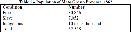
When compared to the data from 1850, one finds that the provincial population grew by 20%, but that the number of slaves diminished by 30% while the number of freemen increased by 50%.9 The data referring to the province’s indigenous population is presented separately and is not divided by county, but shows a certain stability given that in 1849, the number of Indians living in the province was estimated to be between 15 and 20 thousand. At the same time, the Provincial President notes that:
What we can confirm, seeing as how it’s visible and not contestable, is that the Capital, Villa Maria, Villa de Sant’anna do Paranahyba and the settlement of Albuquerque (today more commonly known by the name of Corumbá) are the places in the province which have most grown in population and commerce in recent times… (Relatório da Província de Mato Grosso 1862:36).
In the Paraguay Valley resides almost the entirety of the civilized population of this Province. More than 4/5ths of the occupation around the Capital [is situated in] a space of, at most, 1,600 square leagues along the upper part of the Valley, bordered on the west by the Paraguay River and on the east by the São Lourenço and cut by the Cuyabá; at least 1/10th of the above-mentioned population inhabits the counties of Albuquerque and Miranda, [along] the creeks and the great river, as well as its tributary, the Miranda (Relatório da Província de Mato Grosso 1862:65-66).
What we’d like to call attention to here is the fact that during this period, the villages were expanding. Indian Directors were established to administrate and control said villages and, at the same time, the provincial population was growing in size, especially in the region of the Pantanal10 where the Guaná and Terena were then located.
In this manner the frontier, understood as a region of conflict over the appropriation and definition of spaces and territories, also became an area for experimenting with policies of domination. Policies of alliance and collaboration with indigenous societies were tested by the State’s several apparatuses and, in particular, by the Army as integral parts of a strategy of national defense. During this period, there was little concern about the internal definitions of territorial limits as the Brazilian State’s main problem was conflict with other nation-states. The geopolitical problem of territorial maintenance was more urgent than the question of the economic exploitation of these same territories. The State tolerated certain cultural practices precisely because it needed the Indians as military allies. At the same time, the existence of the border – which had not yet been configured in accordance to the systematic activity of the fronts of expansion – allowed the Indians to occupy a wide swathe of territory at different points in southern Mato Grosso. In this sense, then, there was formed a space of relative tolerance for ethnocultural diversity and a certain level of concession to Native interests.
The defense of this territory by the State obliged the Brazilian government to use the Native populations as an auxiliary force. At the same time, as the region became more populated and the fronts of expansion became better established, the mobility of the Guaicuru and Guaná Indians and the deep "intermixture" which existed between both societies became the object of policies for controlling and disciplining the Native populations. Native mixture and mobility along the border was increasingly only acceptable in the eyes of the State if it were subordinated to the demands of the market and assimilation with the non-indigenous population. The State could no longer accept interethnic mixture between Native groups, nor their autonomous shifting from one place to another. Certain State agents learned that indigenous cultural identities were so strong that it would be very difficult to someday absorb them within the general population.11 Mixture between the different indigenous groups and the spatial mobility that resulted from their different forms of social organization and relations of production became barriers to colonialism.
In this way, the idea that these indigenous groups originated in one place and time, located within the Chaco and outside of Brazil’s national borders – an idea so very present in today’s legal disputations – is in frank contrast to the historical dynamics of Native circulation and territorial occupation. These dynamics took in many different territorial points (in what is today both Paraguayan and Brazilian land) at different historical moments and involved the exchange of the territories themselves between different political and territorial units (especially within the region now known as the Pantanal), which resulted in their being possessed by different nations (including indigenous nations) at different points in time.
The territories and frontiers were distinct and what is today Brazilian territory was either in dispute or under the jurisdiction of Paraguay or one or another Indian nation. What is today understood to be the Pantanal was part of the Chaco. The border, even though it was the object of experimental policies of control, did not see this control consolidate itself over native groups until after the Paraguayan War. However, the villages that were created as part of the policies of settlement, separation and centralization set the stage in many ways for the post-war period, as they pointed towards a new way of incorporating spaces and territories into national society. In this new formulation, land (understood as a factor of production) would be turned into a highly disputed commodity. These policies prepared the way for the expansion fronts and the definitive incorporation of land into Brazil’s agrarian structure.
Economic expansion fronts, the closing of the frontier and regions of exception
The border of southern Mato Grosso, understood as a political border between two states, was only finally settled in 1870 at the close of the Paraguayan War. The border’s instability and its mobility (given that its demarcating lines were not accepted nor recognized as definitive) created a situation in which the spatial mobility of ethnic groups and their ethno-cultural alterity were seen as problematic by the State. It was only after the territorial limits of the national borders had been fixed that the systematic progress of fronts of economic expansion began to create the conditions for the immobilization of the various ethnic groups along the border and their transformation into a mobile workforce, originally subordinated to the State.
The work of these various expansion fronts – and most particularly and agricultural and ranching front – made possible the structuring of space along the border and the incorporation of the lands of southern Mato Grosso do Sul into the nation. This incorporation simultaneously conditioned the structural form of the region’s agriculture and the place of indigenous lands within this. The main question is knowing when the systematic action of the various expansion fronts definitively began and when the frontier finally closed. According to Octavio Velho, one of the principal indicators of the activity of expansion fronts is accelerated demographic growth. Even though this may not be a definitive element of the fronts, it generally tends to indicate their operation (Velho 1972: 12).
The data presented in Table 2, below, shows the demographic evolution of the province and (later) state of Mato Grosso:
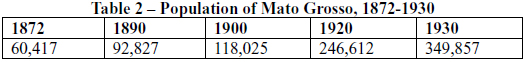
In the 20 years following the Paraguayan War, the total population of Mato Grosso grew by 130%, in comparison with 1850. These numbers do not take in the province’s indigenous population. Within this process of demographic growth, one finds the results of the nation’s policy of encouraging European immigration: from 1872 to 1890, 5,896 Europeans came into the province; from 1890 to 1900, 3,445; from 1900 to 1920, 15,864; and from 1920 to 1940, 47,002. These demographic dynamics accompanied increased socio-economic dynamization. It meant the removal of the province’s manpower problem, which had been cited as the cause of its relative "backwardness" throughout the 19th century.12 "In this way, the end of the war with Paraguay marked the beginning of a phase in which the economy of Mato Grosso was opened up to the world via commerce and navigation along the Paraguay River"13 (Borges 2001:31).
It is also important to remember that a large number of military personnel were stationed in Mato Grosso in this period (especially officers), veterans of the Paraguayan War. These men became farmers and businessmen in the region, as well as part of its nascent rural bourgeoisie.14 We thus have the consolidation of a clear socio-cultural conflict or shock between colonists –foreign or national immigrants coming in from other areas of Brazil – and the autochthonous indigenous peoples of the region. A new phase of colonization was at hand and we can now properly talk of a specific kind of internal colonialism, where new colonists began to occupy the territories of the province of Mato Grosso during the post-war period stretching from 1870 to 1900. This is the beginning of the formation of a capitalist market which would develop under monopoly capitalist conditions, subsidized by the State. Thus, the "economy" gained a strength and autonomy which it did not have in the immediately preceding period.
In general, we can say that two great expansion fronts consolidated themselves during this period. The first was the forest extraction front and the second was the agricultural and ranching front. The forest extraction front saw a boom during the last decades of the 19th century while ranching and agricultural activities developed at a slower – but constant – pace throughout the period. Between 1898 and 1914, production of "erva mate" tea and rubber were responsible for over 80% of the value of the province’s exports, a position which they held even after 1911, when the most dynamic element of the economy became agricultural and ranching activities (Borges, 2001:44-48).
Mate tea production began in 1882, when Tomás Laranjeira gained the rights to exploiting the stretch of land between Júlio and Iguatemi (in the southernmost part of Mato Grosso). This activity would later be consolidated with the formation of the Laranjeira Mate Company, which would come to exercise a monopoly over the sector. Laranjeira Mate became a fundamental component of the power structure within Mato Grosso.15 Rubber, however, would also be an important export of the province. This was extracted in the regions along the Paraguay, Jurena, Arinos and Paranatinga and Alto Tapajós Rivers. After the crisis of 1910, Brazilian rubber production came screeching to a virtual halt. However, within Mato Grosso, forest extraction activities dominated the economy of the first decades of the 20th century.
The greater part of this activity was concentrated in the extreme southern part of the province. Erva-mate and rubber were planted precisely within this region and the development of the ranching and farming economy became fundamental, within this historical framework, for the construction of a new form of power distribution that would completely alter the lives of the Terena Indians.
Ranching and farming were already being practices as an important economic activity in the region since 1850.16 During the post-war period, its importance as an economic sector would grow: "…during the 1878-1879 economic year, it began to gain significant importance, mostly when we observe that the exportation of cattle, dried meat, horn and horse manes brought in moneys… which would correspond to over half of the value of the province’s exports" (Borges, 2001: 76).
In 1915, Mato Grosso had the 4th largest bovine herd in Brazil, with 2,690,454 head of cattle. The principal municipalities concentrating this industry were:
1. Campo Grande
2. Ponta Porã
3. Bela Vista
4. Corumbá
5. Coxim
6. Aquidauana
7. Três Lagoas
8. Miranda
In other words, the Pantanal was at that point already a region which concentrated agriculture and ranching, a tendency which began shortly after the Paraguayan War. Though ranching and agriculture was the third most important activity in the state during the initial years of the First Republic, became a constant source of economic activity and, after the 1920s, took off as the principal economic activity of Mato Grosso. Large companies began to operate within this area, the most important of which was The Miranda Estância Company, which controlled 219,056 hectares in Miranda (Borges, 2001: 79).
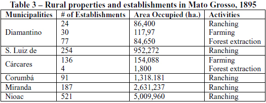
In Table 3, we clearly see that "ranching" (a term used at the time to denote both ranching and its derivative products such as leather, dried meat and horn) is the only activity that appears in all of the municipalities for which we have data. Miranda stands out here as having the second largest concentration of land engaged in this activity. The village of Miranda was precisely where the Terena were located, always keeping in mind that the territory of the municipality of Aquidauana was part of the Village of Miranda in the 19th century.
We can thus clearly see how national society’s expansion fronts operate in the post-war period following 1870. The development of a farming and ranching front in the Pantanal region exponentially increased the demand for lands in that area and the process of delimiting and demarcating these lands was delayed. Even towards the end of the 19th century, there were few establishments with clear land title, with the vast majority operating as squatters.17
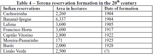
60 years would pass from the beginning of the systematic operation of the expansion fronts and the "closing of the frontier" in the Pantanal region. During this period, the region’s land was incorporated into the national agrarian structure under a new form of regulation of access to and possession of property in land. The old instability so characteristic of the period before the Paraguayan War was substituted by a rigid norm of patterns of access to and permanence upon the land, with the market mechanism of sale and purchase becoming predominant. Some ten years after the process of regularization of land possession began, the process of the demarcation of Terena land and the establishment of reservations was initiated. During the 20th century, State intervention in this process via the SPI (Indian Protection Service), particularly within the southern region of Mato Grosso, established processes of territorialization and directed social change that fixed the Terena on "reservations". Table 4, below, synthesizes this process of reservation construction, engaged in by the SPI:
Many of these demarcations were the result of federal, state, or municipal decrees, and they led to questions on both the Indians and landowners parts. The demarcation thus did not effectively occur in many cases and was often not accepted in those cases in which it did. From the moment in which the ranching and agricultural expansion fronts begin to operate, a restructuring of space occurs which eventually results in the closing of the frontier. In this restructuring, the Terena are settled on certain parcels of land and are transformed into a mobile labor force under the direction of the State. The old pattern of indigenous mobility and ethnic intermixture gave way before the establishment of the reservations, with each ethnic group settled on a small plot of ground. According to SPI policy, this was an adequate measure which would lead to the Indians’ assimilation and incorporation into national society.
João Pacheco de Oliveira Filho has hypothesized that a direct relationship existed between the effectiveness of the demarcation processes of Indian lands and the activities of the Pioneer fronts.18 He points out that indigenous lands were first demarcated in precisely those areas where the expansion fronts were active. We can also add to this hypothesis, in the case of southern Mato Grosso. Here, the effectiveness of demarcation moved hand-in-hand with the rhythm of the closing of the frontier and the need to regionally define property relations and structuring of social-spatial organization. In the south of Mato Grosso, the expansion fronts affected the closing of the frontier and the demarcation of Indian lands was part of a greater structuring of space that consolidated and institutionalized a given configuration of spatial occupation produced by the shock of internal colonialism. In other words, these demarcations expressed the correlation of indigenous and colonial forces during the late 19th and early 20th century. The closing of the frontier necessarily implied the demarcation of all lands, not just indigenous territories, but all lands in the state. Reservation demarcation was thus part of a larger, global move towards the consolidation of the agrarian structure of the border region.
Another important point is that before the closure of the frontier, a certain tolerance existed with regards to indigenous lands. Indians were guaranteed the use of the land, but were never given formal title to it (something which occurred with regards to most lands in the border region in general, even those used by non-Indians). Although legislation already existed in the 19th century which supposedly assured Indians possession of the lands they occupied, these guarantees stood in frank contrast to the social configuration of the frontier, which insured that conflicts of interest would be resolved by material and symbolic force, due to the instability of territorial definitions and the characteristic conflicts of internal colonialism. In short, land tenure was resolved by the manipulation of the juridical structure and by the systematic use of violence. The border region was necessarily a place where exceptions were the rule in the sense that internal colonialism and the land conflicts generated by all colonial situations could never co-exist within a strict interpretation of the law, given that the law itself was not an instrument for the mediation of interests but a vehicle which expressed the contradiction of interests, as well as an artifact of hegemonic power.
The view that Indians have spontaneously occupied only those territories in which they are currently found is thus in frank contrast with the data that shows that the process of the closure of the frontier was what defined the settlement of Indians and gave birth to the idea that they "only occupied the villages". In reality, the historical data shows the opposite: aside from the state-run villages, there were several other nuclei of decentralized indigenous occupation throughout the territory, as well as official villages which are today extinct. In today’s on-going struggle over judicial processes, however, a model of indigenous society is projected on the past (on the moment when the frontier was still open in the 19th century), stipulating as eternal a form of social and territorial organization that only came into being after the closure of the frontier in the early 20th century. This model holds that each ethnic group occupied a separate and tiny parcel of land which was clearly delimited and that these are properly each group’s "indigenous lands". This image, however, only grasps as "true and eternal" the territorial effects of State indigenous policy, produced at the moment in which the frontier was closed.
The closing of the frontier produced the region’s agrarian structure and the Indian’s modern place within it. This place was established through the conjuncture of two factors: the actions of the Indian Protection Service (the SPI) and the specific social conditions of the frontier. Action on the part of the SPI aided the consolidation of the agrarian structure and, at the same time, introduced a kind of policy which acted directly upon Indian identity. In this fashion, the judicial conflicts around the demarcation of indigenous lands are nothing more nor less than an indirect consequence of the manners in which lands were incorporated into the agrarian structure and the types of policies the State directed towards indigenous societies in the early 20th century. The Terena Indians demands for land are, in turn, a means of questioning the ways in which these spaces were incorporated and distributed within the regional agrarian structure during the initial period of the activities of the expansion fronts.
In a certain sense, then, at the moment in which the process of land regularization begins, at the beginning of the closing of the frontier, when these lands are put onto the market, indigenous lands are situated at an inferior level within the hierarchy of spaces within the region. Regularization of Indian lands not only took place after other landowners were given title to their properties (Terena lands only begin to be demarcated in 1906 and, later, after 1920), the demarcation of these lands was seen as a specific part of a greater policy directed towards the forced assimilation of the Indians into national society and their transformation into salaried workers. The consolidation of the closure of the frontier with the structuring and incorporation of spaces within a global system thus combines questions relating to the administration of both identities and territories.
The Pantanal region, as a border region, was the target of Indian affairs policies that sought to nationalize and assimilate Native societies through plans of directed cultural change which also sought to insure greater vigilance along the border. In this fashion, the localization of Native ethnic groups in a region crossed by an international border modified the situation of the Indians of southern Mato Grosso and, in particular, the Terena, transforming them into targets for policies that were simultaneously directed at territories, identities and populations. The problem of indigenous identities thus emerges alongside the question id how to assimilate these identities within the greater Brazilian national identity. The problem of defining the limits of Indian territory is thus replaced by the problem of defining the limits of Indian identity.
Borders and Identities
The consolidation of Brazilian national borders and the delimitation of internal frontiers into public lands, Indian lands and private properties within an agrarian structure was a process that was also accompanied by the creation of legitimate representations regarding each of these spaces within Brazilian society and its social imagination. The delimitation of Indian lands also implied the attribution of a symbolic place for Indians. They were to occupy the lands set aside for them by the State because these were supposedly the lands they had occupied from time immemorial. Such spaces were also the place where Indians had their duties, given that they were to occupy them only until they had become appropriately assimilated into national society by the SPI. As Lima and Oliveira Filho have both noted, the reservations, agricultural centers and other like artifacts expressed in administrative terms the transitory condition that was supposedly "Indianess" (Lima, 1995; Oliveira Filho, 1999). A cyclical argument was thus set up: Indians exist in determined spaces because they’ve always existed in these spaces because that is where they should exist.
The SPI’s policies were, above all else, policies geared towards the nationalization of the Indians. The policies for the Terena villages and reservations in southern Mato Grosso sought to consolidate these spaces as a channel for the assimilation of the Terena and their transfiguration from an ethnically distinct people into an integral part of a homogenous national identity. The border was thus also a zone in which the boundaries of social identities were to be the objects of conflict and the targets of disciplinary policies. These policies were in place throughout the SPI’s existence and were in evidence even after that agency became FUNAI (the National Foundation of the Indian). They were based upon and expressed the notion that the Terena were acculturated Indians well along the road to complete assimilation. This view of the Terena, established by the Indian affairs bureaucracy, then went on influence other social actors and institutions:
Nationalization discourse continues to revolve around the notion of indigenous groups situated at various points along the scale of human evolution, given that Decree #5484, of 27/07/1928, which categorizes the relative degree of "contact" [between Indians and non-Indians] and which is still the touchstone of indigenist activity, has continued in place… For example, of the two kinds of SPI posts which were discussed at the time, "Attraction, Vigilance and Pacification Posts" were to deal with those peoples who were "peaceful unarmed and in their social infancy, in order to awaken in them the desire to achieve the level of progress that we ourselves have reached"… The second kind of post, the Assistance, Nationalization and Education Post, was set up by the regulations to serve one or more already pacified and settled tribes, capable of being adapted to ranching or farming activities, as well as other normal occupations (Lima, 1992: 166).
Nationalization was thus conceived as a pedagogic process involving education and work or, better yet, (technical) education for work. In the 1940s, the SPI’s organizational chart was restructured in order to better deal with these two duties, with the agency being encouraged to once again promote the concept of the Indian as the guardian of Brazil’s borders, and Indigenous Posts and Inspectorates were organized along these general lines. This structure would only begin to be changed in the 1960s19. In Table 5, we can see how Indigenous Posts were distributed around the south of Mato Grosso:
The data presented above allows us to see that the tasks allocated to Indian affairs in southern Mato Grosso were different to those allocated to the indigenous bureaucracy in the north of the State. In IR-6 (in the north of Mato Grosso), six of the eleven indigenous posts were "attraction posts" (none of these existed in the south) while the remaining five were nationalization posts, most of these serving the Terena. This means that, in this period, the tutelary and political regime of Brazilian Indian affairs was being used to promote policies of nationalization: the construction and imposition of a Brazilian national identity upon the native peoples. This resulted in an impulse to preserve and guarantee a "slow process of acculturation" while simultaneously accelerating the process of incorporating the Indian into the nation as rural laborers. As anthropologist Altenfelder Silva pointed out in the case of the SPI’s activities among the Terena of the Bananal20:
By the initiative of the Indian Protection Service, the "feast of the priests", the Oheokoti, was re-established and is now celebrated on the 19th of June, Indian Day, together with other Brasilio-Indigenous civic ceremonies. These include the raising of the Brazilian Pavilion to the sound of the National Anthem, played by the Indians, and the realization of Terena dances, which have now been revived (Altenfelder Silva, 1949: 359).
But the policies of assimilation that were applied to the Indians of the border region had very diverse effects at the local level. In the case of Terena society, nationalistic political elements were incorporated into the group’s ritual and mythic universe. The experiences of the Indians along the border and the political questions produced by these experiences were transcribed into indigenous narratives in such a way that certain historical events gained mythical contours in the indigenous interpretation of indigenous history and the history of colonization.
The fundamental element is that the Terena today present (in ritual and mythic form) narratives that do not oppose native identity and national identity, but rather juxtapose or superimpose the two. Terena narratives, for example, point to the indigenous character Kaly Syny, who appears in the narratives of the Indians of Cachoeirinha and Limão Verde (even being mentioned in pamphlets produced by the Indians) as a chief and a koixomuneti (shaman) who supposedly brought the Terena up the Paraguay River and was a principal native figure during the War. Kaly Syny is said to have actively organized the Terena during the War with Paraguay and to have come to the aid of the Brazilian troops, helping them with his shaman’s powers to defeat the Paraguayans in several battles.
One ritual which expresses this narrative is the hiokixoti-kipahe (dance of the ema bird, or – as it’s more commonly known – the "stick beating dance"). This dances is ritually practiced on all important occasions by the Terena, including Indian Day and the Saints Festivals undertaken in almost all indigenous communities. Indian Day is particularly emblematic, given that it operates a certain ritualistic duality, enacting nationalistic rituals (as Altenfelder Silva pointed out) such as the raising of the flag and the singing of the national anthem, and also indigenous rituals such as the stick-beating dance. The questions that are raised by the interwoven rituals are extremely complex, given that they demonstrate an appropriation of national symbols (such as the Brazilian flag) within indigenous ritual. The flag is held by the Terena or even physically connected to their clothes of bacuri palm fiber and ema feathers in such a way that it becomes literally impossible to separate Terena and national identity.
There are also other interpretations regarding the meaning and origin of the stick-beating dance. In general, the Terena agree that the dance was revealed to a shaman in his dreams and that this shaman then taught it to the other Indians. However, two distinct versions of this myth are narrated, although both are linked to the War and the group’s socio-historical experience. One version of the story indicates that the dance portrays a war between two indigenous nations in the Chaco or Exiwa, and that it is undertaken to memorialize the dead. Another version affirms that the dance was revealed to the shaman after the Paraguayan War to remember the Indians that took part in it in order to defend their lands and to remember the Indian blood that was shed in this cause. The dance is a ritual undertaken to remember struggles and the Indians which fought and died in them. The identity of the Terena Indians, expressed in this ritual form, links both ethnicity and nationality. Different from what the SPI and FUNAI’s nationalization policies sought to create with regards to cultural homogenization and assimilation, national symbols were reworked according to local Indian interpretations in the dance, inverting the logical opposition between ethnicity and nationality and creating a plural identity. At the same time, the narratives that are linked to the ritual express an indigenous point of view regarding their historical experience along the border, emphasizing the element of conflict and war which characterized this experience and creating a counter-discourse that emphasizes the Terena’s importance to national history due to the role the group played in the Paraguayan War. This counter narrative, in turn, legitimizes the Terena’s land claims, given that the group can point to their defense of Brazilian territory as proof of their "Brazilianess".
In this way, the hypothesis that ethnic identity is necessarily exclusive of national identity, where "ethnic" is understood to mean a supposedly "external" origin which must be either be assimilated or understood as primordial, stands in frank contrast to an observable sociocultural reality in which the Terena’s specific ethnic identity is inextricably linked to Brazilian national identity. This linkage is in part due to the peculiar historical conditions of the border region and in part due to the group’s strategies and processes of appropriation. The Indians can thus be understood as having produced their own discourse, through myth and ritual, which speaks of the group’s origins and which links historical and magical-religious elements, justifying not only the Terena’s presence in the territories which they currently occupy, but also the legitimacy of their demands for land. Ethnic identity and its boundaries are thus not closed to the effects of historical processes and the policies applied to the economic and political frontier regions. In reality, Terena ethnic identity transformed itself throughout its history, linking itself to national identity in such a way that national and ethnic identity have become interposed – even though the Indians never became assimilated in the sense of being folded into the greater population, losing their ethnic identity. This fact makes the struggle for classification in today’s judicial processes regarding the Terena that much more complex.
This struggle highlights yet another conflict over the power to create legitimate representations regarding social identities and the maintenance or transformation of certain aspects of the agrarian structure. In the case of the Pantanal region in Mato Grosso do Sul and the Terena Indians which occupy this region, we can clearly see that the border affected the group’s process of territorialization and the definition of its current identity. The experience of occupying territories along the border determined the Terena’s spatial location and the form and content of their ethnic identity. It’s not just the territorial limits of the border that are mobile, but also the boundaries of the social identities of the groups which are located along it, given that this location implies their subjection to different types of policies, both symbolic and economic, which condition the development of social groups and territories and which give them their specificity.
Ethnic and national identities – like borders, frontiers and boundaries – are re-elaborated according to power relationships. They are essentially mobile, in time as well as in space, and this fact makes the questions brought up by the struggles to demarcate and identify Indian land even more complex. The judicial processes and the political-juridical strategies adopted in the fight against the demarcation of indigenous lands impose certain representations as legitimate. However, when we analyze history and the evolution of the border, we see that a century ago, neither territories nor social groups were encapsulated within the limits in which they are found today and that, furthermore, their identities have not remained static over time but have progressively been shifted, cut, regrouped, and reformulated by political struggles, wars, colonization and the workings of expansion fronts. We then see that the representations contained in the discourses of the actors who are today in conflict with one another should be understood as a part of a greater struggle over classifications and not as a key to understanding reality as it is classified and represented by these actors.
Bibliography
ANDERSON, Benedict. 1989. Nação e consciência nacional. Rio de Janeiro: Editora Ática.
AZANHA, Gilberto. 2001. Relatório de identificação das terras indígenas Cachoeirinha, Buriti e Taunay-Ipegue. Centro de Trabalho Indigenista. http://www.trabalhoindigenista.org.br
BACH, J. 1916. "Dados sobre los Índios Terenas de Miranda". Anales de la Sociedad Científica Argentina. Buenos Aires. pp.. 87-94.
BAINES, Stephen G. 1993. "A política indigenista governamental e os Waimiri-
Atroari: administrações indigenistas, mineração de estanho e a construção
da autodeterminação indígena dirigida". Revista de Antropologia, 36:207-237.
BALANDIER, Georges. 1993. "A noção de situação colonial". Cadernos de
Campo, 3:107-131.
___. 1969. Antropologia política. Barcelona: Ediciones Península.
BARTH, Fredrik. 1996. "Economic spheres in Darfur". In: F. Raymond (org), Themes in economic anthropology. Londres: Tavistock. pp. 149-174.
___. 2000a. "Os grupos étnicos e suas fronteiras". In: Tomke Lask (org.), O guru, o iniciador e outras variações antropológicas. Rio de Janeiro: Contra Capa. pp. 25-67.
___. 2000b. "A análise da cultura nas sociedades complexas". In: Tomke Lask (org.), O guru, o iniciador e outras variações antropológicas. Rio de Janeiro: Contra Capa. pp.107-140.
___. 2000c. "Por um maior naturalismo na conceitualização das sociedades". In: Tomke Lask (org.), O guru, o iniciador e outras variações antropológicas. Rio de Janeiro: Contra Capa. pp. 167-186.
BATALHA, Guillermo Bonfil. 1972. "El concepto de índio en América: una categoria de la situacíon colonial". Anales de Antropologia, IX:105-124.
___. 1979. Indianidad y descolonización en América Latina. México: Editorial Nueva Imagen.
BECKER, Berta. 1990. "A fronteira em fins do século XX: oito proposições para um debate sobre a Amazônia". In: ___. et al. Fronteira Amazônica: questões sobre a gestão do território. Brasília/ Rio de Janeiro: Editora UnB e Editora UFRJ. pp. 15-25.
BORGES, Fernando Tadeu de Miranda. 2001. Do extrativismo à pecuária: algumas observações sobre a história econômica de Mato Grosso. 1870 a 1930. São Paulo: Scortecci Editora.
BOURDIEU, Pierre. 1990. Coisas ditas. São Paulo: Editora Brasiliense.
___. 1989. O poder simbólico. Rio de Janeiro: DIFEL.
CAMPESTRINI, Hildebrando & Guimar ães , Acir Vaz. 2002. História de Mato Grosso do Sul. Mato Grosso do Sul: IHGB.
CARDOSO DE OLIVEIRA, Roberto. 1976. Do Índio ao Bugre: o processo de assimilação dos Terena. Rio de Janeiro: Editora Francisco Alves.
___. 2002. O diário e suas margens: viagem aos territórios Terena e Tukuna. Brasília: Editora UnB.
___. 1968. Urbanização e tribalismo: integração dos índios Terena numa sociedade de classes. Rio de Janeiro: Zahar Editores.
CARVALHO, Edgard de Assis & JUNQUEIRA, Carmen. 1981. Antropologia e indigenismo na América Latina. São Paulo: Cortez.
CARVALHO, Silvia M. S. 2002. "Chaco: encruzilhada de povos e ‘melting pot’ cultural, suas relações com a bacia do Paraná e o sul mato-grossense". In: Manuela Carneiro da Cunha (org.), História dos índios no Brasil. São Paulo: Companhia das Letras. pp. 457-474.
CASANOVA, Pablo González. 2002. Exploração, colonialismo e luta pela democracia na América Latina. Petrópolis: Vozes.
___. 2007. "Colonialismo interno (uma redefinição)". In: A. A. Boron; J. Amadeo & S. Gonzalez (orgs), A teoria marxista hoje. Problemas e perspectivas. http://bibliotecavirtual.clacso.org.ar/ar/libros/campus/marxispt/cap.19.doc
CASTELNAU, Francis. 2002. Expedição às Regiões Centrais da América do Sul. Belo Horizonte: Editora Itatiaia.
CENSO da População dos Índios Desaldeados em Campo Grande/MS 1999. 2000. Campo Grande: UCDB, CIMI, PMCG e Arquidiocese de Campo Grande-Pastoral do Índio. 84p.
CLIFFORD, James. 1994. "Diásporas". Cultural Anthropology, 9(3):302-338.
COSTA, Maria de Fátima. 1999. História de um país inexistente: o Pantanal entre os séculos XVI e XVIII. São Paulo: Editora Estação Liberdade e Livraria Kosmos Editora.
CUNHA, Manuela Carneiro da. 1987. Os direitos do índio: ensaios e documentos. São Paulo: Editora Brasiliense.
___. (org.). 1992. História dos índios no Brasil. São Paulo: Companhia das Letras.
FERREIRA, Andrey Cordeiro. 2002. Mudança cultural e afirmação identitária: a antropologia, os Terena e o debate sobre aculturação. Dissertação de Mestrado, Universidade Federal do Rio de Janeiro, MN-PPGAS. xii, 117p. il.
FOUCAULT, Michel. 1997. A arqueologia do saber. Rio de Janeiro: Editora Forense Universitária.
___. 1999. Em defesa da sociedade. São Paulo: Martins Fontes.
FREIRE, Carlos Augusto da Rocha. 1990. Indigenismo e antropologia: o Conselho Nacional de Proteção aos Índios na Gestão Rondon (1939-1955). Dissertação de Mestrado, Programa de Pós-Graduação em Antropologia Social, Museu Nacional/UFRJ. 379p.
KUPER, Adam. 1992. Conceptualizing Society. London: Routledge.
___. 1999. Culture: The Anthropologist’s Account. Cambridge/Massachusetts/London, England: Harvard University Press.
LENA, Philippe & Oliveira, Adélia Engrácia de. 1991. Amazônia: a fronteira agrícola vinte anos depois. Belém: Museu Paraense Emilio Goeldi.
LIMA, Antonio Carlos de Souza. 1995. Um grande cerco de paz: poder tutelar, indianidade e formação do Estado no Brasil. Petrópolis/RJ: Editora Vozes.
___. 1998. "Os relatórios antropológicos de identificação de terras indígenas da Fundação Nacional do Índio. Notas sobre o estudo da relação entre indigenismo e antropologia no Brasil, 1968- 1985". In: João Pacheco de Oliveira Filho (org.), Indigenismo e territorialização: poderes, rotinas e saberes coloniais no Brasil contemporâneo. Rio de Janeiro: Contra Capa. pp. 221-268.
___. 1992. "O governo dos índios sob a gestão do SPI". In: Manuela Carneiro da Cunha (org.), História dos índios no Brasil. São Paulo: Companhia das Letras. pp. 155-172.
METRAUX, Alfred. 1946. "Ethnography of The Chaco". In: J. Steward (org.), Handbook of South American Indians, volume 1. Washington: United States Government Printing Office. pp. 197-370.
MOREIRA NETO, Carlos de Araújo. 1971. A política indigenista brasileira durante o século XIX. São Paulo: Faculdade de Filosofia, Ciências e Letras de Rio Claro.
OBERG, Kalervo. 1948. The Terena and the Caduveo of southern Mato Grosso, Brazil. Washington D.C: Department of State, US Government Printing Office/ Smithsonian Institution Institution/ Institute of Social Anthropolgy, Publication Nº. 9. 74 p.
OLIVEIRA FILHO, João Pacheco de. 1999. Ensaios em antropologia histórica. Rio de Janeiro: Editora da UFRJ.
___. 1986. "Antropologia política". In: Dicionário brasileiro de ciências sociais. 1.ed. Rio de Janeiro: FGV/MEC. pp. 64-67.
___. (org.). 2006. Hacia una antropologia del indigenismo. Rio de Janeiro: Contra Capa.
___. (org.). 1998. Indigenismo e territorialização: poderes, rotinas e saberes coloniais no Brasil contemporâneo. Rio de Janeiro: Contra Capa.
___. 1988. O nosso governo: os Ticuna e o regime tutelar. Rio de Janeiro: Editora Marco Zero.
SILVA, Fernando Altenfelder. 1949. "Mudança cultural dos Terena". Revista do Museu Paulista, III:271-379.
SUSNIK, Branislava. 1978. Los aborígenes del Paraguay: etnología del Chaco
Boreal y su periferia (siglos XVI e XVII). Assuncion: Museo Etnográfico Andrés Barbero.
___. 1981. Los aborígenes del Paraguay: etnohistoria de los chaqueños (1650-1910). Assuncion: Museo Etnográfico Andrés Barbero.
VARGAS, Vera Lúcia Ferreira. 2003. A construção do território terena (1870-1966): uma sociedade entre a imposição e a opção. Dissertação de Mestrado em História. UFMS, Dourados. Ms. 161p.
VASCONCELOS, Cláudio Alves de. 1999. A questão indígena na província de Mato Grosso: conflito, trama e continuidade. Campo Grande: Editora UFMS.
VELHO, Otávio Guilherme. 1979. Capitalismo autoritário e campesinato. Rio de Janeiro: DIFEL.
___. 1972. Frentes de expansão e estrutura agrária. Rio de Janeiro: Zahar Editores.
Reports of the Provincial Presidents
(at the Center for Research Libraries: /www.crl.edu/content)
Relatório de 1837. José Antonio Pimenta Bueno, 01/03/1838
Relatório de 1838. José Antonio Pimenta Bueno, 01/03/1838
Relatório de 1840. Estevão Ribeiro de Rezende
Relatório de 1849, 3 de Maio. Pelo Major Doutor João de Oliveira.
Relatório de 1851, 10 de Maio de 1851. Pelo Capitão de Fragata Augusto Leverger
Relatório de 1857. Albano de Souza Osório.
Relatório de 1858. Albano de Souza Osório.
Relatório de 1859. Joaquim Raimundo de Lamare
Relatório de 1862. Herculano Ferreira Penna
Relatório de 1863. Herculano Ferreira Penna
Relatório de 1864. Alexandre Manoel Albino de Carvalho
Relatório de 1865, 17 de outubro. Augusto Leverger
Relatório de 1869. 20 de Setembro. Barão de Melgaço.
Relatório de 1872. Cardozo Junior
Relatório de 1877. 03/05/1877. General Hermes Ernesto da Fonseca
Relatório de 1879. 05/12. João José Pedrosa.
Relatório de 1893.
Relatório de 1895.
* The present paper is a re-reading of data contained in my doctoral thesis, Tutela e Resistência Indígena (Museu Nacional, 2007), representing my reflections upon my activities as a judicial expert in a land dispute involving the Indians of Limão Verde in Mato Grosso do Sul.
** Andrey Cordeiro Ferreira has a PhD in Social anthropology from PPGAS/MN/UFRJ and is a professor social sciences at Federal Rural University of the Rio de Janeiro. E-mail: <andrey2099@hotmail.com>.
*** Translators’ note: in Portuguese, the words "border", "frontier" and (oft-times) "boundary" are all expressed by the term "fronteira". The reader should thus be aware that all these terms, as used in this article in English, represent the same word in Portuguese which, as the author notes, is quite polysemic.
1 A group of Cachoeirinha Indians occupied the Fazenda Santa Vitória, which is inside the territories identified by FUNAI's working group.
2 Another part of the political-juridical strategy seeks support in Súmula 650 of the STF which deals with extinct villages. Thus it is simultaneously affirmed that occupation of these lands has not been from time immemorial and that, if it occurred, it was voluntarily interrupted, leading to the extinction of the villages.
3 The concept of internal colonialism is linked in its origins to the phenomena of the Conquest, in which native populations are not exterminated but are, first of all, surrounded by the colonizing State and later by an independent Nation State, once formal independence has been achieved from the motherland. The peoples, minorities, or nations which are colonized by this Nation State suffer conditions similar to those groups which are the victims of international colonialism (Casanova, 2007).
4 "Chaco" (Chacu in Quechua) initially indicated the Province of Tucumán and later designated all the territory to the east of this province, some 700 square kilometers taking in lands under the control of Argentina, Bolivia, Paraguay and Brazil (Carvalho, 2002: 457).
5 "The Terena sought advantage in Xerez Province on the other side of the Rio Paraguay, especially after the reductions were founded among the Itatim-Guarany of Caaguasú and Tare. Their relationship with the Guarany in the reductions (and apparently also with the free Itatins) was based upon periodical exchanges. This was the only way in which the Terena could acquire iron in exchange for cottoon Chanés mantles." (Susnik, 1978: 113).
6 "The Cuaicurus and the Guanás are two great nations that had taken control of the banks of the Mondego prior to the arrival of the Portuguese, warring with the Guaxis, the earlier inhabitants" (Castelnau 2000:403). The "Mondego" referred to here is the Miranda river, as Castelnau explains in his book.
7 A map in the Brazilian National Archives, originating with the Serviço do Estado Maior do Excercito (the Army General Staff Service), presents the Spanish settlements and villages in southern Mato Grosso.
8 According to report: "In the Lower Paraguay district, several tribes, of the Guaná and Guaicurú nations in particular, have several villages where one can see the beginnings of civilization and which maintain more or less constant relations with us (Capitão de Fragata (Commander) Augusto Leverger, Relatório 1851, pp. 44-45). The catechism and civilization of the Quiniquinau had thus been begun in 1831.
9 Mato Grosso had a policy of encouraging European immigration as a means of colonizing the region, resolving its labor problems and guaranteeing its economic development (see Relatório da Província de Mato Grosso 1862, pp.39-40).
10 The report mentions the concession of 266 lots in Corumbá for the construction of houses. Population:1,187 Brazilians (316 officials and soldiers); 84 foreigners (French, Spanish, Italian, German, Argentine, Corrientinos [from the Argentinean province of Corrientes] "Orientals", Bolivians, Americans); 44 slaves.
11 Caetano Pinto de Miranda and Ricardo de Almeida Serra refer to themselves using these terms in some of their reports.
12 These sorts of arguments can be found in almost all of the reports of the Provincial President.
13 The Brazilian Imperial Government took some measures to encourage commerce in the region: 1) The reopening of a customs house in Corumbá; 2) The lifting of taxes on merchandise which circulated in the port. The basis was thus established for an economic renaissance based upon free commerce.
14 The city of Aquidauana, for example, was founded by a group of Coronels who were extremely influential in local politics.
15 "In the message presented to Legislative Assembly on the 13th of May, 1924, the President of Mato-grosso, Pedro Celestino Correâ da Costa, said that while the State's revenues were five thousand contos, the mate company, by itself, took in thirty thousand contos and the State even borrowed money from the company" (Borges, 2001; 59).
16 "Only one branch of wealth of any importance has grown: that of cattle raising, partly in this Municipality and partly in Poconé. As our exportation has been reduced to almost no gold, few diamonds, small quantities of leather and richardia brasilensis and some cattle to the Provinces of Minas and S. Paulo, commerce has been almost exclusively fed by the large sums which are annually released by the National Treasury..." (Relatório de Presidente da Província 1851:14).
17 The report also indicates that the following numbers of claims were in the process of being regularized: before 1854, 1,333 establishments; before 1889, 1,393 establishments; no date, 297 establi9shmennts. Of these, only 452 had been duly marked and demarcated. "Of these 3,209 registered claims, only 1941 have declared the area as occupied, with a total surface of 13,753,011 hectares. If we were to arbitrate the remaining 1,802 claims, almost all dating to before 1854 and with an average of 13,068 hectares each, the total of this surface would be an additional 14,139,576 hectares" (:20. The total area covered by the claims is 27,892,587 hectares out off a total of 218,562,300 hectares for the state of Minas Gerais.
18 "For now, it is enough to hypothesize a correlation between the advance of the pioneer frontiers (and the consequent incorporation of this region into the market economy) and the effectiveness demonstrated in the process of demarcating indigenous lands" (Oliveira Filho 1998:29).
19 According to an agreement to reorganize the SPI (see Lima, 1995).
20 It is interesting to see that, even though these rituals have been systematically reported since the 1920s, here the talk is of "reviving" them.
