My SciELO
Revista de Humanidades y Ciencias Sociales (Santa Cruz de la Sierra)
Print version ISSN 1819-0545
Rev. humanid. cienc. soc. (St. Cruz Sierra) vol.3 no.se Santa Cruz de La Sierra 2007
Three pre-concepts regarding the internal migration in Bolivia*
Hubert Mazurek
Translated by Jeremy Jordan
Translation from Revista de Humanidades y Ciencias Sociales (Santa Cruz de la Sierra), Santa Cruz de la Sierra, v.14, n.1-2, p.1-18, June/Dec. 2008.
SUMMARY
Migration in Bolivia is a historical and widespread phenomenon which has profoundly modified the dynamic and structure of the territory in the last 30 years. However, in this topic there are various pre-concepts linked to the political and cultural polarization that exists in this country. These three pre-concepts: the massive migration from the west towards the east; the change in distribution of the population; and the migration of the poor, are analyzed in this article in order to show that the situation is more complex and that they can cause dramatic consequences that affect the population's culture of some regions, as well as the economical growth of the country.
Introduction
Mobility and migration are fundamental and ancient features of the population's dynamic in Bolivia. They have their roots in the pre-Hispanic period, due to the necessity of productive diversification and exchanges. The famous "vertical control of the ecological grounds" for productive diversification, and furthermore, the increase of contacts of the Andean population with the coast and the jungle shows a society based on mobility (Dillehay, 1979; Murra, 1975).
In spite of colonial pressure to "reduce" the population to ranches or communities, one can always observe the extraordinary mobility of the Andean people and the practice of double or triple residence, at the locations of living, production or exchange (Saignes, 1987).
Since the agrarian reform, and particularly since the mining crisis, in the 80's, mobility and migration have taken different forms:
• There has been stressed the importance of international migration by two different ways: definitive migration towards European countries or the United States; opportunistic or seasonal migration towards neighboring countries, mainly Argentina or Chile. Several writers talk about a new form of range of migratory territory to a transnational level, which becomes substantial with the increase of ways of activity associated with individual or familiar mobility, crossing the borders (Vargas, 1997; Hinojosa, 2004; Mazurek, 2007).
• An internal migration has been developed as a result of the "rotation" of the exploitation of natural resources (Deler, 1991; Mazurek & Arreghini, 2006). Migration towards urban locations has increased, as well as the colonization of new lands around the regions of Chapare, Yungas and the zone of expansion of soya. Nowadays, the impulse of hydrocarbon production gives place to new regions of attraction such as el Chaco, Tarija or Puerto Suárez due to the exploitation of Mutún.
• The internal mobility is associated with the diversification of the work force or with the productive diversification, which we will call a "new horizontal control of production". This mobility can be of short or long term, near or far, or frequently it can cross the borders. It is a strategy of opportunity in the life cycle of the family, which generally stresses territories defined by mobility and by a conscious organization (Vargas, 1997). These territories are constituted and consolidated in the case of trans-border mobility (Hinojosa, et al., 2000; Perrier Bruslé, 2005).
There are very few investigations about these three aspects; neither is there a base of reliable information in order to contemplate the magnitude of the phenomena. This leaves room for speculation about the quantity of people moving, where they are going to and why they are motivated. In the case of international migration, the statements and prospective are quite alarming in spite of it being a phenomena of less importance compared to internal migration (Mazurek, 2007). Internal migration, on one side, does not motivate investigation in spite of being phenomena of great amplitude which has profoundly modified, in 20 years, the structure and territorial dynamic of Bolivia.
The lack of thought put into this topic, a certain idea of the crisis through which the highlands are going through (municipalities of emigration), and the discovery of a certain dynamic of the lowlands (attractive municipalities) generates quite a simple discourse that consists in saying that there is a massive flow of people from the west towards the east1. Some policies (such as ENDAR2) were based on this statement to promote "more dynamic" intermediate cities, in other words, the ones that grow or attract the most. It is true that the pattern of territorial occupation has been profoundly modified during the last 20 years, mainly after the mining crisis that Bolivia had gone through and it can be said that emigration from the highlands is an obvious phenomenon.
However, there are three pre-concepts very deeply-rooted in Bolivian thought, which come from a lack of precise interpretation of national statistical data (to not say a bad interpretation) and at the same time from a discourse among the elite who think to justify and favor, in this way, the lowland's "dynamism" .
These ideas are (1) that there is a massive flow of migration from west towards east, from highlands towards the lower ones; (2) that the consequence of this process is a change in the distribution pattern of the population, in which Santa Cruz Region would be the most populated; (3) that this migration is mainly due to poverty problems.
I propose to retake these three topics, through the same official statistical data (Census of population and housing from 2001), and show that the reality is a little different, and therefore we can end up with very different conclusions. In the actual context of the revision of the constitution, of renovating the topic of territory and identity, this precision seems to be indispensable in order to re-think about Bolivian geographical locations and the complexity of its functioning.
Pre-concept 1: the flows go from west towards east
The reference map in the majority of publications (news media as a scientific publication, CODEPO, 2004, p. 125) is based on the annual net rate of migration (see map 1). This map perfectly shows the rupture existing between east (or lowlands) where the net rate is positive, and west, particularly the high plateau region, where the net rate is negative; even though it is necessary to clarify the distribution contained in a series of significant exceptions: neighboring regions and the urban periphery that still keep attracting, a great part of Chaco, Chapare and Beni started to lose their population.
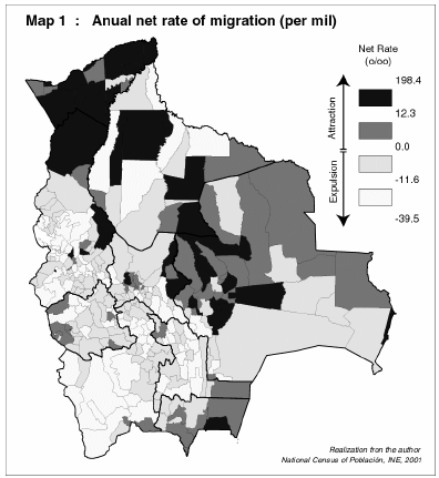
The conclusion about which most of the writers come to is that: "the estimated net rate of migration has allowed us to identify Pando, Santa Cruz, Tarija and Cochabamba, in this established order, as the regions of attraction, insomuch as Potosí, Oruro, Beni, Chuquisaca and La Paz as the ones of losing more population" (CODEPO, 2004, p. 141). That is true in the statistical sense but, does this mean that "there is a movement of the population from west towards east"?
In this first close up view, we will say that there are municipalities that are losing population and others that are gaining them by means of migration, but it is not said when, how or where these flows are directed to.
The previous analysis, which is situated at a "stock" level, in other words, the absolute quantity of people who migrate, can not be interpreted without a complementary analysis of "flows" which would indicate the origin and destination of the migrating population.
The first element of flow analysis, in this article's context, is to know where the highland's migrants go to. Map 2 shows the amount of immigration from, and to other, municipalities located in the highlands (municipality in gray color); it also shows the participation of the highland's immigrants to the total immigration of the municipality.
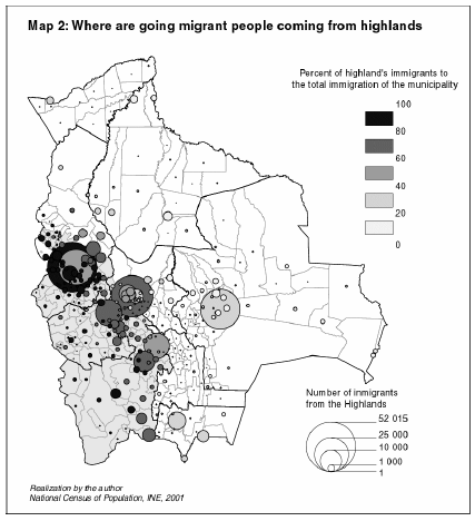
The majority of those who migrate from the highlands go to in the highlands and mainly in the cities. The first destination is south of the region of La Paz and the city of El Alto where more than 80% of the immigrants come from the highlands. Some of the border sites can also be located (Villazón, Tarija, Bermejo or Yacuiba) and the Yungas. The case of Cochabamba and its periphery is also significant when talking about destinations of migration.
The city of Santa Cruz has less immigrants coming from the highlands, than the city of Cochabamba and that doesn't represent more than 28% of the total immigration. The rest of the lowlands receive a low amount of people from the highlands with a proportion almost always less than 30%.
The lowlands (including the Valley region and the cities of Cochabamba and Sucre) received 149,120 people for a total immigration of 503,141 people (29.6%), meanwhile the highlands received 165,256 people out of a total of 229,269 immigrants (72%).
Therefore, we can propose a second question: from where do the people migrating to the lowlands come from? Map 3 answers this question. It is about the origin of the population that migrates towards the region of Santa Cruz.
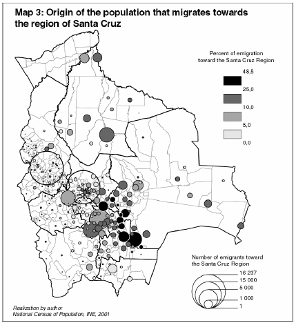
This region attracts very few from the highlands, but from three different origins:
• The cities: La Paz, Cochabamba, the peripheries of these cities (except for El Alto), and in a greater proportion the intermediate cities and the capitals of the regions (except for Cobija).
• Inside one of the nearby zones of attraction: south of Cochabamba, Chuquisaca, Vallegrande area, Chaco (in these two last cases it is about a migration towards another municipality of the region)
• Municipalities in Beni.
The pre-concept of a massive migration from west towards east does not seem to be verified; migration of nearness or cultural migration, in the sense of a migration in the same cultural zone, seems to be the most adequate rule. The most important migration remains in the nearby cities which allow them to keep a cultural and economic link with their place of origin. It is an important feature of internal migration which has been maintained for several decades.
At this stage of reasoning, it is important to analyze if this cultural component (which will be taken up again at the end of this publication) is a common feature to all migration in Bolivia, particularly of migration towards cities which represents the greatest proportion.
For this purpose, we have analyzed the origin of migration from municipalities towards the 4 main cities in Bolivia: El Alto, La Paz, Cochabamba and Santa Cruz, as shown in map 4. These maps show a result of the population who have moved from their place of residence3 in the last 5 years. The circles show the amount of the population, an absolute result, who has migrated towards or from the corresponding city. The municipalities in a lighter gray color have a negative result of migration, while the ones in a darker gray color have a positive result.
We are able to observe four behaviors of migration towards cities which correspond to very different cultural models:
• La Paz is a city with a negative result, mainly due to employment issues and the impossibility of a geographical growth in the urban zone. There is a small zone of attraction remaining, to the north of Lake Titicaca (the Quechua part) but La Paz continues to lose its population. The emigrant's destination is mainly the big cities of the country, and particularly El Alto due to the phenomenon of its proximity, and Santa Cruz due to the economic attraction for professionals. 51% of emigrants from La Paz go to three cities: El Alto, Santa Cruz and Cochabamba.
• El Alto, a neighboring city, shows an opposite behavior. This city loses a very small population (18% of the total of migrants) and attracts very few from outside of its zone of immediate influence: south of the city of La Paz, and particularly the surroundings of Lake Titicaca. The attraction or emigration towards other regions is represented by no more than 28% of the total of emigrants. Migration towards El Alto corresponds to a case of conformity of a very structured cultural and economic basin, where we know that mobility is often more important than definitive migration. A great proportion of the population still has double residency, in their community of origin (maintaining agricultural activity) as well as in the city (opportunity of new ways of activity).
• Cochabamba has always been a city of transition and map 3 confirms this behavior. The city attracts the population from neighboring municipalities (peripheries of the cities, south of the region, west of Oruro and north Potosí), mainly from the highlands and the Valley zone, and loses population towards the lowlands. The migratory result for Cochabamba is almost invalid (-9,060 people which is 8% of the volume of migration); losing 28,396 (27% of the total of migrants) towards the lowlands and the Valley, gaining 20,171 people (19%) from the highlands. It has a double behavior, as mediator between El Alto and Santa Cruz, where there exists the conformity of a basin of migration of proximity associated with a city to city emigration.
• Santa Cruz also has this basin of migration, but losing population towards it and not attracting from it. The result of migration is important (54,207 people which is 30% of the total of migrants) and the immigration comes mainly from the capital cities of this region. Immigration from rural areas is very limited; on the contrary, Santa Cruz has a tendency of losing population towards its own rural zone. 50% of immigration comes from seven cities: La Paz, Cochabamba, Sucre, Trinidad, Oruro, Camiri, Montero; practically all the negative result corresponds to an emigration towards other municipalities of the region of Santa Cruz (Cotoca, La Guardia, San Ramón, San Carlos, Warnes, etc.) and in the city of El Alto (result of -758 people or 23% of migrants between Santa Cruz and El Alto).
In conclusion to this first part, it could be said that there is no real surprise: migration does not follow a flow model from west towards east, but instead it responds to three well known components in the study of migration: migration of proximity, most important flows from and towards cities (principle of gravity) and attraction based on culture with conformation of basins of migration which can have more or less cultural or economic importance.
Long distance rural migration is of less importance; on the contrary migration tends to reinforce urban poles of proximity. However there is a long distance urban migration – urban that represents the highest proportion of movement. The interpretation of these two phenomenon, still not well known, leads us to suppose that there is a migration by stage, from rural towards the nearest urban pole, and in a second stage a migration of greater reach towards a big city or a colonization zone.
What should be highlighted is the conformity of regions or basins of migration in various geographical zones that does not always have to do with definitive migration. Multi residence is a common phenomenon in Bolivia, which allows people to have a remunerated activity in the city while maintaining a link with their community of origin and agricultural activities. Such is the case of the surroundings of Lake Titicaca towards El Alto, from Chaco towards Santa Cruz, or from the mining zones of Oruro and Potosí.
Pre-concept 2: The pattern of distribution of the population has changed and everybody lives in the lowlands
This pre-concept arises from the discourse about the major axis of the population of La Paz/El Alto – Cochabamba – Santa Cruz, taken up again by and being inside of public policies, particularly in national policies of territorial law (MDSP, 2001). At this level there is confusion between the structural axis of the four major cities and the traditional axis of territorial occupation. This traditional axis (see map 5) is structured around the inter-Andean Valley zone, from Lake Titicaca towards Villazón/Bermejo.
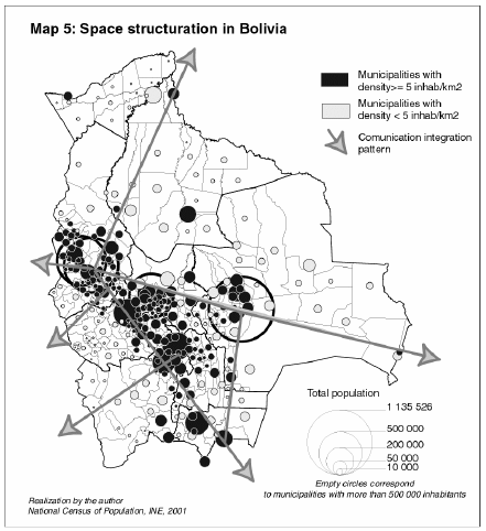
The central axis (La Paz – Santa Cruz) has a dynamic due to the presence of big cities; however the weakness of the communication system (particularly the old road Cochabamba – Santa Cruz) leaves empty locations between these cities. The real dynamic of the lowlands is in the city of Santa Cruz and not in the rest of the territory (Santa Cruz city's population represents 56% of the population of the region, or 40% of the population of the regions of Pando, Beni, Santa Cruz and Tarija).
On the contrary, the traditional axis shows a continuity of locations of territorial occupation which is reinforced by new axes of communication, La Paz – Tarija, nowadays it is almost fully asphalted.
The diagram of road integration allows us to think that this traditional axis can be reinforced by priority exchanges towards neighboring countries.
The territorial occupation has not changed significantly during the course of the last century in spite of the strong dynamic from the city of Santa Cruz and of the intermediate cities that have appeared in its periphery. The dynamic of connectivity in the Bolivian region does not leave space to think about a profound modification of this outline but instead its reinforcement, in the field of international integration. However, the demographic dynamics and the observed flows of migration let us also think that urban polarization and the settlements concentrated along these axes present a risk to the territorial equilibrium of Bolivia.
Pre-concept 3: Migration of the poor
Finally, the great idea of migration is that the population moves in order to get better work opportunities, particularly for the poor who "have nothing to lose". We have wanted to prove this hypothesis with the question: Where does the population from the poorest municipalities go to?
Map 6 gives us this information: emigration from municipalities that have more than 50% of their population in a situation of homelessness, in other words, extreme poverty.
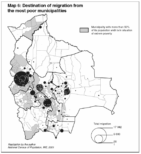
Emigration is destined to the biggest cities (mainly El Alto and Sucre) and some "opportunity" zones such as colonization zones (Yungas, Chapare and north of Santa Cruz), the border cities or mining centers. However, the amount of emigrants from the poor municipalities is minimal compared to the total emigration in Bolivia shown in diagram 1.
Emigrants from the poorest municipalities represent 12.8% of the total of emigrants at a national level. This represents 1.1% of the total population while the total of emigrants represents 8.8% with a small variation between regions.
The majority of emigrants from poor zones migrate within their region or to the surroundings of the neighboring region: the majority is in Chuquisaca and La Paz, very few in the lowland regions; only 4.9% of the emigrants who reach Santa Cruz come from poor municipalities.
Well then, it is true that the main motivation of migration is to improve living conditions and to find an activity that will let this happen; however, the image that a population have of improving their lives does not always have to do with a certain image of development linked to the means. Migration within the cultural territory has a strong feature, and added to this are the difficulties of finding the necessary resources for a long distance migration (reserved, as the CODEPO's study has shown, to people with a higher level of education).
The effects of migration
Migration does not respond to a flow model of a unique sense. The complexity of movement is the result of various factors such as geographic and cultural proximity, the presence of an attractive city, the existence of family relationships, etc., which we are still far away from knowing.
However, this differentiation of the ways of internal migration generates eye-catching demographic dynamics which are essential to study in order to understand the future of the territorial structure and to generate adequate policies.
Within these significant dynamics, we present three: the question of language distribution, the question of gender and the question of population ageing.
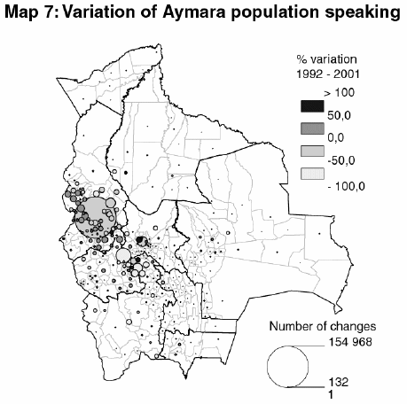
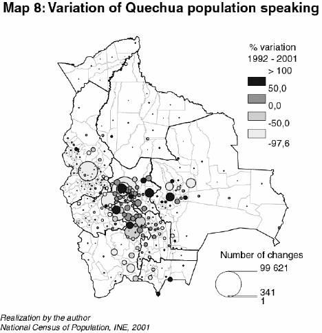
In the case of the spatial dynamic of distribution of mother tongue between 1992 and 2001 (maps 7 and 8) we can observe two different models between the population of speakers of Aymara and Quechua. On one side, stability in the zone of Aymara influence can be observed but accompanied with a process of concentration to the south of the region of La Paz and in the city of El Alto. On the other hand, the concentration of the population that speaks Quechua in urban locations is not that evident but we can observe the enlargement of the zone of Quechua influence according to the effect of migration of proximity from Cochabamba and Chuquisaca towards the region of Santa Cruz. The urban or rural character of migration is an important piece of information in order to understand cultural modifications linked to the modifications of territorial distribution: urban integration of young migrants or of second generation leads undoubtedly to a loss of language and sometimes of culture; on the contrary, migration towards rural locations allows people to keep some links of community type in which young people's participation is very important and fundamental for the maintenance of many cultural components. If the territorial and cultural nuclei remain stable in the majority of cases because the external influence (economy, culture, models of external) is of a situational type (Arreghini & Mazurek, 2004; Mazurek & Arreghini, 2006), modification of migratory behavior can become structural type transformation in the geographical distribution of cultures.
The other important effect of internal migration comes from the differentiation between female and male migration, as it is shown in map 9. The difference between the volume of male and female populations can not be generated from a difference of the ratio of genders born, it always arises from selective migration. The zones of the highlands or the zones of colonization always attract more male employment; while cities attracts more female activities. In map 9, the two lower ones (light gray) correspond to municipalities with a shortage of men, while the two upper ones (dark gray) correspond to municipalities with a surplus of men. The existence of important differences in the type of predominant activity, domestic employment or tertiary in the city for example, harvest work or colonization in the lowlands, generate an imbalance in gender distribution which can have derivative impacts. For example, migration of men from Chuquisaca leaves women and children in charge of their country house, and constitutes a factor of imbalance in the coherence of communities, and impedes social mobility of women.
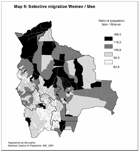
According to the studies of CODEPO (2004, p.61), the net rate of migration is not that different between men and women, hardly 1% separates the rates of immigration and emigration between both genders. It is actually the destination of migration that differentiates them.
Finally, one of the important effects is the selective migration of young people or adults in relation to older people. The distribution of emigrants in age groups is quite similar between regions: 30% are between 5 and 14 years old, 30% between 15 and 29 years old, 19.5% between 30 and 44 years old, 14% between 45 and 64 years old and 64.6% are 65 years old and above (CODEPO, 2004). This selective emigration has as a consequence the ageing of population in zones of emigration and rejuvenation in the immigration zones. This phenomenon is associated with the decrease of general fertility (in the highlands particularly) and mortality.
Map 10 presents a synthesis between migration and ageing: municipalities that attract and lose are crossed with a more or less proportion of young people or older people (rate of ageing4 lower or higher than the national average).
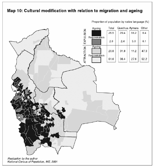
The losing population municipalities with a process of ageing are located across the whole part of the highlands, and some zones in recession like the south of the region of Cochabamba, north Potosí, the zone of Vallegrande, etc.
The evident consequence of this demographic situation is the decrease due to migration and the ageing of the labor force available in these zones. But the cultural consequence is also significant, which is shown in the associated table to the map. 56% of the Aymara speaking population is located in this zone with a strong migration and process of ageing, while Quechua and other indigenous people are located mainly in zones of attraction with a good proportion of young people in the municipalities. This situation confirms the general model of migration presented in maps 2, 3 and 7: the strong tendency of migration from the highlands towards cities, and El Alto above all, migration differentiated between Aymara and Quechua, the weak intercommunication between low and highlands at a level of mobility and migration. It is a worrying situation in relation to the future of the Aymara culture (or at least of the language) in these zones, where there is an urbanization of the Aymara.
Conclusion
The internal migration in Bolivia does not have much to do with a model of "communicating vessels" from west towards east. Many factors come into account in order to define predominant flows:
• The city of proximity is, without any doubt, the first factor of destination. The existence of jobs is a factor of priority attraction: El Alto, the mining or border cities, the services and commerce in the case of women, the job qualifications in the case of migration from city to city.
• The proximity or cultural relation constitutes a basin of privileged migration where mobility is without question more important than definitive migration. The colonization zones could be in this category in the measure that there is a significant difference between the behavior of Aymaras (of priority in the cities) and Quechuas (in rural zones).
• The existence of specific jobs which mobilizes men and women in a differentiated way; the existence of differentiated levels of education within emigrants which determines the destinations of migration.
The demographic and territorial consequences of these migrations are not insubstantial. Movements create imbalance of culture, gender or generations who influence the potential of local and national development. At an economical level, the decrease of availability of the labor force, ageing or imbalances of gender are factors that limit productive diversification, alimentary security or the profitability itself of production. At a cultural level, emigration of young people towards the city has a double effect of destructuralization of communitarian coherence and the loss of cultural foundation throughout generations. At a public management level, the demand of basic services has to be differentiated the between zones of attraction and zones of emigration, a situation frequently almost untenable without an adequate policy of territorial planning.
The territorial consequences are also worrying: a too fast growth of cities with a generation of social and spatial segregation (look for example Garfias & Mazurek, 2005 about the city of El Alto); a generation of abandoned locations, important environmental pressure in the colonization zones; conflicts between "residents and non-residents"; modification of the great national cultural equilibrium.
Internal migration needs more profound studies in order to understand these mechanisms and to generate adequate policies of human settlement. "2,505,964 people born in the country reside in a different municipality to the ones in which they were born, a magnitude that represents 31.07% of the total national population" (CODEPO, 2004). On the other hand, 732,410 people between 1996 and 2001 have made a change of residence from one municipality to another, a figure higher than that estimated for international migration (75,000 people every year according to OMS) but with territorial impacts that are much more considerable.
Bibliography
ARREGHINI, L. ; MAZUREK, H. (2004). Territoire, risque et mondialisation: quelques réflexions à partir du cas Andin. In G. David (ed.): Xème Journées de Géographie Tropicale (Orléans, 24, 25, 26 septembre 2003). Espaces Tropicaux et Risques. Du local au global. 240-260; Orléans: Presses Universitaires d'Orléans, IRD.
CODEPO (2004). Estudio de la migración interna en Bolivia. 234p., La Paz: Ministerio de Desarrollo Sostenible.
DELER, J.P. (1991). La Bolivie, enclaves sous influences. In Brunet R. (ed.): Géographie Universelle, 296-314; Paris: Belin-Reclus.
DILLEHAY, T.F. (1979). Pre-hispanic resource sharing in the Central Andes. Science, 204, 24-31.
GARFIAS, S.; MAZUREK, H. (2005) El Alto desde una perspectiva poblacional, 151 p.; La Paz: IRD, CODEPO, Alcaldía de El Alto.
HINOJOSA, A.; PÉREZ, L.; CORTEZ, G. (2000). Idas y vueltas. Campesinos tarijeños en el Norte Argentino, 106 p.; La Paz: PIEB.
HINOJOSA, A. - Comp. (2004). Migraciones transnacionales. Visiones de Norte y Sudamérica, 348 p.; La Paz: CEPLAG-UMSS, Universidad de Tolosa, PIEB, CEF, Plural Ed.
MAZUREK, H. ; ARREGHINI, L. (2006). Structuration des territoires et logiques divergentes de l'économie bolivienne. Espaces et Sociétés, 124-125: 73-91.
MAZUREK, H. (2007). Componentes de la migración, impactos territoriales y políticas: un análisis crítico. In Godard, H.; Sandoval, G.; ed.): Dinámicas de las migraciones transnacionales de los países andinos a Europa y Estados Unidos; Lima: IFEA, PIEB.
MINISTERIO DE DESARROLLO SOSTENIBLE (2001). Lineamiento de políticas de ordenamiento territorial en Bolivia, 76 p.; La Paz: MDSP, Unidad de Ordenamiento Territorial.
MURRA, J.V. (1975). Formaciones económicas y políticas del mundo andino, 339 p.; Lima: IEP.
PERRIER BRUSLÉ, L. (2005). La dernière frontière. Loin des Andes, trop près du Brésil, la frontière orientale et la construction territoriale en Bolivie. Thèse Université de Paris I, Panthéon - Sorbonne, 737 p.
SAIGNES, T. (1987). Parcours forains dans les Andes coloniales. Cahiers del Amériques Latines, Paris, 6: 33-58.
VARGAS, M. (1997). La migración temporal en la dinámica de la unidad doméstica campesina. Yachay, 26: 35-73
* This article will be published in Spanish in Revista de Humanidades y Ciencias Sociales, Vol. 14, Nº 1-2 (June – December 2008). The author holds a Doctoral Degree in Ecology by the Université Montpellier (France). He is a senior researcher both at the Institut de Recherche pour le Développement (IRD – France) and the Centro Internacional de Agricultura Tropical (CIAT – Colombia). Dr. Mazurek participates in the research project "Migration, mobility and economic development in Santa Cruz - Bolivia ", which is being executed at the Universidad Autónoma "Gabriel René Moreno" (Bolivia) under a program of scientific cooperation with the IRD (e-mail: h.mazurek@cgiar.org).
1 The news media regularly appropriates this theme insisting on an oversimplified idea of "communicative vessels" about the characteristics of people leaving or being attracted to regions and municipalities from the west towards the east. See for example La Razón on the 13 of May of 2007.
2 Estrategia Nacional de Desarrollo Agropecuario y Rural.
3 This deals with the census variable "Where have you lived during the past 5 years?" which does not signify a definite migration, but a change, definitive or not, of the place of residence. Besides, multi-residence is very frequent in Bolivia which leads us to further clarify these estimates. The figures represent the balance in 5 years and the % of migrants in relation to the population of destination in 5 years.
4 The index of ageing is calculated as a ratio between the elder population (60 years old and above) and the younger population (0 – 15 years old).


